 My GeoNetwork catalogue
yearly
Provided by
Type of resources
Available actions
Topics
Keywords
Contact for the resource
Update frequencies
Service types
-

This data set represents the yearly, accumulated results of the final (10-day) version of the fire perimeters from the "Burnt Area Daily NRT Incremental Product - Europe, Sentinel-3" dataset. The burn perimeters are spatially and temporally correlated, so that interrelated detections from consecutive observations are combined into a single feature. A perimeter is interpreted as belonging to a given event if a spatial overlap exists within a time frame of 15 days. Besides the geometry, attribute information is also combined while considering the size of the perimeter as a weighting factor. Each feature contains information about the final fire perimeter, Date/Time of the first detection, and the averaged burn severity
-
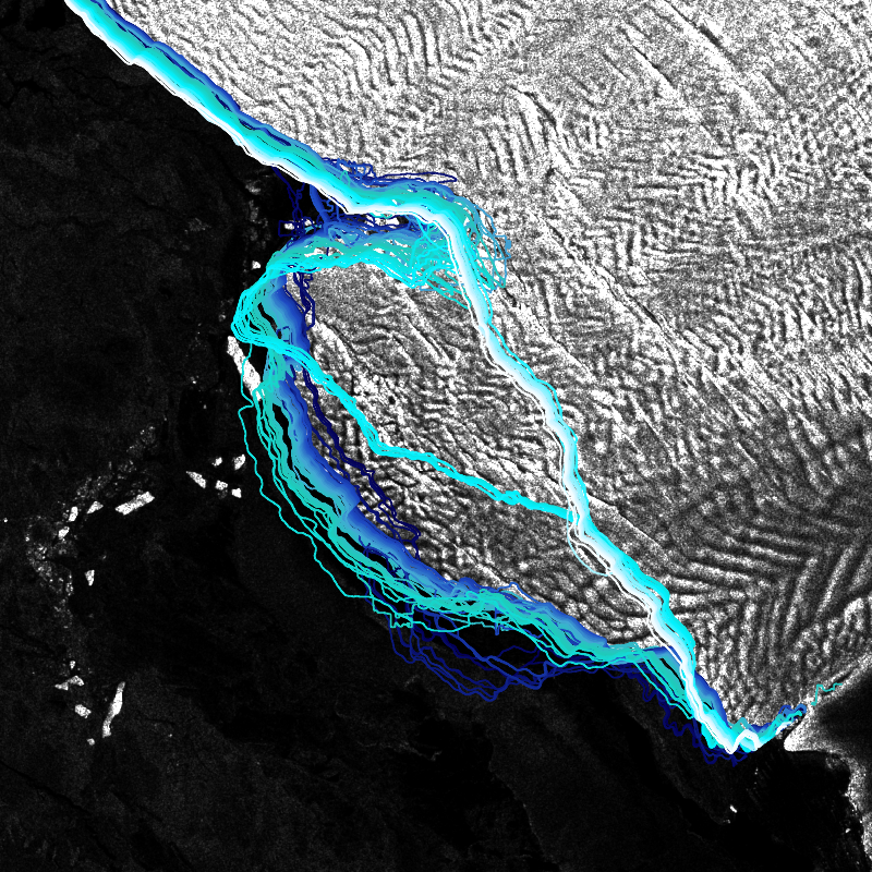
IceLines (Ice Shelf and Glacier Front Time Series) is an automated calving front monitoring service providing monthly ice shelf front time series of major Antarctic ice shelves. The provided time series allows to discover the dynamics of ice shelf front changes and calving events. The front positions are automatically derived from Sentinel-1 data based on a deep neuronal network called HED-U-Net. The time series covers the timespan 2014 to today (partly limited due to Sentinel-1 data availability). Incorrectly extracted fronts are truncated which might lead to gaps in the time series especially between December to March due to strong surface melt. Annual averages are calculated based on the extracted monthly fronts (excluding the summer months) and provide more robust results due to temporal aggregation
-

Various paramters for analysing morphodynamics in the German Bight on the basis of a 32 years time series of interpolated bathymatries (yeasr 1982 - 2012). Parameters: - "Morphological Alteration": differences in depth between two annual topographies for different periods (1, 5, 10, 30 years periods), - "Morphological Space": maximum difference in height at each model grid point (Zmax-Zmin) for different periods (1, 5, 10, 30 years), - "Morphological Drive": Difference between the maximum and the minimum annual rate of change in the period under consideration ((dz/a)max-( dz/a)min); 1, 5, 10, 30 years). With this parameter, it is possible to make a declaration as to whether a morphological alteration constantly takes place throughout the period under consideration or extreme results have occurred: - "Count Of Datasets": amount of field campaigns present in the respective period under consideration, - "Considerd Period": Time interval which is actually covered with data within the period under consideration [decimal years]. The data were generated within the framework of the German Coastal Engineering Research Council project AufMod ("Aufbau integrierter Modellsysteme zur Analyse der langfristigen Morphodynamik in der Deutschen Bucht" ["Development of integrated model systems for the analysis of long-term morphodynamics in the German Bight"], 01.11.2009-31.12.2012). For more information, please visit: https://gdi.bsh.de/en/data/Morphodynamic-Parameters-Classified-Polygons-Project-AufMod_Information_Morphodynamische_Parameter_klassifizierte_Polygone_-Projekt_AufMod-_DE.pdf
-

Various paramters for analysing morphodynamics in the German Bight on the basis of a 32 years time series aof interpolated bathymatries (yeasr 1982 - 2012). The data were generated within the framework of the German Coastal Engineering Research Council project AufMod ("Aufbau integrierter Modellsysteme zur Analyse der langfristigen Morphodynamik in der Deutschen Bucht" ["Development of integrated model systems for the analysis of long-term morphodynamics in the German Bight"], 01.11.2009-31.12.2012). - "Morphological Alteration": differences in depth between two annual topographies for different periods (1, 5, 10, 30 years periods). - "Morphological Space": maximum difference in height at each model grid point (Zmax-Zmin) for different periods (1, 5, 10, 30 years) - "Morphological Drive": Difference between the maximum and the minimum annual rate of change in the period under consideration ((dz/a)max-( dz/a)min); 1, 5, 10, 30 years). With this parameter, it is possible to make a declaration as to whether a morphological alteration constantly takes place throughout the period under consideration or extreme results have occurred - "Count Of Datasets": amount of field campaigns present in the respective period under consideration - "Considerd Period": Time interval which is actually covered with data within the period under consideration [decimal years]