 My GeoNetwork catalogue
yearly
Provided by
Type of resources
Available actions
Topics
Keywords
Contact for the resource
Update frequencies
-

This data set represents the yearly, accumulated results of the final (10-day) version of the fire perimeters from the "Burnt Area Daily NRT Incremental Product - Europe, Sentinel-3" dataset. The burn perimeters are spatially and temporally correlated, so that interrelated detections from consecutive observations are combined into a single feature. A perimeter is interpreted as belonging to a given event if a spatial overlap exists within a time frame of 15 days. Besides the geometry, attribute information is also combined while considering the size of the perimeter as a weighting factor. Each feature contains information about the final fire perimeter, Date/Time of the first detection, and the averaged burn severity
-
This product shows the mean snow cover duration (SCDmean), which is updated each year and consists of the arithmetic mean for the entire time series since the hydrological year 2001. The hydrological year begins in the meteorological autumn (October 1 of the previous year in the northern hemisphere or March 1 of the reference year in the southern hemisphere) and ends with the meteorological summer (northern hemisphere: August 31 of the reference year; southern hemisphere: February 28/29 of the following year). Analogous to the annual products for snow cover duration, the entire year as well as the early season (until mid-winter) and the late season (from mid-winter) are taken into account here. The “Global SnowPack” is derived from daily, operational MODIS snow cover product for each day since February 2000. Data gaps due to polar night and cloud cover are filled in several processing steps, which provides a unique global data set characterized by its high accuracy, spatial resolution of 500 meters and continuous future expansion. It consists of the two main elements daily snow cover extent (SCE) and seasonal snow cover duration (SCD; full and for early and late season). Both parameters have been designated by the WMO as essential climate variables, the accurate determination of which is important in order to be able to record the effects of climate change. Changes in the largest part of the cryosphere in terms of area have drastic effects on people and the environment. For more information please also refer to: Dietz, A.J., Kuenzer, C., Conrad, C., 2013. Snow-cover variability in central Asia between 2000 and 2011 derived from improved MODIS daily snow-cover products. International Journal of Remote Sensing 34, 3879–3902. https://doi.org/10.1080/01431161.2013.767480 Dietz, A.J., Kuenzer, C., Dech, S., 2015. Global SnowPack: a new set of snow cover parameters for studying status and dynamics of the planetary snow cover extent. Remote Sensing Letters 6, 844–853. https://doi.org/10.1080/2150704X.2015.1084551 Dietz, A.J., Wohner, C., Kuenzer, C., 2012. European Snow Cover Characteristics between 2000 and 2011 Derived from Improved MODIS Daily Snow Cover Products. Remote Sensing 4. https://doi.org/10.3390/rs4082432 Dietz, J.A., Conrad, C., Kuenzer, C., Gesell, G., Dech, S., 2014. Identifying Changing Snow Cover Characteristics in Central Asia between 1986 and 2014 from Remote Sensing Data. Remote Sensing 6. https://doi.org/10.3390/rs61212752 Rößler, S., Witt, M.S., Ikonen, J., Brown, I.A., Dietz, A.J., 2021. Remote Sensing of Snow Cover Variability and Its Influence on the Runoff of Sápmi’s Rivers. Geosciences 11, 130. https://doi.org/10.3390/geosciences11030130
-

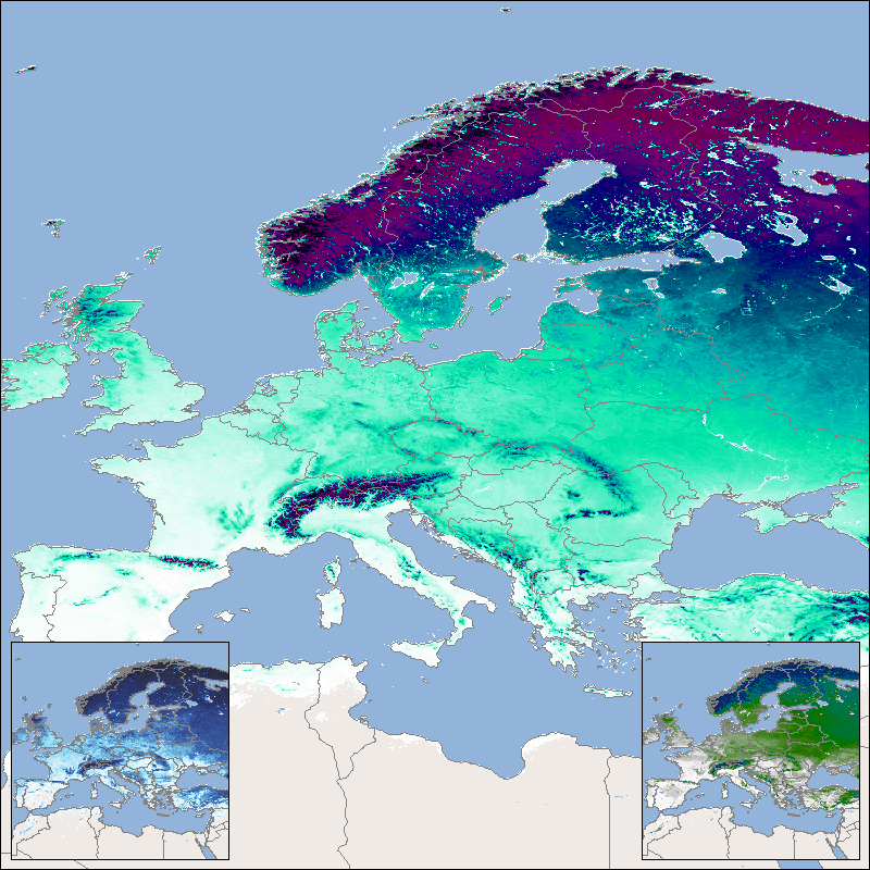
This product shows the snow cover duration for a hydrological year. Its beginning differs from the calendar year, since some of the precipitation that falls in late autumn and winter falls as snow and only drains away when the snow melts in the following spring or summer. The meteorological seasons are used for subdivision and the hydrological year begins in autumn and ends in summer. The snow cover duration is made available for three time periods: the snow cover duration for the entire hydrological year (SCD), the early snow cover duration (SCDE), which extends from autumn to midwinter (), and the late snow cover duration (SCDL), which in turn extends over the period from mid-winter to the end of summer. For the northern hemisphere SCD lasts from September 1st to August 31st, for the southern hemisphere it lasts from March 1st to February 28th/29th. The SCDE lasts from September 1st to January 14th in the northern hemisphere and from March 1st to July 14th in the southern hemisphere. The SCDL lasts from January 15th to August 31st in the northern hemisphere and from July 15th to February 28th/29th in the southern hemisphere. The “Global SnowPack” is derived from daily, operational MODIS snow cover product for each day since February 2000. Data gaps due to polar night and cloud cover are filled in several processing steps, which provides a unique global data set characterized by its high accuracy, spatial resolution of 500 meters and continuous future expansion. It consists of the two main elements daily snow cover extent (SCE) and seasonal snow cover duration (SCD; full and for early and late season). Both parameters have been designated by the WMO as essential climate variables, the accurate determination of which is important in order to be able to record the effects of climate change. Changes in the largest part of the cryosphere in terms of area have drastic effects on people and the environment. For more information please also refer to: Dietz, A.J., Kuenzer, C., Conrad, C., 2013. Snow-cover variability in central Asia between 2000 and 2011 derived from improved MODIS daily snow-cover products. International Journal of Remote Sensing 34, 3879–3902. https://doi.org/10.1080/01431161.2013.767480 Dietz, A.J., Kuenzer, C., Dech, S., 2015. Global SnowPack: a new set of snow cover parameters for studying status and dynamics of the planetary snow cover extent. Remote Sensing Letters 6, 844–853. https://doi.org/10.1080/2150704X.2015.1084551 Dietz, A.J., Wohner, C., Kuenzer, C., 2012. European Snow Cover Characteristics between 2000 and 2011 Derived from Improved MODIS Daily Snow Cover Products. Remote Sensing 4. https://doi.org/10.3390/rs4082432 Dietz, J.A., Conrad, C., Kuenzer, C., Gesell, G., Dech, S., 2014. Identifying Changing Snow Cover Characteristics in Central Asia between 1986 and 2014 from Remote Sensing Data. Remote Sensing 6. https://doi.org/10.3390/rs61212752 Rößler, S., Witt, M.S., Ikonen, J., Brown, I.A., Dietz, A.J., 2021. Remote Sensing of Snow Cover Variability and Its Influence on the Runoff of Sápmi’s Rivers. Geosciences 11, 130. https://doi.org/10.3390/geosciences11030130