 My GeoNetwork catalogue
Bodenbearbeitung
Provided by
Type of resources
Available actions
Topics
Keywords
Contact for the resource
Update frequencies
Service types
-
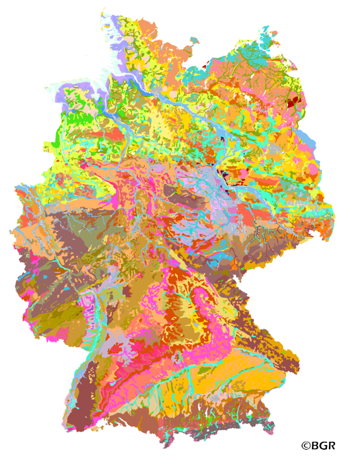
The first country wide soil map at a scale of 1:1,000,000 (BUEK1000) has been compiled on the basis of published soil maps of the former German Democratic Republic and the pre 1990 federal states of Germany. To do this, it was necessary to match the soil systems used in East and West Germany and to develop standardized descriptions of soil units. A relatively homogeneous map has resulted, which permits uniform assessment of the soils throughout Germany. The map shows 71 soil mapping units, described in the legend on the basis of the German and FAO soil systems. Each soil unit has been assigned a characteristic soil profile (Leitprofil) as an aid to map interpretation. For the first time the subdivision of the country into 12 soil regions has been represented on the map. This subdivision was coordinated with the state Geological Surveys. These soil regions will represent the highest hierarchic level of nation wide soil maps in future. The colours of soil units correspond to the standards of the 'Bodenkundliche Kartieranleitung' (KA 3; Guidelines for Soil Mapping). The various hues characterize differences in relief or soil humidity. The BUEK1000 was produced digitally. It is an important part of the spatial database integrated in the Soil Information System currently being established at the Federal Institute for Geosciences and Natural Resources (FISBo BGR). It can be used together with the characteristic soil profiles to derive thematic maps related to nation wide soil protection. The scale of the BUEK1000 makes it especially suitable for small scale evaluations at federal or EU level.
-
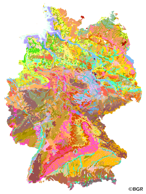
Web Map Service (WMS) of the BUEK1000. The first country wide soil map at a scale of 1:1,000,000 (BUEK1000) has been compiled on the basis of published soil maps of the former German Democratic Republic and the pre 1990 federal states of Germany. To do this, it was necessary to match the soil systems used in East and West Germany and to develop standardized descriptions of soil units. A relatively homogeneous map has resulted, which permits uniform assessment of the soils throughout Germany. The map shows 71 soil mapping units, described in the legend on the basis of the German and FAO soil systems. Each soil unit has been assigned a characteristic soil profile (Leitprofil) as an aid to map interpretation. For the first time the subdivision of the country into 12 soil regions has been represented on the map. This subdivision was coordinated with the state Geological Surveys. These soil regions will represent the highest hierarchic level of nation wide soil maps in future. The colours of soil units correspond to the standards of the 'Bodenkundliche Kartieranleitung' (KA 3; Guidelines for Soil Mapping). The various hues characterize differences in relief or soil humidity. The BUEK1000 was produced digitally. It is an important part of the spatial database integrated in the Soil Information System currently being established at the Federal Institute for Geosciences and Natural Resources (FISBo BGR). It can be used together with the characteristic soil profiles to derive thematic maps related to nation wide soil protection. The scale of the BUEK1000 makes it especially suitable for small scale evaluations at federal or EU level.
-
Geodaten der Flächen im Landkreis Nienburg/Weser, die sich im Trockenabbau befinden. Begriff Trockenabbau: Bei dieser Abbaumethode wird bei der Gewinnung der Bodenschätze kein Grundwasser freigelegt. Im Landkreis Nienburg/Weser findet Trockenabbau ausschließlich im Übertagebau statt. Untertagebau zur Gewinnung von tiefer liegenden Rohstoffen, wie z.B. Kohle oder Salz findet im Landkreis derzeit nicht statt. Im Landkreis Nienburg/Weser wird im Trockenabbauverfahren hauptsächlich Sand und Kies sowie Torf in den Hochmooren Lichtenmoor, Borsteler Moor und Siedener Moor sowie im Großen Moor bei Uchte abgebaut. Der einzige Steinbruch des Landkreises befindet sich in der Gemarkung Münchehagen.
-
Kompensationsflächen im Landkreis Hameln-Pyrmont
-
Geodaten der Flächen im Landkreis Nienburg/Weser, die sich im Nassabbau befinden. Im Landkreis Nienburg/Weser wird in einem erheblichen Umfang Sand- und Kiesabbau mit Grundwasserfreilegung betrieben bzw. geplant. Die größte Dichte an Abbaustätten besteht in folgenden Gebieten des Landkreises: - westlich der Weser südlich von Stolzenau in der Gemarkung Raddestorf an der B 215, Samtgemeinde Uchte, bis Diethe-Langern, Gemeinde Stolzenau, - nördlich von Stolzenau westlich der Weser zwischen Stolzenau „Große Brinkstraße" und der Gemeindeverbindungsstraße Landesbergen-Anemolter, - östlich der Weser zwischen der Landesgrenze zu Nordrhein-Westfalen im Süden und dem „Kleinen Maschsee", Gemarkung Landesbergen, im Norden, - Weiter nördlich wurde ein Bodenabbau in der Gemarkung Estorf begonnen. Außerdem baut eine Firma in der Gemarkung Schweringen östlich der Weser großflächig Sand und Kies ab.
-

Das Informationssystem ISIP bündelt vorhandene Informationen und aktuelle Situationen im Pflanzenbau entsprechend der Kulturart und der Region. Vielfältige Dienste können darüber hinaus - zugeschnitten auf die Bedürfnisse der Berater und Praktiker - abonniert werden. Neben der Region Niedersachsen, können die Regionen Brandenburg, Baden-Württemberg, Bayern, Mecklenburg-Vorpommern, Nordrhein-Westfalen, Rheinland-Pfalz, Saarland, Sachsen, Sachsen-Anhalt, Schleswig-Holstein und Thüringen ausgewählt werden, um Informationen zu erhalten.
-
The Land use-stratified soil map of Germany at scale 1:1,000,000 (BUEK1000N), version 2.32, presents the distribution of soils and their associations nationwide in a uniform form at the aggregation level of the lead soil associations, which were intersected with 14 generalized and adjusted land use classes from CORINE Land Cover 1990. It did not appear as an analog map like the three subextracts of cropland, grassland, and forest. The digital map graphic is supplemented by climate regions, soil regions, and soil landscapes. The legend comprises 69 soil legend units with leading and accompanying soils (and information on the soil depth, the soil types, water conditions and the parent material), arranged according to soil distribution areas, partial legends arable land, grassland and forest, each subdivided according to climatic regions. The area-related content data are composed of 76 forest reference profiles, 78 cropland reference profiles, and 56 grassland reference profiles and are stored in a relational database. An additional 54-page booklet with explanations of the BUEK1000N can be purchased at GeoCenter Touristik Medienservice GmbH in 70565 Stuttgart, Germany, if required. The digital map graphics of version 2.32 are based on the topographic map of the Digital Landscape Model 1:1,000,000 (DLM1000) of the Federal Agency for Cartography and Geodesy from 2019.
-
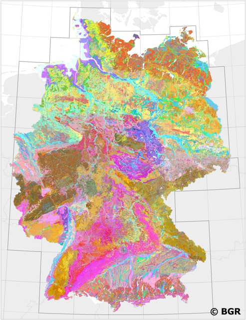
Web Map Service (WMS) of BUEK200 series. The soil map 1:200,000 (BUEK200) is prepared by the Federal Institute for Geosciences and Natural Resources (BGR) in cooperation with the National Geological Surveys (SGD) of the federal states in the sheet line system of the Topographic Map 1:200,000 (TUEK200) and is published in 55 individual map sheets. The digital data management provides a detailed, nationwide uniform and comprehensive information base for statements on land use and soil protection across the states. The soil inventories and their spatial distribution on the territory of each map sheet is currently described in terms of legend units structured by soil regions and landscapes. Each legend unit contains soil systematic information as well as information about the soil parent material of each dominant and associated soil.
-
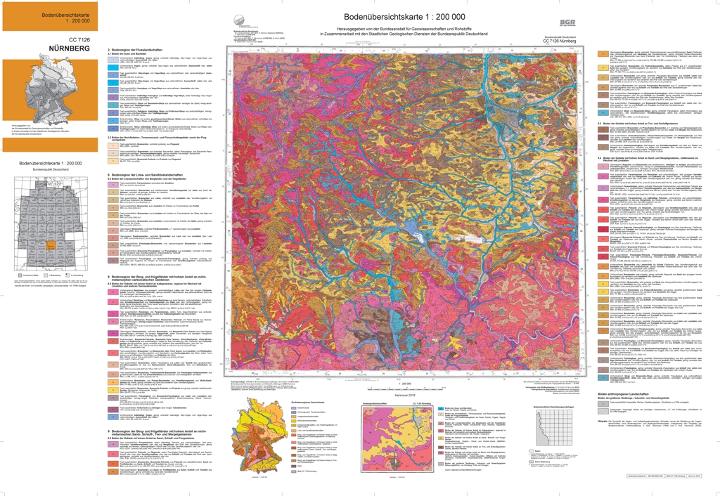
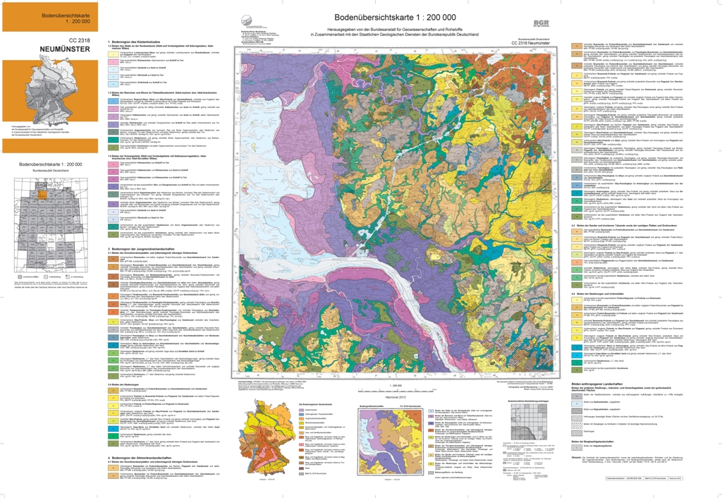
The soil map 1:200,000 (BUEK200) is prepared by the Federal Institute for Geosciences and Natural Resources (BGR) in cooperation with the National Geological Surveys (SGD) of the federal states in the sheet line system of the Topographic Map 1:200,000 (TUEK200) and is published in 55 individual map sheets. The digital data management provides a detailed, nationwide uniform and comprehensive information base for statements on land use and soil protection across the states. Information about the current state of processing can be found on the BGR website about soil. The soil inventories and their spatial distribution on the territory of this map sheet is described in terms of 77 legend units structured by soil regions and landscapes. Each legend unit contains soil systematic information as well as information about the soil parent material of each dominant and associated soil.
-
The soil map 1:200,000 (BUEK200) is prepared by the Federal Institute for Geosciences and Natural Resources (BGR) in cooperation with the National Geological Surveys (SGD) of the federal states in the sheet line system of the Topographic Map 1:200,000 (TUEK200) and is published in 55 individual map sheets. The digital data management provides a detailed, nationwide uniform and comprehensive information base for statements on land use and soil protection across the states. Information about the current state of processing can be found on the BGR website about soil. The soil inventories and their spatial distribution on the territory of this map sheet is described in terms of 90 legend units structured by soil regions and landscapes. Each legend unit contains soil systematic information as well as information about the soil parent material of each dominant and associated soil.Last dataset update on November 11, 2009.