 www.geodatenkatalog.de (S1L)
Keyword
Oberflächengeologie
29 record(s)
Provided by
Type of resources
Available actions
Topics
Keywords
Contact for the resource
Update frequencies
Service types
-
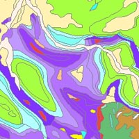
The “Geological Map of Germany 1:1,000,000 OneGeology-Europe (GK1000-1GE)” shows Germany’s surface geology: All geological units are described by their age (stratigraphy) and composition (lithology). The geological units and terms used in this map were semantically harmonized within the OneGeology-Europe project and have been - in a number of regions - geometrically and semantically made consistent with the neighbouring OneGeology-Europe participants.
-
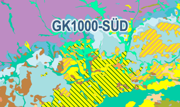
The Geological Map of Southern Germany 1:1,000,000 (GK1000-SÜD) was compiled as part of the BGR project ‘AGNES’ (Automated generalisation / Derivation of geological spatial data). With the help of the modified FME-based AutoGen workflow - developed at the State Office for Geology, Raw Materials and Mining in Baden-Württemberg (LGRB) - the GK1000-SÜD was derived on the basis of current areal data at a detail scale of 1:25,000 / 1:50,000 from the SGD of Bavaria and Baden-Württemberg, which were made available to the BGR as part of the ‘ConSent’ project. The GK1000-SÜD contains a lithostratigraphy layer with the corresponding legend. The legend is mainly based on the Superordinate General Legend (SGL) developed in the ‘ConSent‘ project with individual additions and changes according to the lists of terms in the ‘Guidelines for the Compilation of Geological Maps‘. The GK1000-SÜD does not currently contain any tectonic line elements or ice margins. The integration of the current tectonic line elements and the current ice margins from the SGD is to be carried out as part of a further project.
-
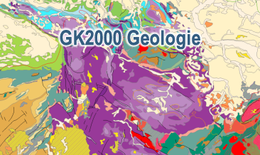
The digital GK2000 Geology represents the surface geology of Germany and adjacent regions at a scale of 1:2,000,000. The map includes 30 units differentiated according to their age of formation. It also contains information on the distribution of volcanic, plutonic and metamorphic rocks. Furthermore, the map shows tectonic line elements, marginal positions of the ice shield of the last glacial periods as well as the impact craters Nördlinger Ries and Steinheimer Becken.
-
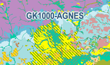
This new version of the Geological Map of the Federal Republic of Germany 1:1,000,000 (GK1000-AGNES) was compiled as part of the BGR project ‘AGNES’ (Automated generalisation / Derivation of geological spatial data). With the help of the modified FME-based AutoGen workflow - developed at the State Office for Geology, Raw Materials and Mining in Baden-Württemberg (LGRB) - new GK1000 surface data were derived semi-automatically from the current GÜK250 areal data. The GK1000-AGNES comprises the three layers lithostratigraphy, petrography and geogenesis including the respective legend. It should be noted that the current GÜK250 does not primarily consist of the latest information or areal spatial data from the State Geological Surveys (SGD). In addition, the tectonic line elements of the current GÜK250 do not have sufficient attribution for semi-automatic generalisation. In other words, there is no differentiation between main fault and secondary fault. Accordingly, a generalisation / derivation of the tectonic line elements was not performed. For the sake of completeness, the tectonic line elements and also the ice margins of the previous GK1000 were therefore integrated into the GK1000-AGNES. The inclusion of the current tectonic line elements, the current surface data and the current ice margins from the SGD is to be carried out as part of a further project.
-

The digital GK2750 Geology represents the surface geology of Germany at a scale of 1:2,750,000. The map comprises 28 units differentiated according to their age of formation. It also contains information on the distribution of volcanic and plutonic rocks. Furthermore, the map shows tectonic line elements, marginal positions of the ice shield of the last glacial periods and the impact formation Nördlinger Ries.
-
The Geological Map of Southern Germany 1:1,000,000 (GK1000-SÜD) was compiled as part of the BGR project ‘AGNES’ (Automated generalisation / Derivation of geological spatial data). With the help of the modified FME-based AutoGen workflow - developed at the State Office for Geology, Raw Materials and Mining in Baden-Württemberg (LGRB) - the GK1000-SÜD was derived on the basis of current areal data at a detail scale of 1:25,000 / 1:50,000 from the SGD of Bavaria and Baden-Württemberg, which were made available to the BGR as part of the ‘ConSent’ project. The GK1000-SÜD contains a lithostratigraphy layer with the corresponding legend. The legend is mainly based on the Superordinate General Legend (SGL) developed in the ‘ConSent‘ project with individual additions and changes according to the lists of terms in the ‘Guidelines for the Compilation of Geological Maps‘. The GK1000-SÜD does not currently contain any tectonic line elements or ice margins. The integration of the current tectonic line elements and the current ice margins from the SGD is to be carried out as part of a further project.
-
This new version of the Geological Map of the Federal Republic of Germany 1:1,000,000 (GK1000-AGNES) was compiled as part of the BGR project ‘AGNES’ (Automated generalisation / Derivation of geological spatial data). With the help of the modified FME-based AutoGen workflow - developed at the State Office for Geology, Raw Materials and Mining in Baden-Württemberg (LGRB) - new GK1000 surface data were derived semi-automatically from the current GÜK250 areal data. The GK1000-AGNES comprises the three layers lithostratigraphy, petrography and geogenesis including the respective legend. It should be noted that the current GÜK250 does not primarily consist of the latest information or areal spatial data from the State Geological Surveys (SGD). In addition, the tectonic line elements of the current GÜK250 do not have sufficient attribution for semi-automatic generalisation. In other words, there is no differentiation between main fault and secondary fault. Accordingly, a generalisation / derivation of the tectonic line elements was not performed. For the sake of completeness, the tectonic line elements and also the ice margins of the previous GK1000 were therefore integrated into the GK1000-AGNES. The inclusion of the current tectonic line elements, the current surface data and the current ice margins from the SGD is to be carried out as part of a further project.
-
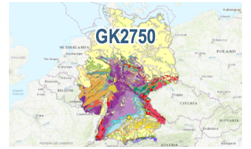
The digital GK2750 Geology represents the surface geology of Germany at a scale of 1:2,750,000. The map comprises 28 units differentiated according to their age of formation. It also contains information on the distribution of volcanic and plutonic rocks. Furthermore, the map shows tectonic line elements, marginal positions of the ice shield of the last glacial periods and the impact formation Nördlinger Ries.
-

The digital GK2000 Geology represents the surface geology of Germany and adjacent regions at a scale of 1:2,000,000. The map includes 30 units differentiated according to their age of formation. It also contains information on the distribution of volcanic, plutonic and metamorphic rocks. Furthermore, the map shows tectonic line elements, marginal positions of the ice shield of the last glacial periods as well as the impact craters Nördlinger Ries and Steinheimer Becken.