 My GeoNetwork catalogue
PlanetScope
Provided by
Type of resources
Topics
Keywords
Contact for the resource
Update frequencies
-
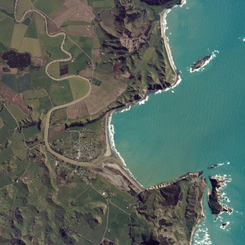
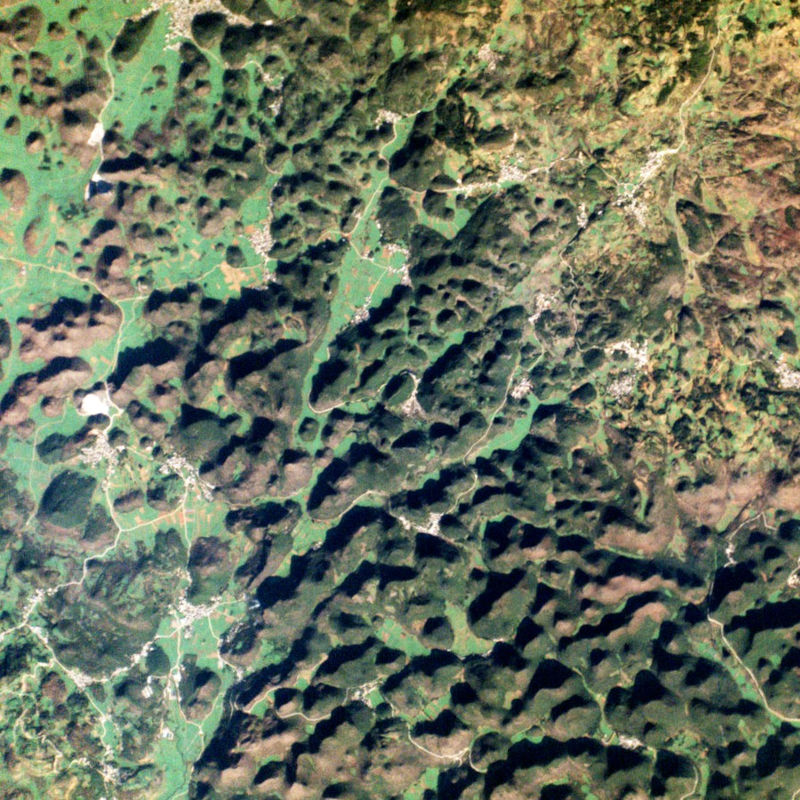
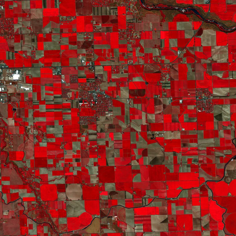
The PlanetScope satellite constellation, called ‘Flock’, consists of multiple launches of groups of individual Dove satellites into a 400 km orbit. Some of them were launched from the ISS. Therefore, on-orbit capacity is constantly improving in capability or quantity. Each Dove satellite is a CubeSat with a size of 10 x 10 x 34 cm. The complete PlanetScope constellation of approximately 130 satellites is able to image the entire land surface of the Earth every day, equating to a daily collection capacity of 200 million km². In 2014 the first Dove satellites started operationally acquiring images from the earth’s surface. The optical sensors mounted on the individual Dove satellites operate in the visual and near-infrared parts of the electromagnetic spectrum with a spatial resolution between 3 and 5 meters. A third generation of PlanetScope sensors (known as SuperDove or PSB.SD) is currently in orbit and is producing limited quantities of imagery with 5 spectral bands (BGRNIR + Red Edge). These satellites have the potential to produce imagery with 8 separate spectral bands. The PlanetScope data of this collection has been purchased by the German Space Agency with funds from the Ministry of Economy and is available for Germany-based researchers for scientific use. The data collection is maintained by the German Satellite Data Archive (D-SDA) of DLR’s Earth Observation Center and can be accessed via the EOWEB Geoportal. This collection comprises PlanetScope L1B Basic Scene 3-band natural color RGB products. The PlanetScope Basic Scene product is a Scaled Top of Atmosphere Radiance (at sensor) and sensor corrected product, providing imagery as seen from the spacecraft without correction for any geometric distortions inherent in the imaging process. It has a scene-based framing, and is not mapped to a cartographic projection.
-
The PlanetScope satellite constellation, called ‘Flock’, consists of multiple launches of groups of individual Dove satellites into a 400 km orbit. Some of them were launched from the ISS. Therefore, on-orbit capacity is constantly improving in capability or quantity. Each Dove satellite is a CubeSat with a size of 10 x 10 x 34 cm. The complete PlanetScope constellation of approximately 130 satellites is able to image the entire land surface of the Earth every day, equating to a daily collection capacity of 200 million km². In 2014 the first Dove satellites started operationally acquiring images from the earth’s surface. The optical sensors mounted on the individual Dove satellites operate in the visual and near-infrared parts of the electromagnetic spectrum with a spatial resolution between 3 and 5 meters. A third generation of PlanetScope sensors (known as SuperDove or PSB.SD) is currently in orbit and is producing limited quantities of imagery with 5 spectral bands (BGRNIR + Red Edge). These satellites have the potential to produce imagery with 8 separate spectral bands. The RapidEye Science Archive (RESA), which allows Germany-based researchers to apply for free PlanetScope imagery, is operated by the German Satellite Data Archive (D-SDA) of DLR’s Earth Observation Center and can be accessed via the EOWEB Geoportal. New PlanetScope data as well as archive data which is not yet part of the RESA collections can be applied for at Planet Labs Germany GmbH under the RESA contract. For more information see: https://www.planet.com/resa/ This collection comprises the PlanetScope L3A OrthoTile products which are orthorectified as individual 25 km by 25 km tiles referenced to a fixed, standard image tile grid system. The OrthoTile products are radiometrically-, sensor-, and geometrically-corrected and aligned to a cartographic map projection. The Surface Reflectance layer which corrects for the effects of the Earth's atmosphere is included in the product.
-
The PlanetScope satellite constellation, called ‘Flock’, consists of multiple launches of groups of individual Dove satellites into a 400 km orbit. Some of them were launched from the ISS. Therefore, on-orbit capacity is constantly improving in capability or quantity. Each Dove satellite is a CubeSat with a size of 10 x 10 x 34 cm. The complete PlanetScope constellation of approximately 130 satellites is able to image the entire land surface of the Earth every day, equating to a daily collection capacity of 200 million km². In 2014 the first Dove satellites started operationally acquiring images from the earth’s surface. The optical sensors mounted on the individual Dove satellites operate in the visual and near-infrared parts of the electromagnetic spectrum with a spatial resolution between 3 and 5 meters. A third generation of PlanetScope sensors (known as SuperDove or PSB.SD) is currently in orbit and is producing limited quantities of imagery with 5 spectral bands (BGRNIR + Red Edge). These satellites have the potential to produce imagery with 8 separate spectral bands. The PlanetScope data of this collection has been purchased by the German Space Agency with funds from the Ministry of Economy and is available for Germany-based researchers for scientific use. The data collection is maintained by the German Satellite Data Archive (D-SDA) of DLR’s Earth Observation Center and can be accessed via the EOWEB Geoportal. This collection comprises the PlanetScope L1B Basic Scene 4-band multispectral image products with three visual RGB and one near-infrared band. The Basic Scene product is a scaled Top of Atmosphere Radiance (at sensor) and sensor corrected product, providing imagery as seen from the spacecraft without correction for any geometric distortions. It has a scene-based framing, and is not mapped to a cartographic projection. If available, the Surface Reflectance layer which corrects for the effects of the Earth's atmosphere is added to the product.
-

Der rasche Ausbau der erneuerbaren Energiequellen stellt eine große Herausforderung dar, wenn es darum geht, die Energieentwicklung mit konkurrierenden Interessen in Einklang zu bringen. Dies unterstreicht die Notwendigkeit präziser raumbezogener Daten, um eine effektive Bilanzierung, Steuerung oder Bewertung der Einhaltung gesetzlicher Vorgaben zu ermöglichen. In Deutschland stellt das vom Bundesnetzagentur betriebene Marktstammdatenregister (MaStR) eine weit verbreitete Datenquelle für standort- und anlagenspezifische Informationen dar. Der vorliegende Datensatz baut auf dem Marktstammdatenregister auf und verbessert dessen räumliche Genauigkeit für Onshore-Windkraftanlagen durch die Nutzung hochauflösender Fernerkundungsdaten und Deep Learning gestützter Objekterkennung. Der Datensatz besteht aus Punktgeometrien von Windenergieanlagen an Land in Deutschland. Die Windkraftanlagen wurden mithilfe des Objekterkennungsalgorithmus YOLO auf hochauflösenden Satellitenbild-Zeitreihen von PlanetScope detektiert. Die Inferenz erfolgte auf monatlichen PlanetScope-Basiskarten (Global Monthly Basemaps) für die Monate April bis Oktober der Jahre 2018 bis 2024, mit insgesamt 45 deutschlandweiten Inferenzdurchläufen. Das Trainingsdatenset basiert auf den von Manske & Schmiedt (2023) am UFZ semi-manuell korrigierten Standortdaten des Marktstammdatenregisters für die Jahre 2021, 2022 und 2023. Dabei wurden Windkraftanlagen standortgleichmäßig ausgewählt, um eine geografisch ausgewogene Trainingsstichprobe zu gewährleisten. Zusätzlich wurden Negativbeispiele in das Trainingsset aufgenommen. Diese wurden sowohl zufällig aus ganz Deutschland ausgewählt (mit Ausschlusszonen um Windkraftstandorte) als auch gezielt aus Objektklassen, die häufig zu Fehlklassifizierungen führen (z. B. Strommasten, Mobilfunktürme), basierend auf Daten aus OpenStreetMap. Der Datensatz wurde in mehreren Iterationen verfeinert: Schlechte anfängliche Labels, die nicht zuverlässig über mehrere Zeitpunkte hinweg vom trainierten Modell erneut erkannt wurden, wurden gefiltert. Zusätzlich wurden Szenen ergänzt, bei denen das Modell Schwierigkeiten hatte. Die monatlichen Detektionen von Windkraftanlagen über Deutschland hinweg wurden zeitlich aggregiert. Hierzu wurden alle Detektionen zusammengeführt, die innerhalb eines bestimmten Puffers über die Zeit hinweg wiederholt erkannt wurden. Die Zeitreihe der Erkennungszeitpunkte wurde als Attribut an die aggregierten Punkte angefügt. Um Detektionsrauschen zu filtern, kann der Datensatz nach einer Mindestanzahl von Erkennungen pro Punkt gefiltert werden. In zukünftigen Arbeiten planen wir, den Datensatz um aktuelle Monate zu erweitern, die Nachbearbeitung zur Eliminierung von Fehlklassifikationen zu verbessern sowie für jede Erkennung eine Verlinkung zur jeweiligen ID im Marktstammdatenregister bereitzustellen.
-
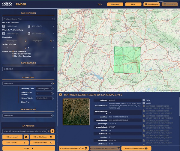
Nicht nur die CODE-DE Archive können von registrierten CODE-DE Nutzern mit einer Reihe von Funktionen abgefragt werden, sondern auch die CREODIAS und Copernicus Contributing Missions Datenkataloge sind zugänglich. Der geographische Bereich einer Abfrage kann auf der Karte durch Polygone oder Punktkoordinaten definiert werden. Eine API-Abfrage wird zur späteren Verwendung in der eigenen Anwendung zur Verfügung gestellt. Darüber hinaus können registrierte Nutzer Verarbeitungsanfragen mit Hilfe vordefinierter Prozessoren für Sentinel-1- und Sentinel-2-Daten stellen. Der EO Finder dient als einer der Zugangspunkte zu einer einsatzbereiten Prozessierungskette für Erdbeobachtungsdaten, auf die jeder registrierte Nutzer von CODE-DE Zugang hat. Die Funktionalitäten reichen dabei von einfacher Vorverarbeitung bis hin zu fortgeschritteneren Algorithmen zur Atmosphärenkorrektur. - Verfügbare Daten im CODE-DE-Katalog: Sentinel-1, Sentinel-2, Sentinel-3, Sentinel-5P, Sentinel-6, Copernicus DEM (COP-DEM), MODIS / TerraAqua - Verfügbare Daten im CREODIAS-Katalog: Sentinel-1, Sentinel-2, Sentinel-3, Sentinel-5P, Landsat-5 ESA Archive, Landsat-7 ESA Archive, Landsat-8 ESA Archive - Verfügbare Daten im Copernicus Contributing Missions-Katalog: IRS-P5 CartoSat-1, Deimos-2, GeoEye-1, Ikonos-2, KOMPSAT-2, KOMPSAT-3, PlanetScope, Pleiades-1, QuickBird-2, RapidEye, IRS-P6 Resourcesat-1, IRS-P2 Resourcesat-2, SPOT-5, SPOT-6, SPOT-7, SkySat, SuperView-1, WorldView-1, WorldView-2, WorldView-3 - Verfügbare Prozessoren für Sentinel-1: SLC Interferometry (12 days), SLC Interferometry (6 days), Terrain-corrected backscatter - Verfügbare Prozessoren für Sentinel-2: FORCE Atmospheric Correction / Cloud Mask generation, SNAP-Biophysical, SNAP-C2RCC