 My GeoNetwork catalogue
age
Provided by
Type of resources
Available actions
Service types
-
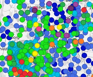
The German Borehole Locations (GBL) contains all disposable borehole data in the Federal Republic of Germany provided by the German Survey Organizations (GSO). The 16 GSO are responsible for data storage, processing and transmission of all borehole related data. In the context of a nationwide cooperation project the header information of borehole data is collected by the BGR via the exchange format BoreholeML to establish a centralized access point. This service permits an easy access to the accumulated borehole data from the participating federal states. The first two aggregated layer show the drilling density distribution in a defined raster, while the single locations only appear in greater scales. The header data is queriable from each location. The web application Borehole Map Germany makes use of this service as one major source https://boreholemap.bgr.de/
-
The "Borehole Map Germany" provides information on the geology of the subsurface in the Federal Republic of Germany and contains approx. 2 million boreholes (total length approx. 80,000 km). The application resulted from a cooperation between the BGR and the Geological Survey Organisations of Germany (SGD), which are responsible for the management and long-term storage of the borehole information shown. The BoreholeML format, which is the common denominator of all drilling data in Germany to ensure interoperability, was developed as the basis for cross-national data exchange. The application displays metadata of boreholes, strata data, groundwater measurements, evidence of loggings and samplings, casing and technical drilling data. This makes the data suitable for subsoil investigations, well construction or pipeline construction. A search and an export function work on borehole metadata level. The application starts with a tiled view of the borehole density distribution in Germany, which changes to an view of all single boreholes from a scale 1:80,000. The data is updated irregularly. Unfortunately, not all SGD distribute their data to the application yet.
-
The German Borehole Locations (GBL) provides access to borehole data in the Federal Republic of Germany provided by the Geological State Organisations (GSO). In Germany, the GSO are responsible for the storage, processing and release of information on boreholes. Within the framework of a joint project, the drilling data are compiled centrally at BGR in a generalized form using the BoreholeML exchange format. The spatial data set contains the transmitted header information of the boreholes from the participating federal states in BoreholeML coding. This coding can be resolved into plain text via the supplied Data Specification -codeLists-. The same information is also available in the Borehole Map Germany https://boreholemap.bgr.de/ on the tab “Header Information” for each drilling.