 My GeoNetwork catalogue
SRTM
Provided by
Type of resources
Available actions
Keywords
Contact for the resource
Update frequencies
Service types
-
This WMS provides access to different elevation products provided by the Earth Observation Center (EOC) of the DLR.
-
The SRTM X-SAR Elevation Mosaic is an aggregation of DLR's SRTM X-SAR DTED files. The DTED Level-2 files have been generated from Synthetic Aperture Radar (SAR) data acquired by the German-Italian X-band interferometric SAR system during the Shuttle Radar Topography Mission (SRTM) between February 11 and 22, 2000. The X-band system was flown and operated onboard the Space Shuttle Endeavor, along with a NASA C-Band SAR system. The SRTM project page at DLR provides additional information on the SRTM X-band mission ( http://www.dlr.de/eoc/en/desktopdefault.aspx/tabid-5515/9214_read-17716/ ). Further details on the mission in general, the technology, accuracies, and applications are available in http://www2.jpl.nasa.gov/srtm/SRTM_paper.pdf . The original DTED files have been grouped and mosaicked into 30 x 30 degree tiles. Six out of the total of 48 tiles were empty since they do not contain any DTED files. The resulting 42 tiles are stored as uncompressed GeoTIFF files. The files have been supplemented with nine cubic convolution resampled overviews for fast web delivery.
-

The SRTM X-SAR Hillshade Mosaic is a greyscale shaded relief based on the SRTM X-SAR Elevation Mosaic. Combined with the latter, it can be used to add a 3d effect and enhance the visual resolution by pronouncing peaks and valleys.
-

The SRTM X-SAR Error Mosaic is based on the height error map (HEM, see SRTM PDF http://www.dlr.de/eoc/Portaldata/60/Resources/dokumente/7_sat_miss/SRTM-XSAR-DEM-DTED-1.1.pdf) and provides a local measure of the achieved accuracy. It is statistically determined from a neighborhood of image cells mainly considering the phase and baseline stability. Thus it describes the precision relative to the surrounding. The determination of the absolute accuracy requires the consideration of reference measures.
-
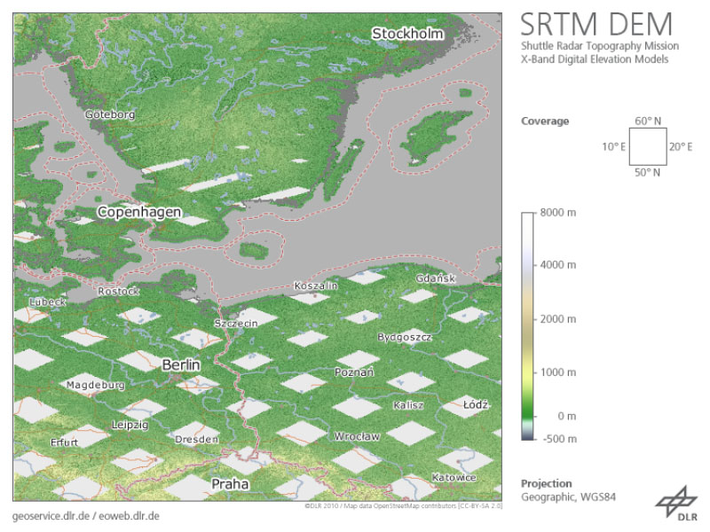
The Shuttle Radar Topography Mission (SRTM, DTS-99) from February 11 to 22, 2000 was an US-German-Italian effort to produce a first global digital elevation model (DEM). The German Aerospace Center (DLR) and the Italian Space Agency (ASI) complemented the US C-band Synthetic Aperture Radar (SAR) payload of NASA/JPL with an additional X-SAR instrument. The SRTM X-SAR DEM was generated at DLR from this instrument’s data using radar interferometry technique. The data was acquired simultaneously from aboard the Space Shuttle Endeavor employing two SAR antennas, one inside the Space Shuttle’s cargo bay, the other at the end of a 60 m extension pole. A substantial portion of the global land surface between 60° northern and 58° southern latitude was covered. As the orbit flown and imaging period of the SRTM mission had been optimized for the US C-band system, the German-Italian X-SAR with narrower aperture angle imaged data only along roughly 50 km wide orbital ground traces. Therefore, the dataset available shows a grid-like coverage. The original SRTM X-SAR DTED DEMs have been merged to 10° by 10° tiles, converted to GeoTIFF format and packaged into zip-archives. Each zip-file contains the DEM dataset, the corresponding height error map (HEM), a quicklook png-image, a kml-overlay and a readme document. The filename of the zip-archive specifies the bottom left coordinate of each tile. The zip-archives can be downloaded via the EOC Download Service. For more information see: https://geoservice.dlr.de/resources/licenses/srtm_xsar/DLR_SRTM_XSAR_ReadMe.pdf
-

The SRTM X-SAR Elevation Mosaic is an aggregation of DLR's SRTM X-SAR DTED tiles. The SRTM X-SAR Color-Coded Elevation Mosaic combines the SRTM X-SAR Elevation and Hillshade Mosaic Datasets to produce a hypsometric colored and shaded relief of the SRTM X-SAR DTED tiles.