 My GeoNetwork catalogue
atlas
Provided by
Type of resources
Available actions
Keywords
Update frequencies
Service types
-
-

-

-

-
-
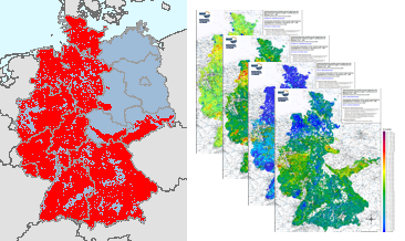
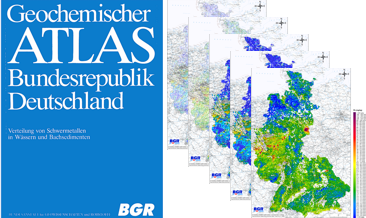
Between 1975 and 1986, geochemical investigations were carried out by the Federal Institute for Geosciences and Natural Resources (BGR) on the territory of the then Federal Republic of Germany and by the Central Geological Institute (ZGI) of the former GDR in the area of the pre-Upper Permian bedrock units in the southern part of the former GDR, which lie on the earth's surface or are slightly covered by the Cenozoic. Approximately 98,000 water and 87,500 stream sediment samples were taken and geochemically analysed. The results of these investigations were published in the "Geochemical Atlas of the Federal Republic of Germany" (Fauth et al., 1985) and in the "Final Report on the Comparative Evaluation of the Raw Material Potential in the Bedrock Units of the GDR" (Röllig et al., 1990; in German). The geochemical data collected as part of these investigations, which cover a large part of the area of today's Federal Republic of Germany, are unique in their high sampling density. All subsequent geochemical investigations were carried out with a much lower sample density. These valuable and irretrievable data have been generally accessible via the BGR geoportal since their digital processing and provision in 2022 (Geochemical Atlas of the Federal Republic of Germany) and 2023 (Geochemical Prospection in the bedrock units in the southern part of the former GDR). However, a direct comparison of the maps produced for the two sub-areas is not possible due to the differences in the analytical methods used in the investigations (investigated element spectrum, analytical quality, determination limits, ...). Nevertheless, for some of the investigated elements and parameters it is possible to summarise the results of these geochemical investigations, which are unique in their high occupancy density, with appropriate adjustments (determination limits, representable content ranges, classification of the map legends, ...). Such summarised representations are now being made available for the first time via the BGR geoportal. The downloads show the distribution of Vanadium contents in stream sediments in four different coloured point and colour shaded contour maps.
-
In the former GDR, investigations were carried out between 1980 and 1990 to estimate the raw material potential in the pre-Upper Permian bedrock units (Flechtingen-Rosslau Hills, Harz Mountains, Saxon Granulite Mountains, Thuringian Forest, Thuringian-Vogtlandian Slate Mountains, Ore Mountains, Elbe Valley Region/Lusatia), which lie at the earth's surface or are slightly covered by the Cenozoic. Part of these investigations was a geochemical prospection in the area of the above mentioned bedrock units. Approximately 18,000 water and 17,500 stream sediment samples were taken and geochemically analysed over an area of almost 15,000 km². The results of these investigations were documented in sub-reports on the individual bedrock units as well as in the "Final Report on the Comparative Evaluation of the Raw Material Potential in the Bedrock Units of the GDR" (Röllig et al., 1990; in German). These data from the bedrock units in the southern part of the former GDR are unique in their high sampling density (> 1 sample/km²) and provide a comprehensive geochemical survey of these areas. All later geochemical investigations (Geochemical Atlas 2000 as well as within the framework of GEMAS and FOREGS) were carried out with a much lower sampling density. These valuable and irretrievable data are now made generally available via the BGR geoportal. In addition to the digital provision of the original data material, area-wide distribution maps are made available for the first time, which were generated using modern computer-assisted methods. The downloads show the distribution of Yttrium contents in stream sediments in four different coloured point and colour shaded contour maps.
-
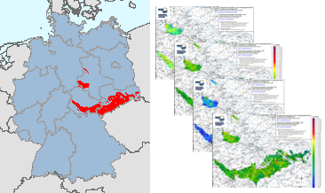
In the former GDR, investigations were carried out between 1980 and 1990 to estimate the raw material potential in the pre-Upper Permian bedrock units (Flechtingen-Rosslau Hills, Harz Mountains, Saxon Granulite Mountains, Thuringian Forest, Thuringian-Vogtlandian Slate Mountains, Ore Mountains, Elbe Valley Region/Lusatia), which lie at the earth's surface or are slightly covered by the Cenozoic. Part of these investigations was a geochemical prospection in the area of the above mentioned bedrock units. Approximately 18,000 water and 17,500 stream sediment samples were taken and geochemically analysed over an area of almost 15,000 km². The results of these investigations were documented in sub-reports on the individual bedrock units as well as in the "Final Report on the Comparative Evaluation of the Raw Material Potential in the Bedrock Units of the GDR" (Röllig et al., 1990; in German). These data from the bedrock units in the southern part of the former GDR are unique in their high sampling density (> 1 sample/km²) and provide a comprehensive geochemical survey of these areas. All later geochemical investigations (Geochemical Atlas 2000 as well as within the framework of GEMAS and FOREGS) were carried out with a much lower sampling density. These valuable and irretrievable data are now made generally available via the BGR geoportal. In addition to the digital provision of the original data material, area-wide distribution maps are made available for the first time, which were generated using modern computer-assisted methods. The downloads show the distribution of Vanadium contents in stream sediments in four different coloured point and colour shaded contour maps.
-
In the former GDR, investigations were carried out between 1980 and 1990 to estimate the raw material potential in the pre-Upper Permian bedrock units (Flechtingen-Rosslau Hills, Harz Mountains, Saxon Granulite Mountains, Thuringian Forest, Thuringian-Vogtlandian Slate Mountains, Ore Mountains, Elbe Valley Region/Lusatia), which lie at the earth's surface or are slightly covered by the Cenozoic. Part of these investigations was a geochemical prospection in the area of the above mentioned bedrock units. Approximately 18,000 water and 17,500 stream sediment samples were taken and geochemically analysed over an area of almost 15,000 km². The results of these investigations were documented in sub-reports on the individual bedrock units as well as in the "Final Report on the Comparative Evaluation of the Raw Material Potential in the Bedrock Units of the GDR" (Röllig et al., 1990; in German). These data from the bedrock units in the southern part of the former GDR are unique in their high sampling density (> 1 sample/km²) and provide a comprehensive geochemical survey of these areas. All later geochemical investigations (Geochemical Atlas 2000 as well as within the framework of GEMAS and FOREGS) were carried out with a much lower sampling density. These valuable and irretrievable data are now made generally available via the BGR geoportal. In addition to the digital provision of the original data material, area-wide distribution maps are made available for the first time, which were generated using modern computer-assisted methods. The downloads show the distribution of Lithium contents in stream sediments in four different coloured point and colour shaded contour maps.
-
Between 1977 and 1983, the Federal Institute for Geosciences and Natural Resources (BGR) took approx. 80,000 water samples and 70,000 sediment samples from streams and rivers in several sampling campaigns on the territory of the Federal Republic of Germany at that time and examined them geochemically. In addition to the geochemical prospection of areas with potentially deposits, the aim of the investigations was also to record indications of anthropogenic environmental pollution. The results of these investigations were published in the Geochemical Atlas of the Federal Republic of Germany (Fauth et al., 1985). The data collected within the framework of the Geochemical Atlas of the Federal Republic of Germany in 1985 is a geochemical survey of the former territory of the Federal Republic of Germany which is unique in its high sampling density. All later geochemical investigations were carried out with a much lower sampling density. This valuable and irretrievable data is now being made generally available via the BGR geoportals. In addition to the digital provision of the original data material, the texts from Fauth et al. (1985) and distribution maps produced according to the method used in 1985, the data were reprocessed using modern methods. The downloads show the distribution of Cadmium concentrations in stream waters in five different coloured point and colour shaded contour maps. In addition, the brief explanations on the element Cadmium from Fauth et al. (1985) are included.