 www.geodatenkatalog.de (S3L)
Keyword
Europäische Union
10 record(s)
Provided by
Type of resources
Available actions
Topics
Keywords
Contact for the resource
Update frequencies
Service types
-
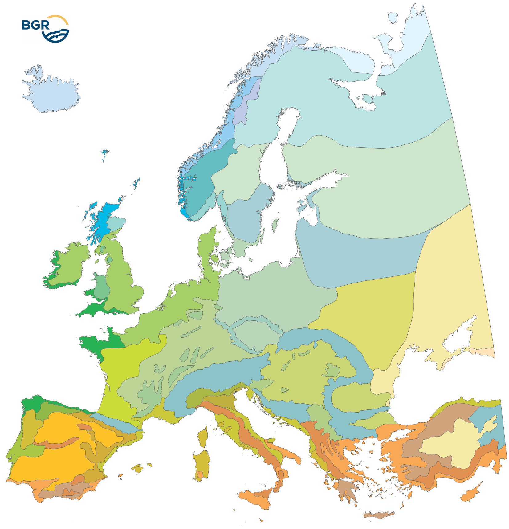
The Climatic Areas of Europe (EUCA15000) were delineated in order to stratify the legend of the European Soil Regions Map (EUSR5000). Because soil properties largely depend on climate, relief and geology, soil regions must be defined according to fairly homogenous macro-scale physiogeographic conditions. Because climate (and parent material) is the initial top level stratifier for the soil regions, its delineation is more coarsely defined. The EUCA15000 is mainly based on the Thermal Climate Classification (FAO 2004), which also has been used as a data source for the Global Agro-Ecological Zones (AEZ). Currently, the map distinguishes (i) the climate zones from North to South and (ii) the climate types with oceanic to continental influence. All in all, 35 climatic areas are delineated. They differ regarding mean annual temperatures, mean annual precipitation and the length of the growing period.
-
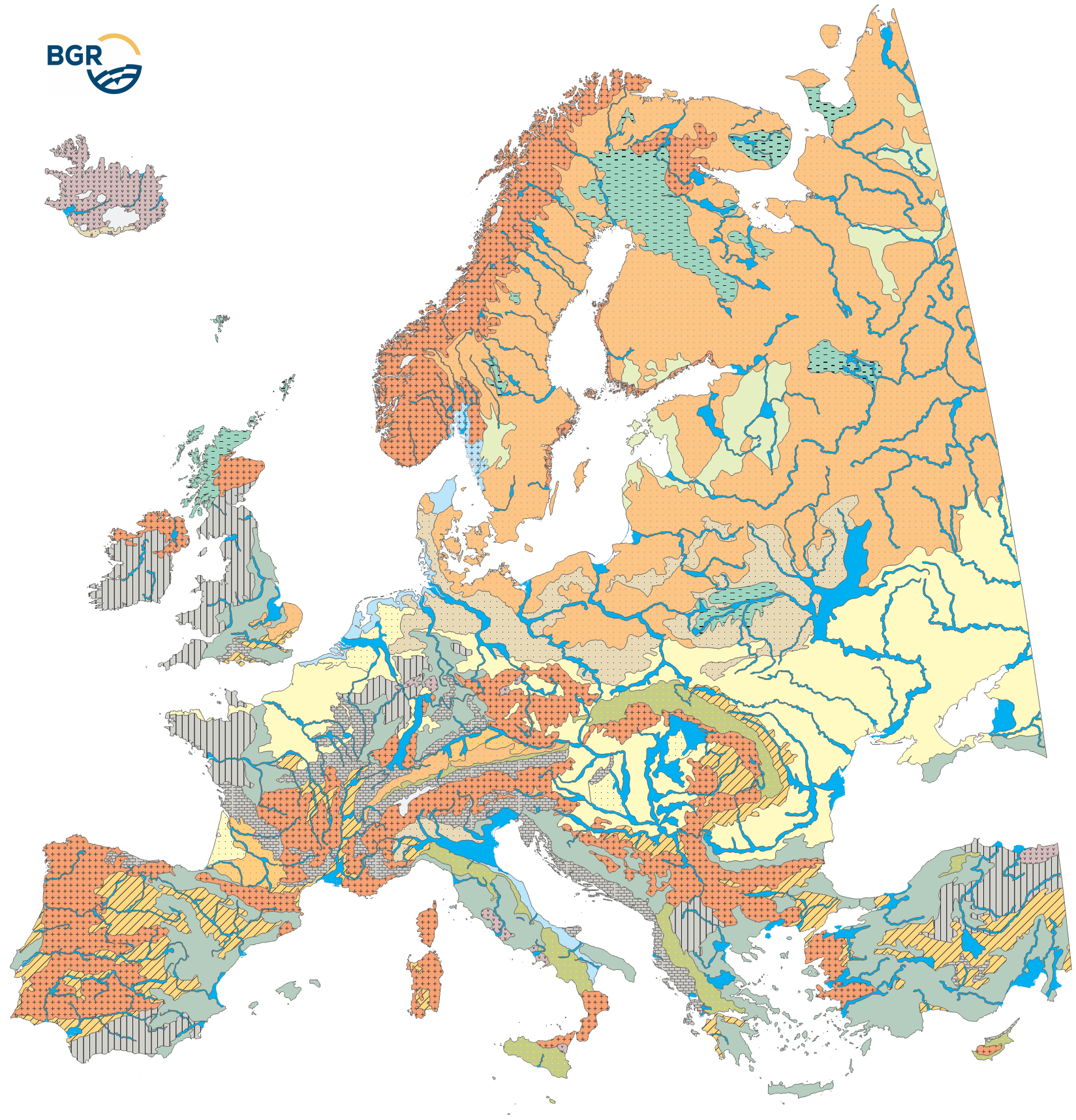
For the legend-building of the soil regions map (EUSR5000), areas with similar climate (EUCA15000) are further subdivided into areas with similar parent material, thus with a similar geologic paleogeographic development. Because the geological conditions (nature of parent material) are key factors for soil formation, it must be characterized at the level of the soil regions as well. In order to represent parent material at the Europe-wide continental level, data from small-scale geological maps were re-interpreted and aggregated to parent material associations 1:15 Mio. The different rocks are summarized by geological formation, at the same time following the main class- or group-level from the List of Parent Material according to Finke et al.(2001). As a result, 18 rock complexes were received and evaluated in respect of their effect on soil formation. Here it must be pointed out that soils are not formed on the rock itself but on weathering products mostly consisting of several layers and with numerous external components incorporated by redeposition.
-

Verbreitung der Arten aus den Anhängen II, IV und V der Fauna-Flora-HabitstRichtlinie (Richtlinie 92/43/EWG), transformiert ins INSPIRE-Datenmodell für das Thema "Verteilung der Arten" Die Angabe erfolgt auf Basis des EEA-Referenz-Gitters 10x10 km. Maßstab: 1:10000; Bodenauflösung: nullm; Scanauflösung (DPI): null
-

FFH-Lebensraumtypen nach Anhang I der Fauna-Flora-Habitat-Richtlinie (Richtlinie 92/43/EWG), transformiert ins INSPIRE-Datenmodell für das Thema "Lebensräume und Biotope" Maßstab: 1:10000; Bodenauflösung: nullm; Scanauflösung (DPI): null
-
.png)
FFH-Lebensraumtypen nach Anhang I der Fauna-Flora-Habitat-Richtlinie (Richtlinie 92/43/EWG), transformiert ins INSPIRE-Datenmodell für das Thema "Lebensräume und Biotope"
-
.png)
FFH-Lebensraumtypen nach Anhang I der Fauna-Flora-Habitat-Richtlinie (Richtlinie 92/43/EWG), transformiert ins INSPIRE-Datenmodell für das Thema "Lebensräume und Biotope" Maßstab: 1:10000; Bodenauflösung: nullm; Scanauflösung (DPI): null
-

Verbreitung der Arten aus den Anhängen II, IV und V der Fauna-Flora-HabitstRichtlinie (Richtlinie 92/43/EWG), transformiert ins INSPIRE-Datenmodell für das Thema "Verteilung der Arten" Die Angabe erfolgt auf Basis des EEA-Referenz-Gitters 10x10 km.
-

Aus- und Einfuhr (kalender- und saisonbereinigt)(Außenhandel): Deutschland, Monate, Länder und Ländergruppen
-
Aus- und Einfuhr (kalender- und saisonbereinigt)(Außenhandel): Deutschland, Monate, Länder und Ländergruppen