 My GeoNetwork catalogue
energy
Provided by
Type of resources
Available actions
Topics
Keywords
Contact for the resource
Update frequencies
Service types
-
-
-

-
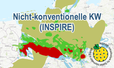
The WMS Nicht-konventionelle KW (INSPIRE) presents the results of the NiKo project according to data specifications Energy Resources (D2.8.III.20) und Geology (D2.8.II.4_v3.0). NiKo stands for „unconventional hydrocarbons“, „Nicht-konventionelle Kohlenwasserstoffe“ in German. In the NiKo project the Federal Institute for Geosciences and Natural Resources (BGR) has investigated the potential resources for shale oil and shale gas in Germany. The study was published in 2016 as a report titled „Schieferöl und Schiefergas in Deutschland – Ressourcen und Umweltaspekte“ (available in German only). The colloquial terms shale oil and shale gas refer to oil and natural gas resources in sedimentary shale rock formations, with high organic matter content. In the study, seven formations were identified to have a shale oil and/or gas potential in Germany and their distribution has been mapped in small scale. For each of the formations the organic-rich facies distribution is provided as layer and, if appropriate, the regional potential resource distribution: Fischschiefer (Oligocene), Blättertone (Barremium - Lower-Aptian), Wealden (Berriasium), Posidonienschiefer (Lower-Toarcium), Middel-Rhaetium (Oberkeuper), Permokarbon (Stefanium - Rotliegend) und Lower Carboniferous (Upper Alaunschiefer (Kulm-Facies) + Kohlenkalk-Facies). According to the overview maps in the report the following layers are provided, omitting however the sub-category “possible potential regions”. Bituminous facies distribution (0-5000 m depth) – data specification Geology: GE.GeologicUnit.Fischschiefer_distribution, GE.GeologicUnit.Blaettertone_distribution, GE.GeologicUnit.Wealden_distribution, GE.GeologicUnit.Posidonienschiefer_distribution, GE.GeologicUnit.Mittelrhaetium_black_shale_thicker_20m_distribution, GE.GeologicUnit.Permokarbon_black_shale_distribution, GE.GeologicUnit.Unterkarbon_Hangende_Alaunschiefer_distribution und GE.GeologicUnit.Unterkarbon_Kohlenkalk Facies layers are coloured according to the corresponding oldest formation age (olderNamedAge). Distribution shale oil and shale gas – potential resources (1000 - 5000 m depth) – data specification Energy Resources: ER.FossilFuelRessource.Blaettertone, ER.FossilFuelRessource.Wealden, ER.FossilFuelRessource.Posidonienschiefer, ER.FossilFuelRessource.Mittelrhaetschiefer, ER.FossilFuelRessource.Permokarbon und ER.FossilFuelRessource.Unterkarbon The shale oil and shale gas distribution layers are not coloured according to INSPIRE guidelines, but rather as common international practice in green and red, respectively. The distribution maps of the potential resources for shale oil and gas are based on geoscientific criteria. Further non-geoscientific limiting criteria, e.g. exclusion areas, have not been taken into account for the assessment. These assessments are based on appraisements of input parameters naturally with large uncertainties for the potential resources and their distribution in the deep underground. Based on the incipient exploration status of unconventionals in Germany, these resources are considered as undiscovered. The assessed shale oil and gas resources for Germany, represent the order of magnitude of potential resources. Source: BGR 2016 - Schieferöl und Schieferöl in Deutschland in 2016: - Potenziale und Umweltaspekte https://geoportal.bgr.de/mapapps/resources/apps/geoportal/index.html?lang=de#/datasets/portal/105160
-

-
Nicht-konventionelle KW (INSPIRE) presents the results of the NiKo project according to data specifications Energy Resources (D2.8.III.20) und Geology (D2.8.II.4_v3.0). NiKo stands for „unconventional hydrocarbons“, „Nicht-konventionelle Kohlenwasserstoffe“ in German. In the NiKo project the Federal Institute for Geosciences and Natural Resources (BGR) has investigated the potential resources for shale oil and shale gas in Germany. The study was published in 2016 as a report titled „Schieferöl und Schiefergas in Deutschland – Ressourcen und Umweltaspekte“ (available in German only). The colloquial terms shale oil and shale gas refer to oil and natural gas resources in sedimentary shale rock formations, with high organic matter content. In the study, seven formations were identified to have a shale oil and/or gas potential in Germany and their distribution has been mapped in small scale. For each of the formations the organic-rich facies distribution is provided and, if appropriate, the regional potential resource distribution: Fischschiefer (Oligocene), Blättertone (Barremium - Lower-Aptian), Wealden (Berriasium), Posidonienschiefer (Lower-Toarcium), Middel-Rhaetium (Oberkeuper), Permokarbon (Stefanium - Rotliegend) und Lower Carboniferous (Upper Alaunschiefer (Kulm-Facies) + Kohlenkalk-Facies). Corresponding to the overview maps in the report two GML-files for these layers are provided, omitting however the sub-category “possible potential regions”. Bituminous facies distribution (0-5000 m Tiefe) – data specification Geology: GeologicUnit.Distribution_of_bituminous_facies.gml Distribution shale oil and shale gas – potential resources (1000 - 5000 m Tiefe) – data specification Energy Resources: FossilFuelRessource_Potential_resource_regions.gml The distribution maps of the potential resources for shale oil and gas are based on geoscientific criteria. Further non-geoscientific limiting criteria, e.g. exclusion areas, have not been taken into account for the assessment. These assessments are based on appraisements of input parameters naturally with large uncertainties for the potential resources and their distribution in the deep underground. Based on the incipient exploration status of unconventionals in Germany, these resources are considered as undiscovered. The assessed shale oil and gas resources for Germany, represent the order of magnitude of potential resources. Reference: BGR 2016 - Schieferöl und Schieferöl in Deutschland- Potenziale und Umweltaspekte https://geoportal.bgr.de/mapapps/resources/apps/geoportal/index.html?lang=de#/datasets/portal/105160
-
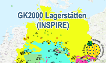
The WMS GK2000 Lagerstätten (INSPIRE) shows deposits and mines of energy resources, metal resources, industrial minerals and salt on a greatly simplified geology within Germany on a scale of 1:2,000,000. According to the Data Specification on Mineral Resources (D2.8.III.21) and Geology (D2.8.II.4_v3.0) the map provides INSPIRE-compliant data. The WMS GK2000 Lagerstätten (INSPIRE) contains the following layers: MR.Mine displays mines. MR.MineralOccurence.Commodity.Polygon.EnergyResources displays energy resources as polygons. GE.GeologicUnits provides the greatly simplified geology of Germany. For different geochronologic minimum and maximum ages, e.g. Precambrian - Cenozoic, the portrayal is defined by the colour of the geochronologic minimum age (olderNamedAge). The user obtains detailed information on the deposits, mines and geology via the getFeatureInfo request. Notes regarding the portrayal: The gas and oil provinces as well as the corresponding mines are coloured in green and red according to common international practice. The black coal fields are displayed in their original colour grey. The colouring of the brown coal fields correspond to the KOR250 respectively KOR250 (INSPIRE) colouring. All mine symbols and commodity abbrevations are BGR symbols and abbrevations.
-
The GK2000 Lagerstätten (INSPIRE) shows deposits and mines of energy resources, metal resources, industrial minerals and salt on a greatly simplified geology within Germany on a scale of 1:2,000,000. According to the Data Specifications on Mineral Resources (D2.8.III.21) and Geology (D2.8.II.4_v3.0) the content of the map is stored in three INSPIRE-compliant GML files: GK2000_Lagerstaetten_Mine.gml contains mines as points. GK2000_ Lagerstaetten _EarthResource_polygon_Energy_resources.gml contains energy resources as polygons. GK2000_ Lagerstaetten _GeologicUnit.gml contains the greatly simplified geology of Germany. The GML files together with a Readme.txt file are provided in ZIP format (GK2000_ Lagerstaetten -INSPIRE.zip). The Readme.text file (German/English) contains detailed information on the GML files content. Data transformation was proceeded by using the INSPIRE Solution Pack for FME according to the INSPIRE requirements.
-
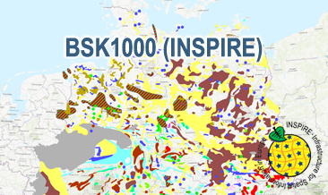
The WMS BSK1000 (INSPIRE) provides basic information on the spatial distribution of energy resources and mineral raw materials (‘stones and earth’, industrial minerals and ores) in Germany on a scale of 1:1,000,000. The BSK1000 is published by the Federal Institute for Geosciences and Natural Resources in cooperation with the State Geological Surveys of Germany. According to the Data Specification on Mineral Resources (D2.8.III.21) the map provides INSPIRE-compliant data. The WMS BSK1000 (INSPIRE) contains five layers: MR.Mine displays important mines. MR.MineralOccurence.Commodity.Point.EnergyResourcesAndMineralRawMaterials displays small-scale energy resources and mineral raw materials as points. MR.MineralOccurence.Commodity.Polygon.DistributionOfSalt displays the distribution of salt. MR.MineralOccurrence.Commodity.Polygon.EnergyResources displays large-scale energy resources as polygons. MR.MineralOccurrence.Commodity.Polygon.MineralRawMaterials displays large-scale mineral raw materials as polygons. The user obtains detailed information on the mineral raw materials, energy resources and mines via the getFeatureInfo request. Notes regarding the portrayal: The colouring of the large- and small-scale energy resources and mineral raw materials as well as of the mines corresponds largely to the colouring of the KOR250 respectively KOR250 (INSPIRE). In addition, the gas and oil polygons are coloured in green and red according to common international practice. The black coal polygons are displayed in their original colour grey. Also the colours of the mine symbols correspond largely to the KOR250 respectively KOR250 (INSPIRE) colouring. Only the salt and potash mine symbols have their original colour. All mine symbols are BGR symbols. The distribution areas of the Triassic and Zechstein salt show the corresponding geochronological INSPIRE colours (see Data Specification on Geology D2.8.II.4_v3.0). The distribution area of salt diapirism is displayed in a BGR colour.
-
The BSK1000 (INSPIRE) provides the basic information on the spatial distribution of energy resources and mineral raw materials (‘stones and earth’, industrial minerals and ores) in Germany on a scale of 1:1,000,000. The BSK1000 is published by the Federal Institute for Geosciences and Natural Resources in cooperation with the State Geological Surveys of Germany. According to the Data Specification on Mineral Resources (D2.8.III.21) the content of the map is stored in five INSPIRE-compliant GML files: BSK1000_Mine.gml contains important mines as points. BSK1000_EarthResource_point_Energy_resources_and_mineral_raw_materials.gml contains small-scale energy resources and mineral raw materials as points. BSK1000_EarthResource_polygon_Distribution_of_salt.gml contains the distribution of salt as polygons. BSK1000_EarthResource_polygon_Energy_resources.gml contains large-scale energy resources as polygons. BSK1000_EarthResource_polygon_Mineral_raw_materials.gml contains large-scale mineral raw materials as polygons. The GML files together with a Readme.txt file are provided in ZIP format (BSK1000-INSPIRE.zip). The Readme.text file (German/English) contains detailed information on the GML files content. Data transformation was proceeded by using the INSPIRE Solution Pack for FME according to the INSPIRE requirements.