 My GeoNetwork catalogue
Germany
Provided by
Type of resources
Available actions
Topics
Keywords
Contact for the resource
Update frequencies
Service types
-
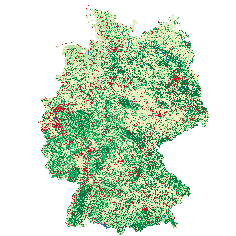
This land cover classification of Germany was created using Sentinel-2 imagery from the years 2015 to 2017 and LUCAS 2015 in-situ reference data (https://ec.europa.eu/eurostat/web/lucas). It contains seven land cover types: (1) artificial land, (2) open soil, (3) high seasonal vegetation, (4) high perennial vegetation, (5) low seasonal vegetation, (6) low perennial vegetation and (7) water with a spatial resolution of 10m x 10m. For further information, please see the following publication: https://doi.org/10.1016/j.jag.2020.102065
-
The WWDL38 TTAAii Data Designators decode as: T1 (W): Warnings T1T2 (WW): Warnings and weather summary A1A2 (DL): Germany (Remarks from Volume-C: NilReason)
-
The WWDL38 TTAAii Data Designators decode as: T1 (W): Warnings T1T2 (WW): Warnings and weather summary A1A2 (DL): Germany (Remarks from Volume-C: NilReason)
-
The WWDL39 TTAAii Data Designators decode as: T1 (W): Warnings T1T2 (WW): Warnings and weather summary A1A2 (DL): Germany (Remarks from Volume-C: NilReason)
-
The WWDL39 TTAAii Data Designators decode as: T1 (W): Warnings T1T2 (WW): Warnings and weather summary A1A2 (DL): Germany (Remarks from Volume-C: NilReason)
-
The WWDL39 TTAAii Data Designators decode as: T1 (W): Warnings T1T2 (WW): Warnings and weather summary A1A2 (DL): Germany (Remarks from Volume-C: NilReason)
-
The WWDL99 TTAAii Data Designators decode as: T1 (W): Warnings T1T2 (WW): Warnings and weather summary A1A2 (DL): Germany (Remarks from Volume-C: NilReason)
-
The WWDL39 TTAAii Data Designators decode as: T1 (W): Warnings T1T2 (WW): Warnings and weather summary A1A2 (DL): Germany (Remarks from Volume-C: NilReason)
-
The WWDL39 TTAAii Data Designators decode as: T1 (W): Warnings T1T2 (WW): Warnings and weather summary A1A2 (DL): Germany (Remarks from Volume-C: NilReason)
-
The WWDL38 TTAAii Data Designators decode as: T1 (W): Warnings T1T2 (WW): Warnings and weather summary A1A2 (DL): Germany (Remarks from Volume-C: NilReason)