 My GeoNetwork catalogue
monitoring
Provided by
Type of resources
Topics
Keywords
Contact for the resource
Update frequencies
-
-
-
-
-
-
-
-
-
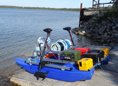
Lake Runstedt, around 30 km west of Leipzig, is a post-mining lake created by the flooding of the former Großkayna open-cast mine. After the end of the lignite mining, the pit was partially filled with industrial waste and fly ash for several decades. With high concentrations of ammonium in the sediment, oxygen consumption due to nitrification of ammonium released into the lake is a major challenge to the lake’s water quality. To ensure the oxygen supply in the hypolimnion (i.e. the bottom lake layer that is not affected by wind mixing) in summer, three aerators are operated in the lake by the Lausitzer und Mitteldeutsche Bergbau-Verwaltungsgesellschaft (LMBV). In 2023, the Freiberg University of Mining and Technology was commissioned by the BGR to carry out three measurement campaigns (end of July/beginning of August, mid-September, mid-October) on the lake using an autonomous surface vehicle (here: a catamaran-shaped robotic device) to assess the spatial effects of the aeration on lake water quality. The data set provided contains the collected three-dimensional data of water temperature, oxygen content, pH, electrical conductivity, turbidity and chlorophyll. In addition, laboratory analyses of water samples obtained with a Ruttner sampler are included. The data reflect the conditions before and after operation of the aerators. Detailed explanations can be found in the publication “Spatial heterogeneity of dissolved oxygen and sediment fluxes revealed by autonomous robotic lakewater profiling” (2025) by Röder et al. in the journal Limnology and Oceanography (http://doi.org/10.1002/lno.70174).
-
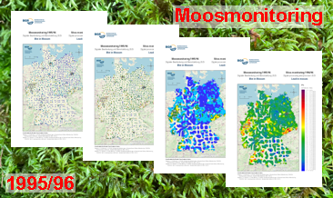
In the Federal Republic of Germany, analyses to determine the constituents of mosses were carried out at five-year intervals from 1990 to 2005 and in 2015/16 and 2020/21. The focus was on analysing heavy metals, and from 2005/06 also nitrogen. Since 2015/16, the range of substances has been expanded to include persistent organic pollutants (POPs) and microplastics. This moss monitoring is the German contribution to the European moss monitoring programme, which is coordinated by the ‘International Cooperative Programme on Effects of Air Pollution on Natural Vegetation and Crops’ (ICP Vegetation) of the Geneva Convention on Long-range Transboundary Air Pollution (CLRTAP). The German Environment Agency (Umweltbundesamt - UBA) has commissioned various institutions to carry out the individual sampling campaigns and analyse the results of the investigations, including the Federal Institute for Geosciences and Natural Resources (BGR) for moss monitoring in 1995/96. The UBA has published the results of subsequent monitoring years. They are available at https://www.umweltbundesamt.de/daten/luft/bioindikation-von-luftverunreinigungen. With 1026 sites, the 1995/96 moss monitoring is, alongside the 2000 moss monitoring, the one with the greatest sample density and, with 40 analysed elements, the one with the widest range of investigations. Although the research reports completed in 1998 and 1999 (Siewers & Herpin, 1998; Siewers, Herpin & Straßburg, 1999) contained an evaluation (brief description, statistical measures, distribution maps) of all 40 elements analysed, only the data of 12 of the analysed elements have been published to date. In addition, the raw data from the laboratories available as a result of the analyses were re-evaluated in 2007. This resulted in a series of error corrections and the analysable element spectrum was extended to 42 elements. The results of this re-evaluation have also not yet been published. The additional processing of the data using modern methods has further enhanced their value. The downloads show the distribution of selenium concentrations in four different coloured dot and colour shaded contour maps. The legends of the maps can be called up either in the unit of measurement µg/g or in a unit of measurement adapted to the content range of the element shown.