 My GeoNetwork catalogue
EU
Provided by
Type of resources
Topics
Keywords
Contact for the resource
Update frequencies
Service types
-
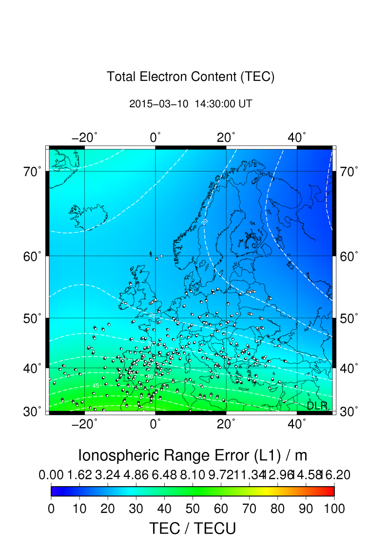
SWACI is a research project of DLR supported by the State Government of Mecklenburg-Vorpommern. Radio signals, transmitted by modern communication and navigation systems may be heavily disturbed by space weather hazards. Thus, severe temporal and spatial changes of the electron density in the ionosphere may significantly degrade the signal quality of various radio systems which even may lead to a complete loss of the signal. By providing specific space weather information, in particular now- and forecast of the ionospheric state, the accuracy and reliability of impacted communication and navigation systems shall be improved. The total electron content (TEC) is defined as the integral of the electron density along the ray path between satellite and receiver. Thus, TEC provides the number of electrons per square meter. The most frequently used unit is 1TECU = 1x10¹⁶ electrons / m2. TEC is derived from dual frequency code and carrier phase measurements provided by Global Navigation Satellite Systems (GNSS). SWACI uses GPS measurements from various European GNSS networks such as the International GNSS Service (IGS), European Reference Frame (EUREF), Norwegian Mapping Authority (NMA), and ascos distributed by the Federal Agency of Cartography and Geodesy (BKG) Frankfurt. The global TEC maps are mainly created by using data provided by the International GNSS Service Real-Time Pilot Project (IGS-RTPP). To generate TEC maps of vertical TEC, the slant measurements have to be transformed to the vertical. In a first approximation the ionospheric range error in GNSS is proportional to TEC. These TEC maps are used to derive latitudinal and zonal gradients, rate of change of TEC (5 min increments), 27 days medians, hourly forecasts of TEC, and corresponding error estimates. Spatial resolution (latitude x longitude): 2 °x 2° (Europe), 2.5° x 5° (globally)
-
Der Datensatz zeigt die Standorte der europaaktiven Institutionen und Vereine in Düsseldorf.
-

EU-relevantes Gewässernetz (WRRL) Landkreis Diepholz auf Basis DGK5; Bestandsaufnahme zur Umsetzung der EU-Wasserrahmenrichtlinie ---- Den Downloadservice zu diesem Thema finden Sie unter DOWNLOAD-LINKS ----
-

Feldberegnungsflächen Landkreis Diepholz auf Basis ALKIS; Beregnungsflächen laut Angabe der Antragsteller; Flächen auf denen eine Beregnung (Feldberegnung, Sportplätze, Gartenbau, sonstige) durchgeführt wird ---- Den Downloadservice zu diesem Thema finden Sie unter DOWNLOAD-LINKS ----
-
Der Datensatz enthält Daten zu den nach Düsseldorf geflossenen Fördermitteln der EU. Die Daten stammen aus verschiedenen Ministerien und wurden vom Büro für Internationale und Europäische Angelegenheiten aufbereitet und betreffen die Förderperiode 2014 bis 2019.
-
Dieses Faltblatt gibt einen Überblick über die raumordnerische Zusammenarbeit der Ostseeanrainerstaaten.
-
Dieser Dienst enthält die Daten zu den nach Düsseldorf geflossenen Fördermitteln der EU sowie die Standorte der europaaktiven Institutionen und Vereine in Düsseldorf.
-
Die Strategischen Lärmkarten 2012 geben Auskunft über die Lärmbelastung im Einwirkbereich von Hauptlärmquellen. Sie sind eine Fortführung der Strategischen Lärmkarten 2007. Das Eisenbahn-Bundesamt hat die Lärmkartierung der Eisenbahnen des Bundes nach dem Allgemeinem Eisenbahngesetz (AEG) selbständig durchgeführt.
-
Trinkwasserbericht NRW (2023) – 2 pdf-Dateien („DWD_2023_DENW_DWD_1000“ und „DWD_2023_DENW_TrinkwV_10“) Die Trinkwasserrichtlinie (EU) 2020/2184 verpflichtet die Mitgliedstaaten zur Berichterstattung über die Qualität des Trinkwassers, wobei die Berichtspflicht für Versorgungsgebiete gilt, die täglich mehr als 1.000 m³ Trinkwasser liefern oder mehr als 5.000 Personen versorgen. Gemäß § 69 TrinkwV sind die Gesundheitsämter dazu verpflichtet, jedes Jahr einen Datensatz über die Qualität des Trinkwassers des vorangegangenen Kalenderjahres an die dafür vorgesehene oberste Landesbehörde oder eine andere nach Landesrecht (in diesem Fall das LANUK) zuständige Stelle zu übermitteln. Dieser beinhaltet die Bewertung der Trinkwasserqualität in Versorgungsgebieten, die eine tägliche Abgabe von mindestens 10 Kubikmetern Trinkwasser oder die Versorgung von mindestens 50 Personen gewährleisten. Im weiteren Prozess erstellt das LANUK aus diesem Datensatz den zusammenfassenden DWD-Bericht („DWD_2023_DENW_DWD_1000“ und „DWD_2023_DENW_TrinkwV_10“), welcher anschließend an das Bundesministerium für Gesundheit übermittelt wird. Die hier ausgestellten DWD-Berichte sind eine aggregierte Zusammenfassung der Trinkwasserdaten aus dem Berichtsjahr 2023. Diese Zusammenfassung ist aufgeteilt in 2 pdf-Dateien: A: „DWD_2023_DENW_DWD_1000“ mit den Daten zu Versorgungsgebieten, die mehr als 1000 m³ pro Tag liefern B: „DWD_2023_DENW_TrinkwV_10“ mit den Daten zu Versorgungsgebieten, die zwischen 10 und 1000 m³ pro Tag liefern. Die beiden Dateien beinhalten folgende Tabellenblättern mit den Daten zu: 1. Nicht eingehaltene Überwachungshäufigkeiten. 2. Allgemeine Informationen über die Rahmenbedingungen der Trinkwasserversorgung in dem Land. 3. Zusammenfassende Informationen über die Qualität von Wasser für den menschlichen Gebrauch in den WVG. 4. Information über die Ergebnisse der Nachforschungen bei Nichteinhaltung des Parameterwertes Clostridium perfringens. 5. Informationen über Nichteinhaltung der Parameterwerte bei Wasser für den menschlichen Gebrauch in WVG. 6. Informationen über Einschränkung/Unterbrechung der Bereitstellung von Wasser für den menschlichen Gebrauch wegen Nichteinhaltung der Parameterwerte im WVG. 7. Informationen über Ursachen der Nichteinhaltung der Parameterwerte im WVG. 8. Informationen über Abhilfemaßnahmen bei Nichteinhaltung der Parameterwerte im WVG. 9. Informationen über die produktspezifischen Parameter Acrylamid, Epichlorhydrin und Vinylchlorid 10. Art der im Land öffentlich zugänglichen Informationen. 11. Kommunikation der im Land verfügbaren Informationen über die Qualität von Wasser für den menschlichen Gebrauch. 12. Informationen über die Wasserversorgungsgebiete in dem Land. 13. Informationen über Änderungen der Wasserversorgungsgebiete in dem Land. 14. Codes für den Zeitrahmen bei Einschränkung oder Unterbrechung der Bereitstellung von Wasser für den menschlichen Gebrauch. 15. Codes für die Ursachen einer Nichteinhaltung. 16. Codes für Abhilfemaßnahmen bei Nichteinhaltung. 17. Codes für den Zeitrahmen der Abhilfemaßnahmen.
-
Ruhige Gebiete im Sinne der Umgebungslärmrichtlinie sind große, zusammenhängende Freiflächen, teilweise auch in Verbindung mit ballungsraumübergreifenden Verbindungen in benachbarte Landschaftsräume, die geringe Lärmpegel aufweisen. Da die ruhigen Gebiete vorrangig die zentrumsfernen Areale abdecken, hat der Lärmaktionsplan eine zweite Kategorie mit innerstädtischen Erholungsflächen gebildet. Sie haben aber eine hohe Aufenthaltsfunktion und sind in ihrer Kernfläche deutlich leiser als an ihrer Peripherie.