 www.geodatenkatalog.de (S1L)
Keyword
Mineralien
51 record(s)
Provided by
Type of resources
Available actions
Topics
Keywords
Contact for the resource
Service types
-
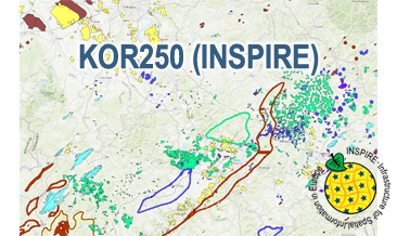
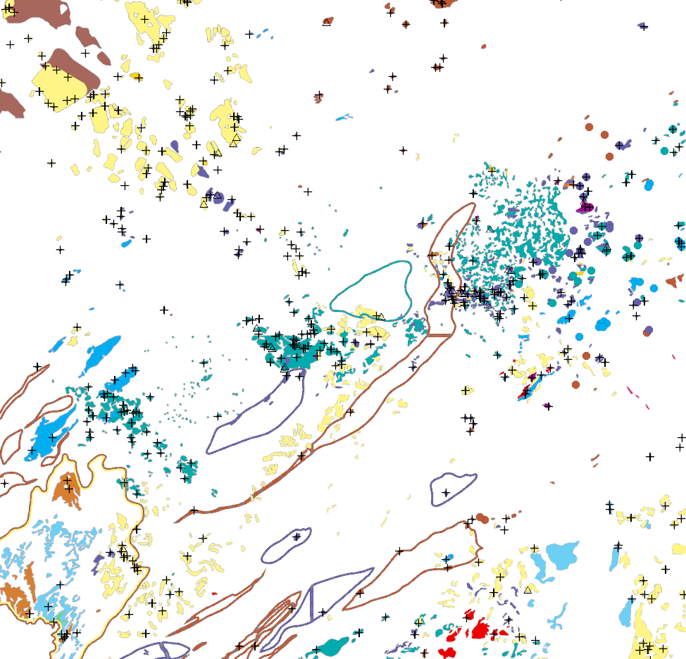
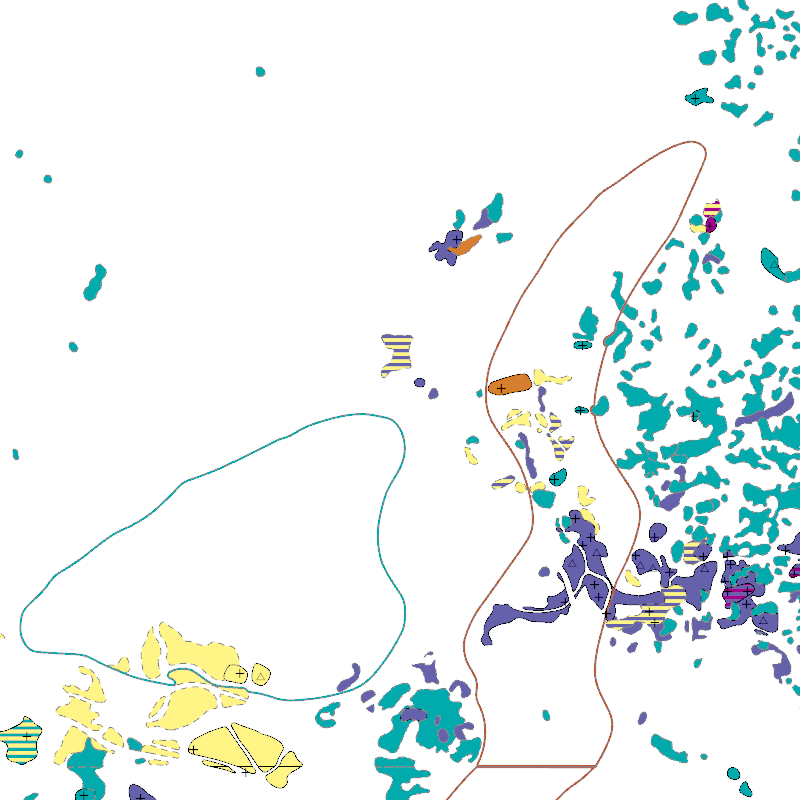
The WMS KOR250 (INSPIRE) in the scale of 1:250,000 shows occurrences and deposits of mineral resources in Germany, which lie close to the Earth’s surface, i.e. can be mined in open-pits, quarries or near-surface mines. These mineral resources include industrial minerals, aggregates, peat, lignite, oil shales, and natural brines. The map is derived from the KOR250, the digital successor of the map series KOR200 „Map of Near-Surface Deposits of the Federal Republic of Germany 1:200,000”, which has been published since 1984. The KOR200 and KOR250 have been published by the Federal Institute for Geosciences and Natural Resources together with the State Geological Surveys of the federal states on behalf of the Federal Ministry for Economic Affairs and Energy. Primary purpose of the KOR250 is to display Germany’s potential of domestic raw materials in a comparable way. The explanations given in the printed booklets accompanying the KOR200 are not available in the digital KOR250. In the KOR250 besides the defined deposits and differently coloured areas of raw materials, "active mines" (= operations) at time of publication or "focal points of several active mines" are marked with one symbol each. These mines are not included in the KOR250 (INSPIRE) as often the headquarters of the mining company and not the mining site itself is displayed as well as in many regions the dataset is outdated. As the map sheets of the KOR200 have been generated over more than three decades the timeliness of data is extremely different. For more detail, the current large-scale raw material maps of the Federal State Geological Surveys should always be consulted. The point data displayed in KOR250 (INSPIRE) indicate very small, but worth mentioning prospects of certain raw materials. The WMS KOR250 (INSPIRE) contains the two layers MR.MineralOccurence.Commodity.Polygon (mineral resources as polygons) and MR.MineralOccurence.Commodity.Point (mineral resources as points). Via the getFeatureInfo request the user obtains additional information on the mineral resources. Notes: The colouring of the raw material occurrences in the KOR250 (INSPIRE) largely corresponds to the colouring of the original KOR250. In the INSPIRE Data Specification on Mineral Resources (D2.8.III.21) there are no portrayal rules for building raw materials and dimension stones, which constitute a large part of the raw material occurrences. It should be noted that according to the INSPIRE commodity code list, most magmatites and metamorphites were assigned to the two values "granite" and "basalt". From a geological point of view and with regard to its origin, this assignment is often misleading. For more information on the outcropping rock of a specific raw material occurrence, the German name from the original KOR250 was mapped to the attribute name of the class GeologicFeature. Link KOR200: https://www.bgr.bund.de/EN/Themen/Min_rohstoffe/Projekte/Rohstoffverfuegbarkeit_laufend_en/KOR_200_en.html
-
The KOR250 (INSPIRE) in the scale of 1:250,000 shows occurrences and deposits of mineral resources in Germany, which lie close to the Earth’s surface, i.e. can be mined in open-pits, quarries or near-surface mines. These mineral resources include industrial minerals, aggregates, peat, lignite, oil shales, and natural brines. The map is derived from the KOR250, the digital successor of the map series KOR200 „Map of Near-Surface Deposits of the Federal Republic of Germany 1:200,000”, which has been published since 1984. The KOR200 and KOR250 have been published by the Federal Institute for Geosciences and Natural Resources together with the State Geological Surveys of the federal states on behalf of the Federal Ministry for Economic Affairs and Energy. Primary purpose of the KOR250 is to display Germany’s potential of domestic raw materials in a comparable way. The explanations given in the printed booklets accompanying the KOR200 are not available in the digital KOR250. In the KOR250 besides the defined deposits and differently coloured areas of raw materials, "active mines" (= operations) at time of publication or "focal points of several active mines" are marked with one symbol each. These mines are not included in the KOR250 (INSPIRE) as often the headquarters of the mining company and not the mining site itself is displayed as well as in many regions the dataset is outdated. As the map sheets of the KOR200 have been generated over more than three decades the timeliness of data is extremely different. For more detail, the current large-scale raw material maps of the Federal State Geological Surveys should always be consulted. The point data displayed in KOR250 (INSPIRE) indicate very small, but worth mentioning prospects of certain raw materials. According to the Data Specification on Mineral Resources (D2.8.III.21) the content of the map is stored in two INSPIRE-compliant GML files: KOR250_EarthResource_polygon.gml comprises the mineral resources as polygons. KOR250_EarthResource_point.gml comprises the mineral resources as points. The GML files together with a Readme.txt file are provided in ZIP format (KOR250-INSPIRE.zip). The Readme.text file (German/English) contains detailed information on the GML files content. Data transformation was proceeded by using the INSPIRE Solution Pack for FME according to the INSPIRE requirements. Notes: It should be noted that according to the INSPIRE commodity code list, most magmatites and metamorphites were assigned to the two values "granite" and "basalt". From a geological point of view and with regard to its origin, this assignment is often misleading. For more information on the outcropping rock of a specific raw material occurrence, the German name from the original KOR250 was mapped to the attribute name of the class GeologicFeature. Link KOR200: https://www.bgr.bund.de/EN/Themen/Min_rohstoffe/Projekte/Rohstoffverfuegbarkeit_laufend_en/KOR_200_en.html
-
The KOR250 in the scale of 1:250,000 shows occurrences and deposits of mineral resources in Germany, which lie close to the Earth’s surface, i.e. can be mined in open-pits, quarries or near-surface mines. These mineral resources include industrial minerals, aggregates, peat, lignite, oil shales, and natural brines. The map is the digital successor of the map series KOR200 „Map of Near-Surface Deposits of the Federal Republic of Germany 1:200,000”, which has been published since 1984. The KOR200 and KOR250 have been published by the Federal Institute for Geosciences and Natural Resources together with the State Geological Surveys of the federal states on behalf of the Federal Ministry for Economic Affairs and Energy. Primary purpose of the KOR250 is to display Germany’s potential of domestic raw materials in a comparable way. The explanations given in the printed booklets accompanying the KOR200 are not available in the digital KOR250. In the KOR250 besides the defined deposits and differently coloured areas of raw materials, "active mines" (= operations) at time of publication or "focal points of several active mines" are marked with one symbol each. These symbols often display the headquarters of the mining company and not the mining site itself. As the map sheets of the KOR200 have been generated over more than three decades the timeliness of data is extremely different. For more detail, the current large-scale raw material maps of the Federal State Geological Surveys should always be consulted.
-
Geologie erleben - Museen, Schauhöhlen, Besucherbergwerke, Lehr- und Wanderpfade in NRW und Umgebung
Mit einer Fülle an Informationen stellt der bebilderte Museumsführer des Geologischen Dienstes von Nordrhein-Westfalen über 300 geowissenschaftlich besonders interessante Museen, Schauhöhlen, Besucherbergwerke sowie geologische und montanhistorische Lehr- und Wanderpfade in NRW vor. Zusätzlich sind zahlreiche Geo-Museen aus der benachbarten Umgebung in Niedersachsen, Hessen, Rheinland-Pfalz, den Niederlanden und Belgien mit aufgenommen. [2006. 2. völlig überarbeitete und aktualisierte Auflage, 127 S., zahlr. Abb., 1 Übersichtskarte; ISBN 978-3-86029-970-8]. Die Publikation ist derzeit nur in gedruckter Form erhältlich.
-
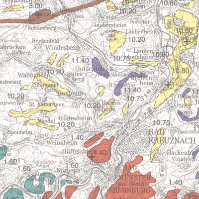
In order to exploit mineral raw materials close to the Earth's surface, experts are working on trans-regional and national planning documents. To do this, they need maps which clearly depict the raw materials close to the surface in Germany. KOR200 displays Germany's national raw material potential in a comparable way, thus forming a basis for future exploration and investigations as well as making a contribution towards the assurance of the supply of raw materials. The map follows the sheet line system of the topographical survey map 1:200.000 (TÜK 200) and consists of 55 sheets, each with an explanatory booklet. There is a review of the current situation, a description, a depiction and documentation of the occurrence and deposits of mineral raw materials which are usually extracted in mines either on or close to the Earth's surface. Such deposits include, in particular, industrial minerals, rocks and soils, peat, lignite, oil shale and brines. Besides the delimited deposits and areas of raw materials coloured according to the raw material in question, the maps also depict "mining areas" (=operations) or "focal points of several mining areas", each marked with a symbol. The map entries are - just as with the topographical basis - recorded in digitalised form in a databank, from which they can be retrieved via a computer using various search criteria. The entries in the map are supplemented by between 40 to 80 pages of textual explanations, which are currently available only in the printed edition of the map. The text is divided into: - introduction - description of the deposits and occurrence of useful rocks - supply and demand assessment of the deposits and occurrence of raw materials close to the Earth's surface in the area covered by the sheet - possible ways of using the useful rocks present in the sheet area - list of publications - appendix (with, amongst other things, a general legend and survey of sheets)
-
The KOR250 in the scale of 1:250,000 shows occurrences and deposits of mineral resources in Germany, which lie close to the Earth’s surface, i.e. can be mined in open-pits, quarries or near-surface mines. These mineral resources include industrial minerals, aggregates, peat, lignite, oil shales, and natural brines. The map is the digital successor of the map series KOR200 „Map of Near-Surface Deposits of the Federal Republic of Germany 1:200,000”, which has been published since 1984. The KOR200 and KOR250 have been published by the Federal Institute for Geosciences and Natural Resources together with the State Geological Surveys of the federal states on behalf of the Federal Ministry for Economic Affairs and Energy. Primary purpose of the KOR250 is to display Germany’s potential of domestic raw materials in a comparable way. The explanations given in the printed booklets accompanying the KOR200 are not available in the digital KOR250. In the KOR250 besides the defined deposits and differently coloured areas of raw materials, "active mines" (= operations) at time of publication or "focal points of several active mines" are marked with one symbol each. These symbols often display the headquarters of the mining company and not the mining site itself. As the map sheets of the KOR200 have been generated over more than three decades the timeliness of data is extremely different. For more detail, the current large-scale raw material maps of the Federal State Geological Surveys should always be consulted.
-
In order to exploit mineral raw materials close to the Earth's surface, experts are working on trans-regional and national planning documents. To do this, they need maps which clearly depict the raw materials close to the surface in Germany. KOR200 displays Germany's national raw material potential in a comparable way, thus forming a basis for future exploration and investigations as well as making a contribution towards the assurance of the supply of raw materials. The map follows the sheet line system of the topographical survey map 1:200.000 (TÜK 200) and consists of 55 sheets, each with an explanatory booklet. There is a review of the current situation, a description, a depiction and documentation of the occurrence and deposits of mineral raw materials which are usually extracted in mines either on or close to the Earth's surface. Such deposits include, in particular, industrial minerals, rocks and soils, peat, lignite, oil shale and brines. Besides the delimited deposits and areas of raw materials coloured according to the raw material in question, the maps also depict "mining areas" (=operations) or "focal points of several mining areas", each marked with a symbol. The map entries are - just as with the topographical basis - recorded in digitalised form in a databank, from which they can be retrieved via a computer using various search criteria. The entries in the map are supplemented by between 40 to 80 pages of textual explanations, which are currently available only in the printed edition of the map. The text is divided into: - introduction - description of the deposits and occurrence of useful rocks - supply and demand assessment of the deposits and occurrence of raw materials close to the Earth's surface in the area covered by the sheet - possible ways of using the useful rocks present in the sheet area - list of publications - appendix (with, amongst other things, a general legend and survey of sheets)
-
In order to exploit mineral raw materials close to the Earth's surface, experts are working on trans-regional and national planning documents. To do this, they need maps which clearly depict the raw materials close to the surface in Germany. KOR200 displays Germany's national raw material potential in a comparable way, thus forming a basis for future exploration and investigations as well as making a contribution towards the assurance of the supply of raw materials. The map follows the sheet line system of the topographical survey map 1:200.000 (TÜK 200) and consists of 55 sheets, each with an explanatory booklet. There is a review of the current situation, a description, a depiction and documentation of the occurrence and deposits of mineral raw materials which are usually extracted in mines either on or close to the Earth's surface. Such deposits include, in particular, industrial minerals, rocks and soils, peat, lignite, oil shale and brines. Besides the delimited deposits and areas of raw materials coloured according to the raw material in question, the maps also depict "mining areas" (=operations) or "focal points of several mining areas", each marked with a symbol. The map entries are - just as with the topographical basis - recorded in digitalised form in a databank, from which they can be retrieved via a computer using various search criteria. The entries in the map are supplemented by between 40 to 80 pages of textual explanations, which are currently available only in the printed edition of the map. The text is divided into: - introduction - description of the deposits and occurrence of useful rocks - supply and demand assessment of the deposits and occurrence of raw materials close to the Earth's surface in the area covered by the sheet - possible ways of using the useful rocks present in the sheet area - list of publications - appendix (with, amongst other things, a general legend and survey of sheets)