 My GeoNetwork catalogue
World-wide
Provided by
Type of resources
Available actions
Topics
Keywords
Contact for the resource
Service types
-
The World-wide Hydrogeological Map Information System (WHYMIS) offers information on the availability of hydrogeological and other groundwater related maps at national (country) and international (continent) level.
-
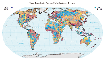
The World-wide Hydrogeological Mapping and Assessment Programme (WHYMAP) provides data and information about the earth´s major groundwater resources. The Map of Global Groundwater Vulnerability to Floods and Droughts indicates the vulnerability level of groundwater resources of the earth. It presents the intrinsic vulnerability of groundwater systems and the sensitivity or resistance of those systems to natural disasters.
-
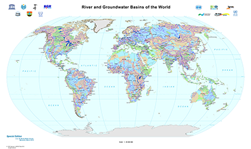
The World-wide Hydrogeological Mapping and Assessment Programme (WHYMAP) provides data and information about the earth´s major groundwater resources. The River and Groundwater Basins Map shows the areal extent of the global groundwater and surface water basins.
-
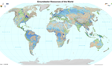
The World-wide Hydrogeological Mapping and Assessment Programme (WHYMAP) provides data and information about the earth´s major groundwater resources. The Groundwater Resources Map shows various characteristic groundwater environments in their areal extent and classified by their aquifer productivity and recharge potential. Additional groundwater related features such as wetlands and areas of low rainfall are included in the dataset.
-
The World-wide Hydrogeological Mapping and Assessment Programme (WHYMAP) provides data and information about the earth´s major groundwater resources. The Map of Global Groundwater Vulnerability to Floods and Droughts indicates the vulnerability level of groundwater resources of the earth. It presents the intrinsic vulnerability of groundwater systems and the sensitivity or resistance of those systems to natural disasters.
-
The World-wide Hydrogeological Mapping and Assessment Programme (WHYMAP) provides data and information about the earth´s major groundwater resources. The Groundwater Resources Map shows various characteristic groundwater environments in their areal extent and classified by their aquifer productivity and recharge potential. Additional groundwater related features such as wetlands and areas of low rainfall are included in the dataset.
-
The World-wide Hydrogeological Map Information System (WHYMIS) offers information on the availability of hydrogeological and other groundwater related maps at national (country) and international (continent) level.
-
The World-wide Hydrogeological Mapping and Assessment Programme (WHYMAP) provides data and information about the earth´s major groundwater resources. The River and Groundwater Basins Map shows the areal extent of the global groundwater and surface water basins.
-
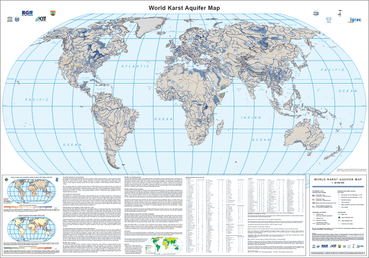
The World-wide Hydrogeological Mapping and Assessment Programme (WHYMAP) provides data and information about the earth´s major groundwater resources. The World Karst Aquifer Map (WOKAM) allows a more precise global quantification of karst systems. The map will help to increase awareness of karst groundwater resources in the context of global water issues and will serve as a basis for other karst-related research questions at global scales: for example those related to climate change, biodiversity, food production, geochemical cycles and urbanisation.
-
The World-wide Hydrogeological Mapping and Assessment Programme (WHYMAP) provides data and information about the earth´s major groundwater resources. The World Karst Aquifer Map (WOKAM) allows a more precise global quantification of karst systems. The map will help to increase awareness of karst groundwater resources in the context of global water issues and will serve as a basis for other karst-related research questions at global scales: for example those related to climate change, biodiversity, food production, geochemical cycles and urbanisation.