 My GeoNetwork catalogue
Geology
Provided by
Type of resources
Available actions
Topics
Keywords
Contact for the resource
Update frequencies
Service types
-
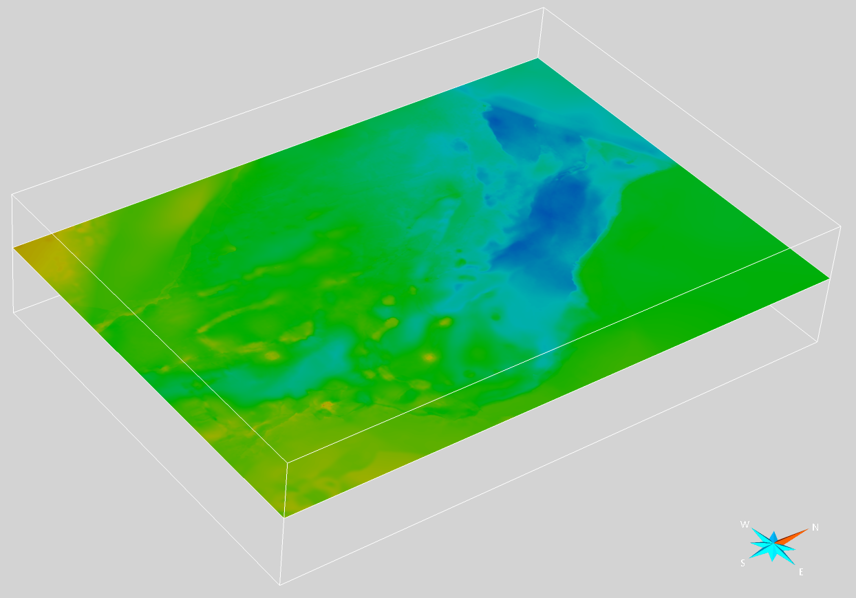
Within the GeoEra research project "3D Geomodeling for Europe” (3DGEO-EU, 2018-2021), a harmonized cross-border seismic velocity model for time-depth conversion was developed, covering main parts of the Danish, German, and northern Dutch North Sea. The model was created through collaboration between the Netherlands Organization for Applied Scientific Research (TNO, NL), the Geological Survey of Denmark and Greenland (GEUS, DK) and the Federal Institute for Geosciences and Natural Resources (BGR, GER). The transnational velocity model combines a V0-K layer-cake velocity model for Cenozoic and Mesozoic units with a Vint-DeltaT velocity model used for the Zechstein interval. In total, seven main stratigraphic layers were selected by the project partners to build the velocity model. As input data, velocity information gathered from 724 wells was used. For the Entenschnabel region covering the northwestern part of the German North Sea sector and adjacent areas in Denmark and the Netherlands, the original layer-cake velocity model compiled in Petrel (Doornenbal et al., 2021) was converted into two seismic velocity volumes with average velocities using Paradigm SeisEarth (Thöle et al., 2021). One volume was computed with salt structures modeled as vertical shapes, consistent with the original Petrel model, while the other was modeled without salt structures down to the base of the Triassic to correct for velocity pull-down effects beneath salt dome overhangs. For details on the creation of the transnational velocity model and the seismic velocity volumes, the reader is referred to Doornenbal et al. (2021), Thöle et al. (2021) and Bense et al. (2022). Doornenbal, H., den Dulk, M., Thöle, H., Jähne-Klingberg, F., Britze, P. & Jakobsen, F. (2021): Deliverable 3.7 – A harmonized cross-border velocity model. GEOERA 3DGEO-EU; 3D Geomodeling for Europe; project number GeoE.171.005, Report. Thöle, H., Jähne-Klingberg, F., Doornenbal, H., den Dulk, M., Britze, P. & Jakobsen F. (2021): Deliverable 3.8 – Harmonized depth models and structural framework of the NL-GER-DK North Sea. GEOERA 3DGEO-EU; 3D Geomodeling for Europe; project number GeoE.171.005, Report. Bense, F., Deutschmann, A., Dzieran, L., Hese, F., Höding, T., Jahnke, C., Lademann, K., Liebsch-Dörschner, T., Müller, C.O., Obst, K., Offermann, P., Schilling, M., Wächter, J. (2022): Potenziale des unterirdischen Speicher- und Wirtschaftsraumes im Norddeutschen Becken (TUNB) - Phase 2: Parametrisierung. Abschlussbericht. Bundesanstalt für Geowissenschaften und Rohstoffe (BGR), p. 193.
-
Storage of CO2 in deep geological formations is one possibility of reducing CO2 emissions from industry that are difficult to avoid. High-quality geological models and capacity estimates are crucial for the successful planning and implementation of safe storage projects. This study analyses the storage potential of the Middle Buntssandstein (Lower Triassic) and Lower to Middle Jurassic within the Exclusive Economic Zone (EEZ) of the German North Sea. Link https://geostor.cdrmare.de/
-
The IGME5000-DE (INSPIRE) represents the pre-quaternary bedrock geology (section of Germany) of the European map on a scale of 1:5,000,000. According to the Data Specification on Geology (D2.8.II.4_v3.0) the geological map provides INSPIRE-compliant data. The WMS IGME5000-DE contains layers of the geologic units (GE.GeologicUnit) and faults (GE.GeologicFault) mostly displayed according to the INSPIRE portrayal rules. The geologic units are represented graphically by stratigraphy (GE.GeologicUnit.AgeOfRocks) and lithology (GE.GeologicUnit.Lithology). For different geochronologic minimum and maximum ages, e.g. Ordovician - Silurian, the portrayal is defined by the color of the geochronologic minimum age (olderNamedAge). The portrayal of the lithology is defined by the first named rock or rock group. In case of the geologic units the user obtains detailed information via the getFeatureInfo request on the lithology and stratigraphy (age).
-
Compilation of the European Pre-Quaternary marine geology (section of Germany). Project partners are the national geological services of the participating countries. The map consists of data at highest available spatial resolution, map scale („multi-resolution“-concept) and data completeness vary depending on the project partner (as of 2016 September). According to the Data Specification on Geology (D2.8.II.4_v3.0) the geological map provides INSPIRE-compliant data. The WMS EMODnet-DE Pre-Quaternary (INSPIRE) contains layers of the geologic units (GE.GeologicUnit) displayed correspondingly to the INSPIRE portrayal rules. The geologic units are represented graphically by stratigraphy (GE.GeologicUnit.AgeOfRocks) and lithology (GE.GeologicUnit.Lithology). The portrayal of the lithology is defined by the first named rock or rock group. Via the getFeatureInfo request the user obtains detailed information on the lithology, stratigraphy (age) and genesis (event environment and event process).
-
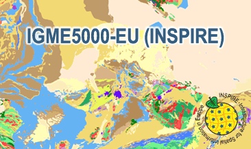
The IGME5000-EU (INSPIRE) represents the pre-quaternary bedrock geology (onshore and offshore) of the European map on a scale of 1:5,000,000. According to the Data Specification on Geology (D2.8.II.4_v3.0) the geological map provides INSPIRE-compliant data. The WMS IGME5000-EU contains layers of the geologic units (GE.GeologicUnit) and faults (GE.GeologicFault) mostly displayed according to the INSPIRE portrayal rules. The geologic units are represented graphically by stratigraphy (GE.GeologicUnit.AgeOfRocks) and lithology (GE.GeologicUnit.Lithology). For different geochronologic minimum and maximum ages, e.g. Ordovician - Silurian, the portrayal is defined by the color of the geochronologic minimum age (olderNamedAge). The portrayal of the lithology is defined by the first named rock or rock group. In case of the geologic units the user obtains detailed information via the getFeatureInfo request on the lithology and stratigraphy (age).
-
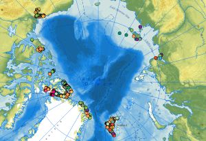
The web service of the dataset comprises the locations of outcrops with respective information on the lithology, stratigraphy, rock age and tectonic data collected during the CASE expeditions. The data attributes include stereographic projections and sketches of tectonic structures derived from the outcrop data. At the end of the 1980s, BGR initiated the research program Circum-Arctic Structural Events (CASE) to reconstruct the plate tectonic processes during the evolution of the Arctic Ocean using terrestrial data from the surrounding continental margins. One of the scientific questions of the CASE programme is as simple as it is complex: How did the Arctic Ocean, this large basin between the Eurasian and North American continental plates, develop? There are still no conclusive answers to this question in terms of plate tectonics. In contrast to the marine expeditions of geophysicists in the Arctic Ocean, geologists on land along the various coastal areas of the Arctic Ocean can directly touch, examine and map rocks, structures, folds and fault zones and determine the respective ages of the movements. This makes it possible to directly compare rock units and deformation zones on different continental plates and thus also to reconstruct when these plates collided, how long they remained next to each other and when and how they separated again. Since the inception of BGR’s Arctic research, the primary focus and research areas have been along the continental margins between Spitsbergen and the Canadian Arctic Archipelago via Greenland, to the Yukon North Slope on the border with Alaska. On the opposite side of the Arctic Ocean, there have been expeditions to Yakutia, the mainland areas near the Laptev Sea, the New Siberian Islands and to the Polar Ural with Russian partners. An important method for the interpretation of the geological evolution of the Arctic is the examination of tectonic structures (faults, folds, cleavage etc.), the determination of the kinematics and the age of the tectonic movements.
-
Storage of CO2 in deep geological formations is one possibility of reducing CO2 emissions from industry that are difficult to avoid. High-quality geological models and capacity estimates are crucial for the successful planning and implementation of safe storage projects. This study analyses the storage potential of the Middle Buntssandstein (Lower Triassic) and Lower to Middle Jurassic within the Exclusive Economic Zone (EEZ) of the German North Sea. The dataset includes maps of potential storage sites and classifications. Link https://geostor.cdrmare.de/
-
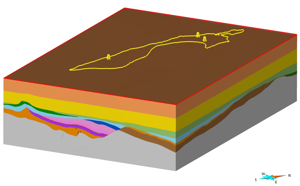
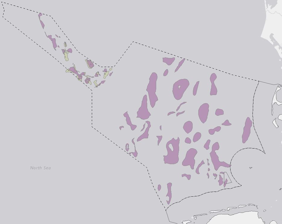
As part of the CDRmare joint project GEOSTOR (https://geostor.cdrmare.de/), the BGR created detailed static geological 3D models for two potential CO2 storage structures in the Middle Buntsandstein in the Exclusive Economic Zone (EEZ) of the German North Sea and supplemented them with petrophysical parameters (e.g. porosities, permeabilities). The 3D geological model (Pilot area B; ~560 km2) is located in the north-western part of the German North Sea sector, the so-called “Entenschnabel”, an approximately 150 kilometer long and 30 kilometer wide area between the offshore sectors of the Netherlands, Denmark and Great Britain (pilot region B). The model in the Ducks Beak is based on several high-resolution 3D seismic data and geophysical/geological information from four exploration wells. It includes 20 generalized faults and the following 16 horizon surfaces: 1) Sea Floor, 2) Mid Miocene Unconformity, 3) Base Tertiary, 4) Base Upper Cretaceous, 5) Base Lower Cretaceous, 6) Base Upper Jurassic, 7) Base Lower Jurassic, 8) Base Muschelkalk, 9) Base Röt, 10) Base Solling Formation, 11) Base Detfurth Formation, 12) Base Volpriehausen Wechselfolge, 13) Base Volpriehausen Formation, 14) Base Triassic, 15) Base Zechstein, 16) Top Basement. The reservoir formed by sandstones of the Middle Buntsandstein is located within the Mads Graben, which is bounded to the west by the extensive Mads Fault (normal fault). Marine mudstones of the Upper Jurassic and Lower Cretaceous serve as the main seal formations. Petrophysical analyses of all considered well data were conducted and reservoir properties (including porosity and permeability) were calculated to determine the static reservoir capacity for these potential CO2 storage structures. The model parameterized and can be used for further dynamic simulations of storage capacity, geo-risk, and infrastructure analyses, in order to develop a comprehensive feasibility study for potential CO2 storage within the project framework. The 3D models were created by the BGR between 2021 and 2024. SKUA-GOCAD was used as the modeling software. We would like to thank AspenTech for providing licenses for their SSE software package as part of the Academic Program (https://www.aspentech.com/en/academic-program).
-

INSPIRE theme Geology. Provision of the sediment distribution of the seabed in the North and Baltic Sea.
-
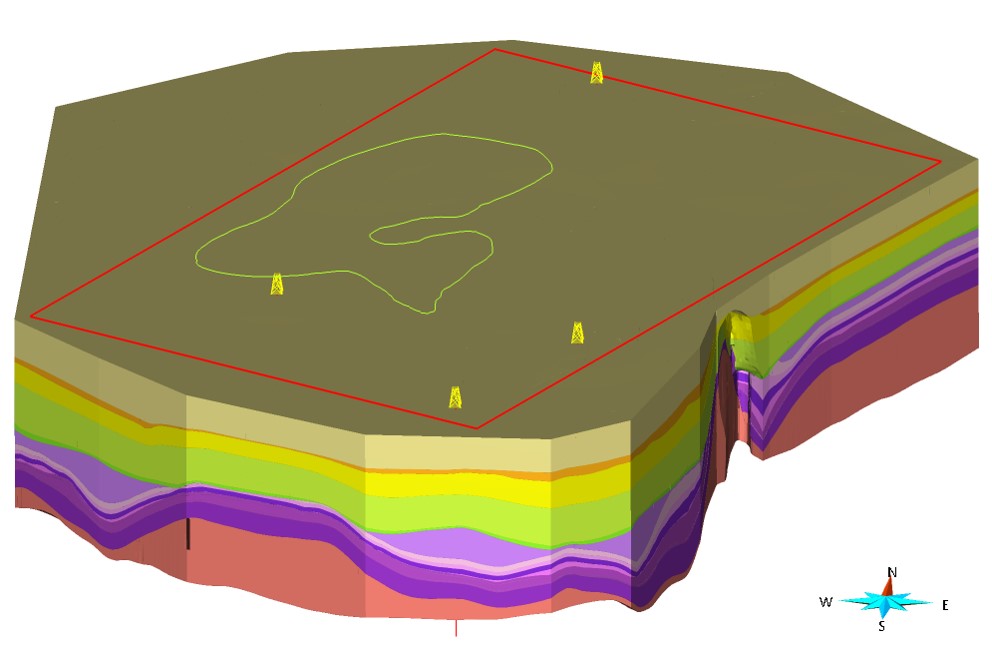
As part of the CDRmare joint project GEOSTOR (https://geostor.cdrmare.de/), the BGR created detailed static geological 3D models for two potential CO2 storage structures in the Middle Buntsandstein in the Exclusive Economic Zone (EEZ) of the German North Sea and supplemented them with petrophysical parameters (e.g. porosities, permeabilities). The 3D geological model (Pilot area A; ~1300 km2) is located on the West Schleswig Block in the area of the Henni salt pillow (pilot region A). It is based on 2D seismic data from various surveys and geophysical/geological information from four exploration wells. The model comprises 14 generalized faults and the following 14 horizon surfaces: 1) Sea Floor, 2) Mid Miocene Unconformity, 3) Base Rupelian, 4) Base Tertiary, 5) Base Upper Cretaceous, 6) Base Lower Cretaceous, 7) Base Muschelkalk, 8) Base Röt (Pelite), 9) Base Röt (Salinar), 10) Base Solling Formation, 11) Base Detfurth Formation, 12) Base Volpriehausen Formation, 13) Base Triassic, 14) Base Zechstein. The selected potential reservoir structure in the Middle Buntsandstein is formed by an anticline created by the uplift of the underlying Henni salt pillow. The primary reservoir unit is the 40-50 m thick Lower Volpriehausen Sandstone, the main sealing units are the Röt and the Lower Cretaceous. Petrophysical analyses of all considered well data were conducted and reservoir properties (including porosity and permeability) were calculated to determine the static reservoir capacity for these potential CO2 storage structures. Both models were parameterized and can be used for further dynamic simulations of storage capacity, geo-risk, and infrastructure analyses, in order to develop a comprehensive feasibility study for potential CO2 storage within the project framework. The 3D models were created by the BGR between 2021 and 2024. SKUA-GOCAD was used as the modeling software. We would like to thank AspenTech for providing licenses for their SSE software package as part of the Academic Program (https://www.aspentech.com/en/academic-program).