 My GeoNetwork catalogue
Hydrogeology
Provided by
Type of resources
Available actions
Topics
Keywords
Contact for the resource
Service types
-
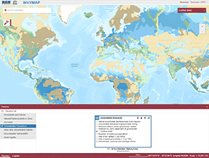
The World-wide Hydrogeological Mapping and Assessment Programme (WHYMAP) provides data and information about the earth´s major groundwater resources. The WHYMAP Viewer provides access to the topics “Groundwater Resources of the World", "World-wide River and Groundwater Basins", "World-wide Groundwater Vulnerability", "Karst Aquifers of the World", and to the “World-wide Hydrogeological Map Information System (WHYMIS)”.
-
The World-wide Hydrogeological Map Information System (WHYMIS) offers information on the availability of hydrogeological and other groundwater related maps at national (country) and international (continent) level.
-
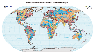
The World-wide Hydrogeological Mapping and Assessment Programme (WHYMAP) provides data and information about the earth´s major groundwater resources. The Map of Global Groundwater Vulnerability to Floods and Droughts indicates the vulnerability level of groundwater resources of the earth. It presents the intrinsic vulnerability of groundwater systems and the sensitivity or resistance of those systems to natural disasters.
-
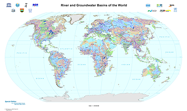
The World-wide Hydrogeological Mapping and Assessment Programme (WHYMAP) provides data and information about the earth´s major groundwater resources. The River and Groundwater Basins Map shows the areal extent of the global groundwater and surface water basins.
-
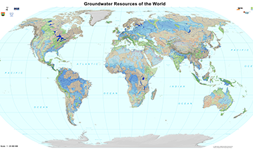
The World-wide Hydrogeological Mapping and Assessment Programme (WHYMAP) provides data and information about the earth´s major groundwater resources. The Groundwater Resources Map shows various characteristic groundwater environments in their areal extent and classified by their aquifer productivity and recharge potential. Additional groundwater related features such as wetlands and areas of low rainfall are included in the dataset.
-
Considering water as the primary resource necessary for social life, agriculture, industry, and wealth, the importance of groundwater investigation is clear. Apart from many other pollutants, this work focusses on geogenic uranium (U) and radium (Ra), which both stand for natural radionuclides (NORM) that need to be considered frame of groundwater exploration and monitoring programmes due to their specific mobility and chemo-/radiotoxicity. As investigation of U and – to a lesser extent - Ra is done by an increasing number of scientific working groups, the global dataset is improving continuously. In order to give a summarized overview on available and recent literature, scientific papers, reports, and governmental documents have been reviewed for U-238 mass concentrations and Ra-226 and Ra-228 activity concentrations and collected in tables and global maps. Further natural isotopes of U and Ra have been rarely subject of investigation. The collected data were evaluated and interpreted in frame of an associated scientific publication (see citation). From the available data it can be concluded that high geogenic U occur mainly under oxidizing conditions and carbonate rich groundwater, which might be seen as indicator for elevated U concentrations. Certain geological formations, as for example sedimentary, granitic, and volcanic host rocks, promote high U concentrations in groundwater. For geogenic Ra, the search for definite indications proved difficult, since less clear correlation is given for any observed factor. In a global perspective, the most promising evidence for elevated Ra are highly reducing redox conditions, as well as the occurrence of Fe/Mn mineral phases. Furthermore, barite represents a sink for Ra due to its ability to incorporate Ra isotopes. Dissolution of those mineral phases eventually results in co-dissolution of Ra, when Ra is found in host rocks of investigated aquifers, or downstream of such groundwater reservoirs. Furthermore, cation exchange might enhance Ra mobility process, especially in case of sedimentary aquifers with low sorption capacity and/or aquifers with high salinity. Given those chemical requirements for the occurrence of U and Ra, a negative correlation between mother and daughter nuclide can be established. When knowledge on present geological and geochemical constraints is available, elevated U and Ra concentrations might be predictable, as long as anthropogenic influence is excluded.
-
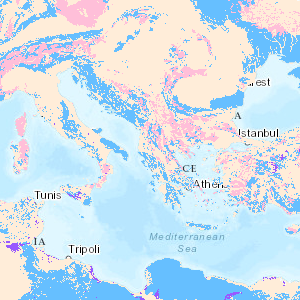
Karst aquifers constitute important freshwater resources, but are challenging to manage and to protect, because of their unique hydraulic structure and behaviour, representing continuous challenges for research and development. Karst aquifers are widespread and contribute to freshwater supply of most Mediterranean countries and many cities are supplied by karst water, e.g., Rome, Vienna, Montpellier and Beirut. These land surfaces correspond to the main recharge zones of karst aquifers, which are often hydraulically connected over large areas and are highly vulnerable to contamination. The preparation of the Mediterranean Karst Aquifer Map (MEDKAM) generally followed the workflow used for the World Karst Aquifer Map (WOKAM). A new lithological classification has been developed for the MEDKAM, similar to that of the WOKAM, which groups the geological units into four meaningful hydrogeological units: 1). Karst aquifers in sedimentary and metamorphic carbonate rocks. 2). Karst aquifers in evaporite rocks. 3). Various hydrogeological settings in other sedimentary and volcanic formations (karst aquifers are possibly present at depth). 4). Local, poor and shallow aquifers in other metamorphic rocks and igneous rocks (no karst aquifers present at depth).
-
The World-wide Hydrogeological Map Information System (WHYMIS) offers information on the availability of hydrogeological and other groundwater related maps at national (country) and international (continent) level.
-
The World-wide Hydrogeological Mapping and Assessment Programme (WHYMAP) provides data and information about the earth´s major groundwater resources. The River and Groundwater Basins Map shows the areal extent of the global groundwater and surface water basins.
-
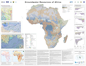
The Groundwater Resources of Africa Map represents the current state of WHYMAP’s groundwater resources mapping in Africa and was prepared for the 7th Africa Water Week 2018 in Libreville (Gabon). It includes novel features, such as cross-sections and regional transboundary hydrogeological maps, bringing together generalised overview maps and regional hydrogeological studies, thereby adding value through the inclusion of higher resolution spatial information in regions where ongoing BGR technical cooperation projects are taking place. These regional mapping activities methodologically follow the spirit of the development of the International Hydrogeological Map of Europe (IHME1500), the only harmonised, pan-European dataset at a scale of 1:1?500?000. For the IHME1500, a lithological classification scheme was developed at BGR (Duscher et al., 2015) and combined with the Standard Legend for Hydrogeological Maps (SLHyM) of Struckmeier & Margat (1995). The regional maps apply this European approach to the mapping of groundwater resources in Africa. These medium-scale maps are a further step towards regional integrated water resources planning and allow for specific analyses, such as vulnerability assessments of groundwater resources to climate change and pollution. The World-wide Hydrogeological Mapping and Assessment Programme (WHYMAP) is a joint programme consisting of a consortium composed by the UNESCO, the Commission for the Geological Map of the World (CGMW), the International Association of Hydrogeologists (IAH), the International Atomic Energy Agency (IAEA), the International Groundwater Resources Assessment Centre (IGRAC), and the German Federal Institute for Geosciences and Natural Resources (BGR). Its main objective is to contribute to the global effort to better understand, manage and protect aquifer resources, and to communicate this groundwater-related information appropriately to groundwater experts, non-experts and policy-makers.