 My GeoNetwork catalogue
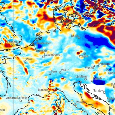
Weltweit
Provided by
Type of resources
Available actions
Topics
Keywords
Contact for the resource
Update frequencies
Service types
-
A global Earth Magnetic Anomaly Grid (EMAG2) was compiled from satellite, ship and airborne magnetic measurements. (Maus et al., 2009) Over the continents and the Arctic we made use of exisiting magnetic anomaly grids, whereas original ship and airborne trackline data were processed over the rest of the oceans, wherever available. CHAMP satellite magnetic measurements provided the magnetic field at wavelengths above 330 km. The EMAG2 grid is available at http://geomag.org and http://ngdc.noaa.gov. Directional gridding Due to the sparsity of magnetic field measurements in the southern oceans, it is necessary to interpolate the magnetic field between tracklines. Our interpolation algorithm takes the direction of the magnetic lineations into account. Tje lineations are parallel to the isochrons, which are perpendicular to the gradient of the age of teh oceanic crust. We use the age grid of Müller et al. (2008). The magnetic field ad a given grid point is computet by Least Squares Collocation from the surrounding measurements. If the point is on land, we use an isotropic correlation function with Rc = 14 km correlation length. Over the oceans we use Rc = 56 km parallel to the isochrons and Rc = 14 km in the spreading direction. Measurements seperated from the grid point by an age discontinuity or a topographic feature are excluded from the collation.
-
The World-wide Hydrogeological Map Information System (WHYMIS) offers information on the availability of hydrogeological and other groundwater related maps at national (country) and international (continent) level.
-
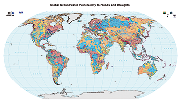
The World-wide Hydrogeological Mapping and Assessment Programme (WHYMAP) provides data and information about the earth´s major groundwater resources. The Map of Global Groundwater Vulnerability to Floods and Droughts indicates the vulnerability level of groundwater resources of the earth. It presents the intrinsic vulnerability of groundwater systems and the sensitivity or resistance of those systems to natural disasters.
-
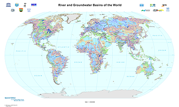
The World-wide Hydrogeological Mapping and Assessment Programme (WHYMAP) provides data and information about the earth´s major groundwater resources. The River and Groundwater Basins Map shows the areal extent of the global groundwater and surface water basins.
-
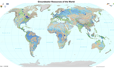
The World-wide Hydrogeological Mapping and Assessment Programme (WHYMAP) provides data and information about the earth´s major groundwater resources. The Groundwater Resources Map shows various characteristic groundwater environments in their areal extent and classified by their aquifer productivity and recharge potential. Additional groundwater related features such as wetlands and areas of low rainfall are included in the dataset.
-
The World-wide Hydrogeological Mapping and Assessment Programme (WHYMAP) provides data and information about the earth´s major groundwater resources. The Map of Global Groundwater Vulnerability to Floods and Droughts indicates the vulnerability level of groundwater resources of the earth. It presents the intrinsic vulnerability of groundwater systems and the sensitivity or resistance of those systems to natural disasters.
-
Considering water as the primary resource necessary for social life, agriculture, industry, and wealth, the importance of groundwater investigation is clear. Apart from many other pollutants, this work focusses on geogenic uranium (U) and radium (Ra), which both stand for natural radionuclides (NORM) that need to be considered frame of groundwater exploration and monitoring programmes due to their specific mobility and chemo-/radiotoxicity. As investigation of U and – to a lesser extent - Ra is done by an increasing number of scientific working groups, the global dataset is improving continuously. In order to give a summarized overview on available and recent literature, scientific papers, reports, and governmental documents have been reviewed for U-238 mass concentrations and Ra-226 and Ra-228 activity concentrations and collected in tables and global maps. Further natural isotopes of U and Ra have been rarely subject of investigation. The collected data were evaluated and interpreted in frame of an associated scientific publication (see citation). From the available data it can be concluded that high geogenic U occur mainly under oxidizing conditions and carbonate rich groundwater, which might be seen as indicator for elevated U concentrations. Certain geological formations, as for example sedimentary, granitic, and volcanic host rocks, promote high U concentrations in groundwater. For geogenic Ra, the search for definite indications proved difficult, since less clear correlation is given for any observed factor. In a global perspective, the most promising evidence for elevated Ra are highly reducing redox conditions, as well as the occurrence of Fe/Mn mineral phases. Furthermore, barite represents a sink for Ra due to its ability to incorporate Ra isotopes. Dissolution of those mineral phases eventually results in co-dissolution of Ra, when Ra is found in host rocks of investigated aquifers, or downstream of such groundwater reservoirs. Furthermore, cation exchange might enhance Ra mobility process, especially in case of sedimentary aquifers with low sorption capacity and/or aquifers with high salinity. Given those chemical requirements for the occurrence of U and Ra, a negative correlation between mother and daughter nuclide can be established. When knowledge on present geological and geochemical constraints is available, elevated U and Ra concentrations might be predictable, as long as anthropogenic influence is excluded.
-
The World-wide Hydrogeological Mapping and Assessment Programme (WHYMAP) provides data and information about the earth´s major groundwater resources. The Groundwater Resources Map shows various characteristic groundwater environments in their areal extent and classified by their aquifer productivity and recharge potential. Additional groundwater related features such as wetlands and areas of low rainfall are included in the dataset.
-
Considering water as the primary resource necessary for social life, agriculture, industry, and wealth, the importance of groundwater investigation is clear. Apart from many other pollutants, this work focusses on geogenic uranium (U) and radium (Ra), which both stand for natural radionuclides (NORM) that need to be considered frame of groundwater exploration and monitoring programmes due to their specific mobility and chemo-/radiotoxicity. As investigation of U and – to a lesser extent - Ra is done by an increasing number of scientific working groups, the global dataset is improving continuously. In order to give a summarized overview on available and recent literature, scientific papers, reports, and governmental documents have been reviewed for U-238 mass concentrations and Ra-226 and Ra-228 activity concentrations and collected in tables and global maps. Further natural isotopes of U and Ra have been rarely subject of investigation. The collected data were evaluated and interpreted in frame of an associated scientific publication (see citation). From the available data it can be concluded that high geogenic U occur mainly under oxidizing conditions and carbonate rich groundwater, which might be seen as indicator for elevated U concentrations. Certain geological formations, as for example sedimentary, granitic, and volcanic host rocks, promote high U concentrations in groundwater. For geogenic Ra, the search for definite indications proved difficult, since less clear correlation is given for any observed factor. In a global perspective, the most promising evidence for elevated Ra are highly reducing redox conditions, as well as the occurrence of Fe/Mn mineral phases. Furthermore, barite represents a sink for Ra due to its ability to incorporate Ra isotopes. Dissolution of those mineral phases eventually results in co-dissolution of Ra, when Ra is found in host rocks of investigated aquifers, or downstream of such groundwater reservoirs. Furthermore, cation exchange might enhance Ra mobility process, especially in case of sedimentary aquifers with low sorption capacity and/or aquifers with high salinity. Given those chemical requirements for the occurrence of U and Ra, a negative correlation between mother and daughter nuclide can be established. When knowledge on present geological and geochemical constraints is available, elevated U and Ra concentrations might be predictable, as long as anthropogenic influence is excluded.
-

The online map displays the location, surface extension and environmental hazard potentials for 100 mine sites for iron, copper and bauxite. The map contains standard map tools, filter functions and info boxes providing back-ground information on the OekoRess III project and the applied evaluation method. When the user clicks on each mine site displayed, a drop-down list appears that contains further site-specific information and a link for down-loading a factsheet (pdf).