 My GeoNetwork catalogue
monthly
Provided by
Type of resources
Available actions
Topics
Keywords
Contact for the resource
Update frequencies
-
Global maps of monthly mean surface air pressure derived from GME model data , WMO RA VI Regional Climate Centre (RCC) on Climate Monitoring
-
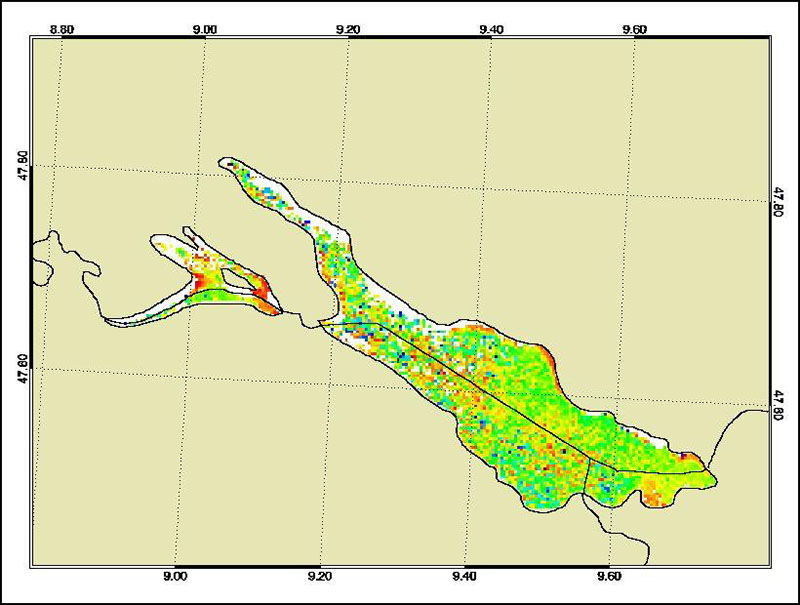
The Medium Resolution Imaging Spectrometer (MERIS) on Board ESA’s ENVISAT provides spectral high resolution image data in the visible-near infrared spectral region (412-900 nm) at a spatial resolution of 300 m. For more details on ENVISAT and MERIS see http://envisat.esa.int/ This product developed in the frame of the MAPP project (MERIS Application and Regional Products Projects) represents the chlorophyll concentration of Lake Constance derived from MERIS data. The product is a cooperative effort of DLR-DFD and the Institute for Coastal Research at the GKSS Research Centre Geesthacht. DFD pre-processed up to the value added level whenever MERIS data for the North Sea region was received and positively checked for a water area large enough for a suitable interpretation. For more details the reader is referred to http://wdc.dlr.de/sensors/meris/ and http://wdc.dlr.de/sensors/meris/documents/Mapp_ATBD_final_i3r0dez2001.pdf This product provides monthly maps.
-
Global maps of monthly normals 1961-1990 of surface air pressure derived from GME model data, provided by WMO RA VI Regional Climate Centre (RCC) on Climate Monitoring
-
Global maps of anomalies of monthly mean surface air pressure derived from GME model data (reference period 1961-1990), WMO RA VI Regional Climate Centre (RCC) on Climate Monitoring
-
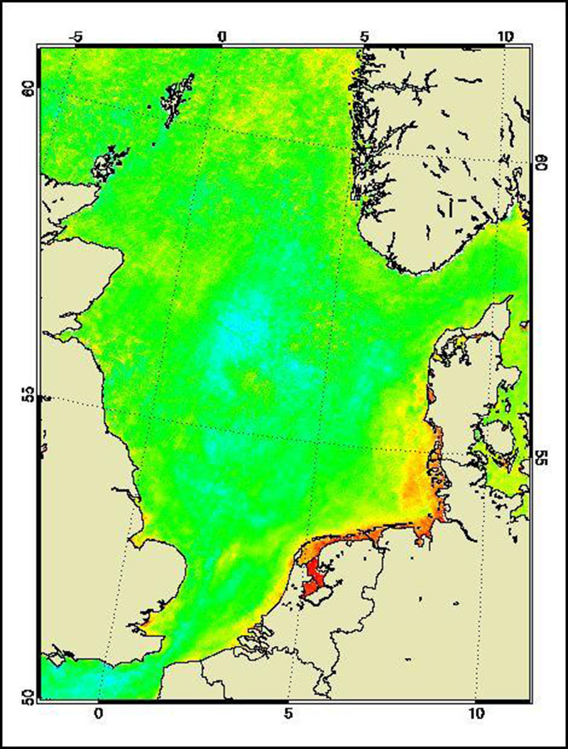
The Medium Resolution Imaging Spectrometer (MERIS) on Board ESA’s ENVISAT provides spectral high resolution image data in the visible-near infrared spectral region (412-900 nm) at a spatial resolution of 300 m. For more details on ENVISAT and MERIS see http://envisat.esa.int/ This product developed in the frame of the MAPP project (MERIS Application and Regional Products Projects) represents the chlorophyll concentration of the North Sea derived from MERIS data. The product is a cooperative effort of DLR-DFD and the Institute for Coastal Research at the GKSS Research Centre Geesthacht. DFD pre-processed up to the value added level whenever MERIS data for the North Sea region was received and positively checked for a water area large enough for a suitable interpretation. For more details the reader is referred to http://wdc.dlr.de/sensors/meris/ and http://wdc.dlr.de/sensors/meris/documents/Mapp_ATBD_final_i3r0dez2001.pdf This product provides monthly maps.
-
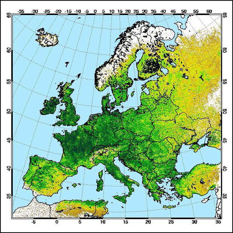
The "AVHRR compatible Normalized Difference Vegetation Index derived from MERIS data (MERIS_AVHRR_NDVI)" was developed in a co-operative effort of DLR (German Remote Sensing Data Centre, DFD) and Brockmann Consult GmbH (BC) in the frame of the MAPP project (MERIS Application and Regional Products Projects). For the generation of regional specific value added MERIS level-3 products, MERIS full-resolution (FR) data are processed on a regular (daily) basis using ESA standard level-1b and level-2 data as input. The regular reception of MERIS-FR data is realized at DFD ground station in Neustrelitz. The Medium Resolution Imaging MERIS on Board ESA's ENVISAT provides spectral high resolution image data in the visible-near infrared spectral region (412-900 nm) at a spatial resolution of 300 m. For more details on ENVISAT and MERIS see http://envisat.esa.int The Advanced Very High Resolution Radiometer (AVHRR) compatible vegetation index (MERIS_AVHRR_NDVI) derived from data of the MEdium Resolution Imaging Spectrometer (MERIS) is regarded as a continuity index with 300 meter resolution for the well-known Normalized Difference Vegetation Index (NDVI) derived from AVHRR (given in 1km spatial resolution). The NDVI is an important factor describing the biological status of canopies. This product is thus used by scientists for deriving plant and canopy parameters. Consultants use time series of the NDVI for advising farmers with best practice. For more details the reader is referred to http://wdc.dlr.de/sensors/meris/ and http://wdc.dlr.de/sensors/meris/documents/Mapp_ATBD_final_i3r0dez2001.pdf This product provides monthly maps.
-

The Medium Resolution Imaging Spectrometer (MERIS) on Board ESA’s ENVISAT provides spectral high resolution image data in the visible-near infrared spectral region (412-900 nm) at a spatial resolution of 300 m. For more details on ENVISAT and MERIS see http://envisat.esa.int/ Spectral high resolution measurements allow to assess different water constituents in optically complex case-2 waters (IOCCG, 2000). The main groups of constituents are Chlorophyll, corresponding to living phytoplankton, suspended minerals or sediments and dissolved organic matter. They are characterised by their specific inherent optical properties, in particular scattering and absorption spectra. The Baltic Sea Water Constituents product was developed in a co-operative effort of DLR (Remote Sensing Technology Institute IMF, German Remote Sensing Data Centre DFD), Brockmann Consult (BC) and Baltic Sea Research Institute (IOW) in the frame of the MAPP project (MERIS Application and Regional Products Projects). The data are processed on a regular (daily) basis using ESA standard Level-1 and -2 data as input and producing regional specific value added Level-3 products. The regular data reception is realised at DFD ground station in Neustrelitz. For more details the reader is referred to http://wdc.dlr.de/sensors/meris/ and http://wdc.dlr.de/sensors/meris/documents/Mapp_ATBD_final_i3r0dez2001.pdf This product provides monthly maps.
-
Grids of monthly DWD drought index derived from GPCC data on a 1x1 degree grid, provided by WMO RA VI Regional Climate Centre (RCC) on Climate Monitoring
-
Maps of monthly DWD drought index derived from GPCC data on a 1x1 degree grid, provided by WMO RA VI Regional Climate Centre (RCC) on Climate Monitoring
-
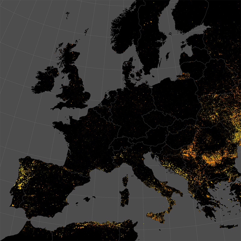
This data set represents the monthly, accumulated results of the final (10-day) version of the fire perimeters from the "Burnt Area Daily NRT Incremental Product - Europe, Sentinel-3" dataset. The burn perimeters are spatially and temporally correlated, so that interrelated detections from consecutive observations are combined into a single feature. A perimeter is interpreted as belonging to a given event if a spatial overlap exists within a time frame of 15 days. Besides the geometry, attribute information is also combined while considering the size of the perimeter as a weighting factor. Each feature contains information about the final fire perimeter, Date/Time of the first detection, and the averaged burn severity.