 My GeoNetwork catalogue
Stratigraphy
Provided by
Type of resources
Available actions
Topics
Keywords
Contact for the resource
Service types
-
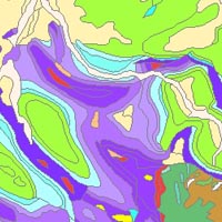
The “Geological Map of Germany 1:1,000,000 OneGeology-Europe (GK1000-1GE)” shows Germany’s surface geology: All geological units are described by their age (stratigraphy) and composition (lithology). The geological units and terms used in this map were semantically harmonized within the OneGeology-Europe project and have been - in a number of regions - geometrically and semantically made consistent with the neighbouring OneGeology-Europe participants.
-
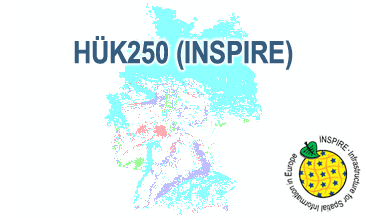
The HÜK250 (INSPIRE) describes the hydrogeological characteristics of the upper continuous aquifers in Germany at a scale of 1:250,000. According to the Data Specification on Geology (D2.8.II.4_v3.0) the map provides INSPIRE-compliant data. The hydrogeologic units are represented graphically – mostly according to the INSPIRE portrayal rules – by GE.Aquifer.MediaType, GE.Aquifer.HydrogeochemicalRockType, GE.Aquifer.permeabilityCoefficient (BGR colours), GE.Aquitard.approximatePermeabilityCoefficient (BGR colours), GE.Aquitard and GE.Aquiclude.ConstitutionOfAquiclude. The geologic units are represented graphically – according to the INSPIRE portrayal rules – by GE.GeologicUnit.AgeOfRocks and GE.GeologicUnit.Lithology. The HÜK250 is a joint project of the SGD under the leadership of the BGR.
-
The HÜK250 (INSPIRE) describes the hydrogeological characteristics of the upper continuous aquifers in Germany at a scale of 1:250,000. According to the Data Specification on Geology (D2.8.II.4_v3.0) the content of the map is stored in a INSPIRE-compliant GML file: HUEK250.gml. The GML file together with a Readme.txt file is provided in ZIP format. The Readme.txt file (German/English) contains detailed information on the GML file content. Data transformation was proceeded by using the INSPIRE Solution Pack for FME according to the INSPIRE requirements.
-
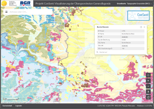
The ConSent Viewer shows the lithostratigraphic units of Bavaria and Baden-Wurttemberg of the superior lithostratigraphic general legend as well as their original data in the scale 1:25.000 resp. 1:50.000. The attributes of the superior legend contain the names, symbols and URIs of the lithostratigraphic units of Bavaria and Baden-Wurttemberg as well as their linkage by means of the SKOS vocabulary. At first, the application shows in small scales the map GK2000 for whole Germany. By zooming in, the maps GK1000 and GÜK250 appear in sequence until the map data of Bavaria and Baden-Wurttemberg are displayed.