 www.geodatenkatalog.de (S1L)
Keyword
Lithology
19 record(s)
Provided by
Type of resources
Available actions
Topics
Keywords
Contact for the resource
Update frequencies
Service types
-
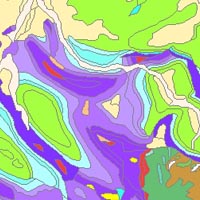
The “Geological Map of Germany 1:1,000,000 OneGeology-Europe (GK1000-1GE)” shows Germany’s surface geology: All geological units are described by their age (stratigraphy) and composition (lithology). The geological units and terms used in this map were semantically harmonized within the OneGeology-Europe project and have been - in a number of regions - geometrically and semantically made consistent with the neighbouring OneGeology-Europe participants.
-
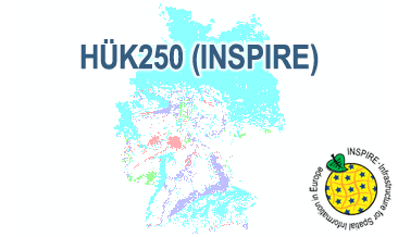
The HÜK250 (INSPIRE) describes the hydrogeological characteristics of the upper continuous aquifers in Germany at a scale of 1:250,000. According to the Data Specification on Geology (D2.8.II.4_v3.0) the map provides INSPIRE-compliant data. The hydrogeologic units are represented graphically – mostly according to the INSPIRE portrayal rules – by GE.Aquifer.MediaType, GE.Aquifer.HydrogeochemicalRockType, GE.Aquifer.permeabilityCoefficient (BGR colours), GE.Aquitard.approximatePermeabilityCoefficient (BGR colours), GE.Aquitard and GE.Aquiclude.ConstitutionOfAquiclude. The geologic units are represented graphically – according to the INSPIRE portrayal rules – by GE.GeologicUnit.AgeOfRocks and GE.GeologicUnit.Lithology. The HÜK250 is a joint project of the SGD under the leadership of the BGR.
-
The HÜK250 (INSPIRE) describes the hydrogeological characteristics of the upper continuous aquifers in Germany at a scale of 1:250,000. According to the Data Specification on Geology (D2.8.II.4_v3.0) the content of the map is stored in a INSPIRE-compliant GML file: HUEK250.gml. The GML file together with a Readme.txt file is provided in ZIP format. The Readme.txt file (German/English) contains detailed information on the GML file content. Data transformation was proceeded by using the INSPIRE Solution Pack for FME according to the INSPIRE requirements.
-
Dieser Dienst stellt für das INSPIRE-Thema Geologie aus der geologischen Karte im Maßstab 1:25000 umgesetzte Daten, des Landesamt für Umwelt- und Arbeitsschutz bereit.:Dieser Layer visualisiert die räumlichen MappedFeature-Objekte der saarländischen Geologischen Daten (GK25), deren Spezifikationseigenschaft vom Typ GeologicUnit ist. Die Datengrundlage erfüllt die INSPIRE Datenspezifikation.
-
INSPIRE Geologie in Mecklenburg-Vorpommern
-
Dieser Dienst stellt für das INSPIRE-Thema Geologie aus der geologischen Karte im Maßstab 1:100000 umgesetzte Daten, des Landesamt für Umwelt- und Arbeitsschutz bereit.:Dieser Layer visualisiert die räumlichen MappedFeature-Objekte der saarländischen Geologischen Daten (GK100), deren Spezifikationseigenschaft vom Typ GeologicUnit ist. Die Datengrundlage erfüllt die INSPIRE Datenspezifikation.
-
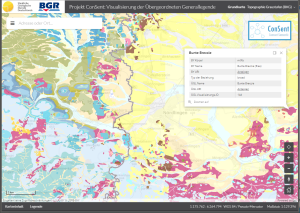
The ConSent Viewer shows the lithostratigraphic units of Bavaria and Baden-Wurttemberg of the superior lithostratigraphic general legend as well as their original data in the scale 1:25.000 resp. 1:50.000. The attributes of the superior legend contain the names, symbols and URIs of the lithostratigraphic units of Bavaria and Baden-Wurttemberg as well as their linkage by means of the SKOS vocabulary. At first, the application shows in small scales the map GK2000 for whole Germany. By zooming in, the maps GK1000 and GÜK250 appear in sequence until the map data of Bavaria and Baden-Wurttemberg are displayed.
-
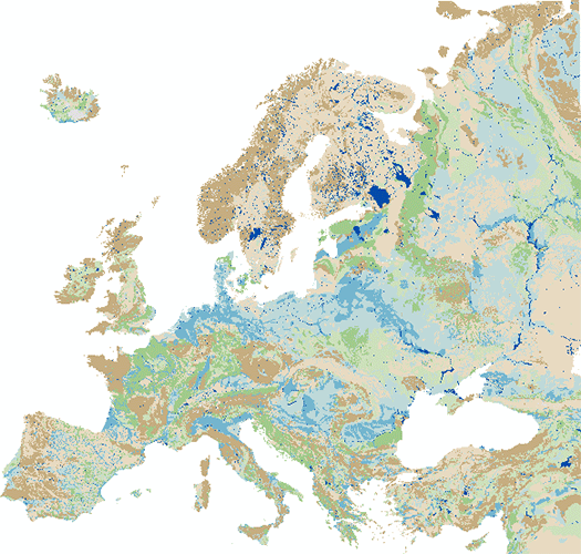
The IHME1500 v1.2 is a vector dataset resulting from the digitisation of the 25 published map sheets of the International Hydrogeological Map of Europe at the of scale 1:1,500,000 (IHME1500). The dataset was extended for five unpublished, digitised IHME1500 map sheets to achieve full map coverage. It consists of selected features of the IHME1500 with the following content: - Aquifer types (area): Distinction of six types of aquifers according to their productivity and void types. - Lithology (area): Lithological classification of the aquifers at five aggregation levels. - Seawater intrusion (area): Areas with salination of groundwater caused by sea water intrusion. - Tectonic fractures (line): Geological lineaments assigned to the five classes of known or supposed faults or overthrusts and boundaries of fractured belts in Iceland. The IHME1500 v1.2 includes a correction of inconsistencies of the printed map sheets and was spatially adjusted to an up-to-date topographic base. The IHME1500 is a hydrogeological map series consisting of 25 published map sheets with explanatory notes that covers the European continent and parts of the Near East. The Federal Institute for Geosciences and Natural Resources (BGR) and the United Nations Educational, Scientific and Cultural Organization (UNESCO) are the project coordinators, supported by the International Association of Hydrogeologists (IAH) and the Commission for the Geological Map of the World (CGMW). Each sheet consists of contributions by the respective countries represented in the map, which were harmonised across borders. The map series including the explanatory notes can be used for scientific purposes, for large-scale regional planning and as a framework for detailed hydrogeological mapping.
-
Die geologischen Einheiten beschreiben die oberflächennahe Geologie in Berlin mit Attributen des INSPIRE-Datenmodells "Geologie".