 My GeoNetwork catalogue
Federal Institute for Geosciences and Natural Resources
Provided by
Type of resources
Available actions
Topics
Keywords
Contact for the resource
Service types
-
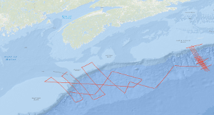
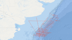
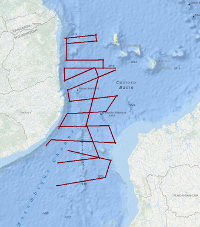
In the frame of the Continental Margin Study Program of the Federal Institute for Geosciences and Natural Resources (BGR, Hannover) marine geophysical measurements (48-channel reflection seismic, sono-buoy refraction, gravity and magnetic) were conducted over the Atlantic continental margin of Canada from 23th July to 7th August 1979 with S.V. EXPLORA (BGR79 leg 2). The survey on the Canadian continental margin was planned in cooperation between the Federal Institute for Geosciences and Natural Resources (BGR) and the Atlantic Geoscience Centre of the Geological Survey of Canada (Bedford Institute of Oceanography, Dartmonth, N.S.) on the base of existing Canadian multichannel seismic lines. A main target of the cruise was to acquire data which allow a comparison of the deep sedimentary basins offshore Nova Scotia with the already known basins offshore Morocco. The eastern part of the survey imaged complex structural deformation due to salt diapirs. The western seismic lines allowed to investigate the structural relationship between the Scotian Basin and the Georges Bank.
-
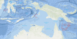
The results of the 1978 SONNE survey by the Federal Institute for Geosciences and Natural Resources (BGR), in the Coral Sea indicated the presence of narrow rift valleys beneath the outer margins of the Queensland and Papuan Plateaus. On the margins of these valleys, features were observed which were then interpreted to be large fossil reefs underlying an Eocene/Oligocene unconformity. These conclusions were important because they indicated that the Coral Sea Basin region is ideal for research into the fundamental problems concerning the development of continental margins. That is, the region offers similar problems to areas of the world where detailed studies are currently being conducted (e.g. West African margin) but with less complicated superimposed structure and a much thinner sediment cover. During the period from 29th November 1980 to 9th January 1981 a 'follow up' survey on the first and second leg of cruise SO-16 using the R/V SONNE was carried out in the northern Coral Sea, around the margins of the Coral Sea Basin, by the BGR in co-operation with the Bureau of Mineral Resources, Geology and Geophysics, Canberra (BMR) and the Geological Survey of Papua New Guinea, Port Moresby (GSPNG). The survey, which was divided into a geophysical cruise (first leg of SO-16) and a geological sampling cruise (second leg of SO-16), resulted in the recording of about 7,140 km of bathymetric and gravimetric data, of about 6,950 km of magnetic data, 3,150 km of digital multichannel seismic reflection profiles, 3,560 km of analogue single channel seismic reflection profiles, 10 sonobuoy refraction profiles and the sampling of 16 stations by dredging and 9 by coring. In the period from 9th January to 6th February 1981, geophysical investigations on the 3rd leg of SONNE cruise SO-16 were carried out in the Arafura Sea between Tanimbar, Aru and Kai Islands, and in the southern part of the Makassar Strait by BGR in co-operation with the Geological Research and Development Centre, Dept. Mines and Energy of Indonesia, Bandung and the Indonesian lnstitute of Sciences (LIPI), Bandung. 4,060 km of bathymetric and gravity lines, 3,080 km of magnetic lines, 1,415 km of reflection seismic lines (digital and analogue), and 9 sonobuoy profiles were recorded during this leg. Objectives of the Arafura Sea survey were determination of (a) thickness, seismic pattern, tectonic style and subsidence of the Cenozoic/Mesozoic depositional sequences at the transition from the Australian continental shelf to the Tanimbar outer arc ridge and (b) the configuration of the Precambrian rocks of the above mentioned transition zone. Objectives of the Makassar Strait survey were determination of (a) the nature and configuration of the acoustic basement underlying the South Makassar Basin, (b) the formation and nature of the sediments overlying the acoustic basement, (c) the regional distribution of a major unconformity of assumed Middle Miocene age as observed on profile VA16-24 of the VALDIVIA cruise VA-16 in 1977 in order to get a better understanding of the development of the South Makassar Basin.
-
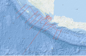
During RV SONNE cruise 137 from 21st November to 28th December 1998 Geoscientific Investigations on the active Convergence Zone between the east Eurasian and Indo-Australian Plate (GINCO I) were carried out along the Sunda Arc, off Sumatra, Java and the Sunda Strait. The studies were headed by the BGR in close cooperation with German and Indonesian research institutions. A total amount of 5,500 km of magnetic, gravity and swath bathymetric profiles were recorded of which multi-channel seismic data exceeded 4,100 km. The scientific objectives were: (1) investigation of the structure and age of the accretionary wedges, outer arc highs and fore-arc basins off Sumatra and Java with special emphasis on the evolution of the Sunda Strait and the Krakatau area (2) differences in tectonic deformation between oblique (Sumatra) versus frontal (Java) subduction (3) search for oceanic crustal splinters in the accretionary wedges (4) definition of seismic sequences, thicknesses and ages of the fore-arc basin sediments as a pre-requisite for later on hydrocarbon assessments (5) identification and regional occurrence of bottom simulating reflectors (BSR) indicating gas hydrates. From the GINCO I project there is evidence for the existence of two accretionary wedges along the Sunda Arc: wedge I is of assumed Paleogene age and wedge II of Neogene to Recent age. The first inner wedge I is composed of tectonic flakes which are correlated from SE Sumatra across the southern Sunda Strait to NW Java. This implies a very similar plate tectonic regime at the time of the flake development during the Upper Oligocene to Lower Miocene and without marked differences in plate convergence direction from Java to Sumatra. Wedge I shows backthrusting along the northern transition toward the fore-arc basin. Today, wedge I forms the outer arc high and the backstop for the younger, outer wedge II. Magnetic, gravity and seismic results show, that within both wedges, there are no indications for an oceanic crustal splinter as hitherto postulated. Both wedges are underlain by oceanic crust of the subducting Indo-Australian slab which could be correlated from the trench off Sumatra up to 135 km to the northeast and up to 65 km from the trench off Java. Since the top of the oceanic crust differs considerably in reflectivity and surface relief we distinguished two types in the seismic records. One type is characterized by strong top reflections and a smooth surface and underlies accretionary wedge II and the southwest part of the wedge I (outer arc high) off Sumatra and Java. The second type has a low reflectivity and a rougher relief and underlies the tectonic flakes of accretionary wedge I (outer arc high) between the southwestern tip of Sumatra, the SundaStrait and NW Java. The missing outer arc high off the southern entrance of the Sunda Strait is explained by Neogene transtension in combination with arc-parallel strike-slip movements. The NW-SE running, transpressional Mentawai strike-slip fault zone (MFZ) was correlated from the SE Sumatra fore-arc basin to the NW Java fore-arc basin. Off the Sunda Strait northward bending branches of the MFZ are connected with the Sumatra Fault zone (SFZ). It is speculated that the SFZ originally was attached to the Cimandiri-Pelabuhan-Ratu strike-slip faults and shifted from the volcanic arc position into the fore-arc basin area due to clockwise rotation of Sumatra with respect to Java as well as due to increasingly oblique plate convergence since the late Lower Miocene. We explain the transtension of the western Sunda Strait (Semangka graben) and the transpression with inversion of the eastern Sunda Strait, along the newly detected Krakatau Basin, by this rotation. Seismostratigraphic interpretation revealed 5 main sequences (A - E), tentatively dated as Paleogene to Recent in age. The oldest seismic sequence A of assumed Eocene to Oligocene age is bounded at the top by a major erosional unconformity that was identified on all GINCO seismic profiles. The seaward diverging seismic pattern of sequence A is interpreted as a correlative sequence to the prograding Paleogene deltaic sediments encountered by wells offshore central and northern Sumatra. This is opposed to previous interpretation which assumed seaward dipping reflector sequences of basaltic origin erupted along the former Mesozoic passive margin of Sumatra. According to constructed time structure maps, the main NW-SE running depocentres of the post-Paleogene sediments are arc-parallel off Sumatra and Java with thicknesses of 3 s (TWT) and 5 s (TWT), respectively. The main depocentres of the Semangka graben and of the Krakatau Basin of the Sunda Strait strike north-south and have infills of 2 s - 5 s (TWT). Bottom simulating reflectors (BSR) occur within the upper sequences C - D along the flanks of the fore-arc basins and along doming structures but could not be detected in basin centres. Empiric relations of heat flow values and depths of BSR were determined indicating that with increasing waterdepth and decreasing heat flow the depths of the BSR increase.
-
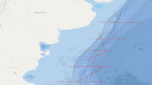
In the period from 22nd December, 1987 to 15th January, 1988 a geophysical reconnaissance survey has been carried out with S.V. EXPLORA on the Argentine Eastern continental margin. A total of 3,675 km of digital seismic reflection profiles in parallel with gravimetric and in part magnetic measurements, and 13 sonobuoy refraction profiles were recorded during this survey. The general aim of the survey was to search the Argentine eastern continental margin between 37°S and 47°S for evidence of continent-ocean boundary structures previously recognized by us off South Africa. The following preliminary results were obtained: (1) Five regional seismic markers/unconformities have been observed, named from bottom to top AR V to AR I. (2) Two units are recognizable on all reflection seismic records: A buried lower unit the top of which is marked by the distinct 'AR IV' unconformity of presumably Beriasian/Valangian age, and a tectonically undisturbed upper sedimentary unit. (3) The dominant feature of the lower unit is a 50 km to 100 km broad wedge-shaped body characterized by an internally divergent pattern of reflection horizons having seaward dip. The seismic characteristics and recent ODP drilling is consistent with the wedge being formed from extrusive basaltic rocks. (4) The more than 5000 m thick wedge is parallel with the shelf edge and can be traced continuously for 1200 km. Its landward pinchout coincides with the magnetic slope anomaly 'G'. (5) A giant contourite mound of Neogene age has been recognized in the southeastern part of the survey area. (6) Bottom simulating reflectors have been recognized. Their occurrence is associated with the contourite mound.
-
From 24th November 1998 to 24th February 1999 BGR in cooperation with YPF (Yacimientos Petrolíferos Fiscales) and SHN (Servicio de Hidrografía Naval) conducted three seismic surveys along the passive continental margin of Argentine. The seismic vessel M/V Akademik Lazarev which is operated by SMNG (Sevmorneftegeofizika) was used for these cruises. Although the seafloor spreading history of the South Atlantic Ocean is very well defined, the development of the continental margins poses still great problems to a profound understanding. When break-up of Gondwana started in Middle Jurassic, South Africa and South America remained connected. Their break-up started in Early Cretaceous, possibly propagating from south to north. Before break-up, huge tholeiitic flood basalts were extruded near the future rift, namely the Paraná basalts in Brazil and the Etendeka basalts in Namibia. It is likely that these basalts are caused by a large mantle plume. As the flood basalts were predecessors to the break-up, often a causal relationship is assumed. The dipping reflector sequences along large parts of the continental margins of South America and South Africa are interpreted as indications of the plume influence. Investigations along many passive margins have meanwhile shown that dipping reflector sequences exist along most of them. These so-called volcanic margins are the normal ones, the non-volcanic margins are the exception. For many years, it had been assumed that the hydrocarbon potential of volcanic margins is very low. The discovery of the Kudu gas field has demonstrated that this assumption is not valid in general. This increases our interest in continuing the investigation of volcanic passive margins and the variability of their structure along strike. BGR has carried out already two marine geophysical cruises off Argentina, namely with M/V EXPLORA in 1985 and with FS SONNE in 1993. These surveys had shown locally the existence of threefold dipping reflector sequences (Hinz et al., 1999). Furthermore, it had turned out that not everywhere they are accompanied by the strong magnetic G anomaly (Rabinowitz & LaBrecque, 1979). The main objectives of the BGR98 cruise were: (1) Investigation and mapping of the zone of the seaward dipping reflectors (SDR) (reflection + refraction seismic) (2) Investigation of the sedimentary column within this zone (reflection seismic) (3) Setting up a seismostratigraphy based on the seismic records obtained during the cruise and the information from the previous cruises (BGR87, SO85) as well as on additional well information (4) Comparison of the argentine seismic data with seismic data of the conjugate volcanic margin off Namibia (BGR 87). The study area is located offshore Argentine, extending from about 37° 20' S to 45° 40' S and from about 61° 10' W to 52° 00' W. It comprises the Colorado Basin as well as the outermost shelf, slope and rise of the continental margin with water depths up to 5000 m.
-
The cruise AL278 started on May, 10th 2006 in Kiel and ended in Kiel on May, 19th 2006. The previous BGR-cruises with RV AURELIA in 2003 and 2004 were designed to collect a grid of seismic MCS-data which should enable us to get a high-resolution overview over the upper 1 s TWT of the sediments of the German North Sea sector. During October/November 2005 a subsequent cruises with RV HEINCKE and FK SENCKENBERG was designed to tackle several special aims: - The detailed mapping of glacio-tectonic features North of Heligoland. - The shallow seismic mapping of the Holocene/Pleistocene-Boundary and topography of the Pleistocene sub-glacial valley system offshore of the East Friesian Islands. - High-resolution surveying of two areas designated for offshore wind farms in the southwestern German sector. - Detailed mapping of a wide and deep sub-glacial valley. One additional aim was to acquire a dense grid of seismic line in the area North of Weisse Bank where on several from previous cruises indications for shallow gas accumulations (e.g. “bright spots”) were found. Unfortunately, due to very bad weather conditions this aim could not be reached. Therefore this short cruise with RV ALKOR was used to acquire twelve MCS lines over this area. During the cruise a total ca. 1400 km of high quality MCS lines were surveyed and simultaneously measured by a sediment echosounder system that enabled additional profiles during transits with speeds 5 kn. Together with the previously acquired data these new data should help to extend our knowledge of the Late Tertiary and Quaternary evolution of the German North Sea Sector. The BGR high-resolution multichannel seismic reflection system consisting of a GI-Gun (0.8 l) and a 300 m streamer with 24 channels and a sediment echosounder type SES 2000 standard by Innomar, Rostock. While the BGR-seismic system was used to observe the shallow subsurface down to 2 s TWT penetration depth, the sediment echosounder with a penetration depth of several meters was primarily intended to identify sampling positions for the deployment of the BGR vibration corer during the succeeding Leg 2. Additionally, the echosounder system enables the relationship to the highest-resolution multichannel seismic measurements of the group of the University of Bremen on FK SENCKENBERG. All seismic records were processed onboard for the quality control and for a first interpretation.
-
SONNE cruise SO-85 was designed to study the variability of the oceanic crustal structure along flow-line profiles over Early Tertiary through Early Cretaceous old crust in the Cape and Argentine basins of the South Atlantic. Between 21th February and 20th April 1993 deep imaging seismic reflection data in parallel with magnetic, gravimetric and hydroacoustic measurements have been collected along a 1,405 km long flow-line traverse across the Cape basin, and along three flow-line traverses across the Argentine basin with a total length of 4,255 km. A special geophysical survey was carried out on the Argentine continental margin. Although bad weather hampered the geophysical measurements in the Argentine basin, some new and intriguing observations were made: (1) the presence of an elongated wedge of seaward dipping reflectors, often associated with the distinct magnetic anomaly 'G', was confirmed on both, the South African and Argentine continental margins; (2) the sequence of seaward-dipping reflectors consists of two wedges. The younger wedge rests partly on the older one; (3) the surface of the oceanic crust lies more deep in the Argentine basin than in the Cape basin; (4) the structure of the oceanic crust is more variable in time and space within the Argentine and Cape basins than within the Angola and Brazil basins; (5) despite this, it appears that the oceanic crust generated during the younger half of the Cretaceous magnetic quiet period up to C 33r is characterized by relative high reflectivity in lower crustal levels; (6) high-amplitude magnetic anomalies C 33 through C 34 are apparently correlatable with oceanic crustal segments characterized by common seismic features, e.g. a smooth and scarped surface of the oceanic crust; (7) an elongated, positive gravity anomaly exists at about 58°E between 43.5°E and 47°E.
-
The PANORAMA-2 research cruise was carried out between August 15th and September 20th 2015 aboard the Italian research vessel OGS Explora, like the PANORAMA-1 cruise in 2013. The intended survey area was the European sector of the Arctic east and southeast of the Svalbard archipelago in the area of the northern Barents Sea. Main target of the PANORAMA-2 cruise was the acquisition of new geophysical data and the probing of surficial sediments in the underexplored area of the Sørkapp Basin and Olga Basin. In the course of the 20 day lasting Leg1 of the PANORAMA-2 cruise geophysical data acquisition was carried out. About 1750 km of 2D multi-channel seismic data were acquired and about 350 km of wide angle seismic data by means of sonobuoys. Sediment echosounder data, multi-beam data, gravity data and geomagnetic data were acquired during the entire cruise in a 24/7 mode within the survey area. After a 1-day stopover in Longyearbyen for a crew change of a part of the scientific crew, the research vessel OGS Explora returned to the survey area for another 11 days. During Leg-2 of the PANORAMA-2 cruise the surficial sediments were sampled by means of gravity corer, multi corer and dredge at 34 stations all together. Sediment sampling was carried out during day-light times only. Night times were used for acquisition of geomagnetic data, gravity data, sediment echosounder data and multi-beam data.
-
The main goals of the project SO231-PAGE4 were an improved understanding of Gondwana break-up and to analyze timing, structures and kinematics of ancient to modern Extension along the East African continental margin. During the cruise SO231 from 20th February 2014 (Durban) to 29th March 2014 (Durban), a total of 4300 km of geophysical profiles has been acquired. The processed (migrated) profiles are available in SEG-Y Format.
-
During leg 3 of cruise SO81, starting in Caldera/Costa Rica at September 15th and ending in Balboa/Panama at September 28th, 1992, the first 48-channel seismic survey was carried out in the Hess Deep area as a German contribution of pre-site investigations for Leg 147 of the Ocean Drilling Programme. ODP Leg 147 is designed to drill the crust-mantle transition. During leg SO81/3 the BGR collected 662 km of seismic data and in addition gravity and hydroacoustic measurements were carried out. Profile SO81-HD001 runs W-E from and to 1 Ma old oceanic crust across the East Pacific Rise. The profiles SO81-HD002 to SO81-HD007 are located in the proper Hess Deep area passing onto the proposed drill sites. Preliminary on-board evaluation of the seismic monitor records gives a lot of interesting intracrustal reflection events which deserve more elaborate examination after proper processing of the seismic data.