 My GeoNetwork catalogue
Meeressediment
Provided by
Type of resources
Available actions
Topics
Keywords
Contact for the resource
Update frequencies
Service types
-
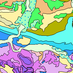
The European Marine Observation and Data Network (EMODnet) consists of more than 100 organisations assembling marine data, products and metadata to make these fragmented data resources more available to public and private users relying on quality-assured, standardised and harmonised marine data which are interoperable and free of restrictions on use. EMODnet is currently in its fourth phase. BGR participates in the EMODnet Geology theme and is coordinating the “seafloor geology” work package from the beginning. In cooperation with the project partners BGR compiles and harmonises GIS data layers on the topics geomorphology, pre-Quaternary and Quaternary geology and provides those, based on INSPIRE principles, via the EMODnet Geology portal https://www.emodnet-geology.eu/map-viewer/. These map layers present the pre-Quaternary and the Quaternary sea-floor geology and Geomorphology of the European Seas, semantically harmonized based on the INSPIRE data specifications for Geology, including the terms for lithology, age, event environment, event process. The data are compiled from the project partners, the national geological survey organizations of the participating countries. The data set represents the most detailed available data compilation of the European Seas using a multi-resolution approach. Data completeness depending on the availability of data and actual mapping campaigns. This open and freely accessible product was made available by the EMODnet Geology project (https://www.emodnet-geology.eu/), implemented by EMODnet Geology Phase IV partners, and funded by the European Commission Directorate General for Maritime Affairs and Fisheries. These data were compiled by BGR from the EMODnet IV Geology partners. All ownership rights of the original data remain with the data originators, who are acknowledged within the attribute values of each map feature.
-
The European Marine Observation and Data Network (EMODnet) consists of more than 100 organisations assembling marine data, products and metadata to make these fragmented data resources more available to public and private users relying on quality-assured, standardised and harmonised marine data which are interoperable and free of restrictions on use. EMODnet is currently in its fourth phase. BGR participates in the EMODnet Geology theme and is coordinating the “seafloor geology” work package from the beginning. In cooperation with the project partners BGR compiles and harmonises GIS data layers on the topics geomorphology, pre-Quaternary and Quaternary geology and provides those, based on INSPIRE principles, via the EMODnet Geology portal https://www. emodnet-geology.eu/map-viewer/. These map layers present the pre-Quaternary and Quaternary sea-floor geology and Geomorphology of the European Seas, semantically harmonized based on the INSPIRE data specifications including the terms for lithology, age, event environment, event process and geomorphology. The data are compiled from the project partners, the national geological survey organizations of the participating countries. The data set represents the most detailed available data compilation of the European Seas using a multiresolution approach. Data completeness depending on the availability of data and actual mapping campaigns. This open and freely accessible product was made available by the EMODnet Geology project (https://www.emodnet-geology.eu/), implemented by EMODnet Geology Phase IV partners, and funded by the European Commission Directorate General for Maritime Affairs and Fisheries. These data were compiled by BGR from the EMODnet IV Geology partners. All ownership rights of the original data remain with the data originators, who are acknowledged within the attribute values of each map feature.
-
1. Berichte zu geologischen Sachverhalten der Sedimentverteilung in ausgewählten Bereichen der Ostsee 2. Berichte, Gutachten und Stellungnahmen zur Erkundung von Ostseekiesen im Schelfbereich
-
Der Band Nr. 10 aus der Publikationsreihe „Fortschritte in der Geologie von Rheinland und Westfalen“ beinhaltet Vorträge mit Diskussionen über ein Internationales Symposium zum Thema „Unterscheidungsmöglichkeiten mariner und nichtmariner Sedimente“, das vom 2. bis 5. Mai 1962 in Düsseldorf stattfand. Eingehend betrachtet wurden dabei die biologischen, geochemischen und mineralogischen Kriterien, welche zur Differenzierung der Sedimente und Sedimentgesteine herangezogen werden können. [1963. 482 S., 93 Abb., 93 Tab., 10 Taf.; ISBN 978-3-86029-810-7]
-
In Verbindung mit Küstenschutzmaßnahmen je nach Örtlichkeit und Themen.
-
1. Geologische Karte der westlichen Ostsee - Karte der quartären Bildungen an der Meeresbodenoberfläche und Karte der quartären Bildungen bis 5 m Tiefe im Maßstab 1:200 000 (Bereich Südrügen - Nordusedom) 2. Karte der Sedimentverteilungen in der westlichen Ostsee im Maßstab 1:500 000 Zusätzliche Informationen Datengewinnung: analog, liegt vor als: Karte, beziehbar: analog
-
The Geological Map of Germany 1:1,000,000 (GK1000) represents the geology of Germany and adjacent areas. The Quaternary units of Northern Germany and the Alpine foreland are described by their genesis.The older sedimentary rocks are classified by age (stratigraphy); igneous and metamorphic rocks are classified by their composition (lithology).