 www.geodatenkatalog.de (S3L)
Keyword
Verwerfung
19 record(s)
Provided by
Type of resources
Available actions
Topics
Keywords
Contact for the resource
Update frequencies
Service types
-
The European Marine Observation and Data Network (EMODnet) consists of more than 100 organisations assembling marine data, products and metadata to make these fragmented data resources more available to public and private users relying on quality-assured, standardised and harmonised marine data which are interoperable and free of restrictions on use. EMODnet is currently in its fourth phase. BGR participates in the EMODnet Geology theme and is coordinating the “seafloor geology” work package from the beginning. In cooperation with the project partners BGR compiles and harmonises GIS data layers on the topics geomorphology, pre-Quaternary and Quaternary geology and provides those, based on INSPIRE principles, via the EMODnet Geology portal https://www. emodnet-geology.eu/map-viewer/. These map layers present the pre-Quaternary and Quaternary sea-floor geology and Geomorphology of the European Seas, semantically harmonized based on the INSPIRE data specifications including the terms for lithology, age, event environment, event process and geomorphology. The data are compiled from the project partners, the national geological survey organizations of the participating countries. The data set represents the most detailed available data compilation of the European Seas using a multiresolution approach. Data completeness depending on the availability of data and actual mapping campaigns. This open and freely accessible product was made available by the EMODnet Geology project (https://www.emodnet-geology.eu/), implemented by EMODnet Geology Phase IV partners, and funded by the European Commission Directorate General for Maritime Affairs and Fisheries. These data were compiled by BGR from the EMODnet IV Geology partners. All ownership rights of the original data remain with the data originators, who are acknowledged within the attribute values of each map feature.
-
The European Marine Observation and Data Network (EMODnet) consists of more than 100 organisations assembling marine data, products and metadata to make these fragmented data resources more available to public and private users relying on quality-assured, standardised and harmonised marine data which are interoperable and free of restrictions on use. EMODnet is currently in its fourth phase. BGR participates in the EMODnet Geology theme and is coordinating the “seafloor geology” work package from the beginning. In cooperation with the project partners BGR compiles and harmonises GIS data layers on the topics geomorphology, pre-Quaternary and Quaternary geology and provides those, based on INSPIRE principles, via the EMODnet Geology portal https://www.emodnet-geology.eu/map-viewer/. These map layers present the pre-Quaternary and the Quaternary sea-floor geology and Geomorphology of the European Seas, semantically harmonized based on the INSPIRE data specifications for Geology, including the terms for lithology, age, event environment, event process. The data are compiled from the project partners, the national geological survey organizations of the participating countries. The data set represents the most detailed available data compilation of the European Seas using a multi-resolution approach. Data completeness depending on the availability of data and actual mapping campaigns. This open and freely accessible product was made available by the EMODnet Geology project (https://www.emodnet-geology.eu/), implemented by EMODnet Geology Phase IV partners, and funded by the European Commission Directorate General for Maritime Affairs and Fisheries. These data were compiled by BGR from the EMODnet IV Geology partners. All ownership rights of the original data remain with the data originators, who are acknowledged within the attribute values of each map feature.
-

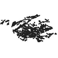
Verwerfungen sind ein wichtiger Bestandteil der Geologischen Karte von Baden-Württemberg. Insgesamt wird zwischen vier verschiedenen Arten von Verwerfungen differenziert: Abschiebung (normal fault); Störung (fault); Blattverschiebung (strike slip fault); Auf- und Überschiebung (reverse fault). Der Geometrietyp ist Linie.
-
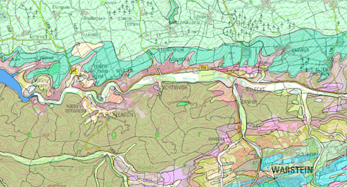
Dieser WMS stellt das Informationssystem Geologische Karte von Nordrhein-Westfalen 1:100.000 [IS GK 100] dar. Die Karte zeigt landesweit die Verbreitung der Gesteine in den Themenlayern Geologische Schichten; Geologische Deckschichten bis 2 Meter Tiefe; Tektonische Verwerfungen.
-
Dieser INSPIRE-Downloaddienst stellt die für das INSPIRE-Thema Geologie aufbereiteten Daten des Informationssystems Geologische Karte von Nordrhein-Westfalen 1:100.000 [IS GK 100] bereit. Die Karte zeigt landesweit die Verbreitung der Gesteine in den Themenlayern Geologische Schichten und Tektonische Verwerfungen.
-
Dieser Dienst stellt für das INSPIRE-Thema Geologie aus der geologischen Karte im Maßstab 1:100000 umgesetzte Daten, des Landesamt für Umwelt- und Arbeitsschutz bereit.:Dieser Layer visualisiert die räumlichen MappedFeature-Objekte der saarländischen Geologischen Daten (GK100), deren Spezifikationseigenschaft vom Typ ShearDisplacementStructure ist. Die Datengrundlage erfüllt die INSPIRE Datenspezifikation.
-
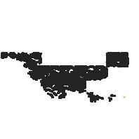
Dieser Dienst stellt für das INSPIRE-Thema Geologie aus der geologischen Karte im Maßstab 1:25000 umgesetzte Daten, des Landesamt für Umwelt- und Arbeitsschutz bereit.:Dieser Layer visualisiert die räumlichen MappedFeature-Objekte der saarländischen Geologischen Daten (GK25), deren Spezifikationseigenschaft vom Typ ShearDisplacementStructure ist. Die Datengrundlage erfüllt die INSPIRE Datenspezifikation.
-
Der Datensatz stellt geologische Fachdaten aus dem Informationssystem Geologische Karte von Nordrhein-Westfalen 1:100.000 [IS GK 100] für das INSPIRE-Thema Geologie dar. Die Karte zeigt landesweit die Verbreitung der geologischen Einheiten der GK 100 zu den Themen Chronostratigraphie, Lithologische Zusammensetzung und Tektonische Verwerfungen. Die Deckschichten werden nicht dargestellt.
-
Der Datensatz zum Informationssystem Geologische Karte von Nordrhein-Westfalen 1:50.000 [IS GK 50] ist das Ergebnis der Integrierten Geologischen Landesaufnahme (IGL) und stellt blattschnittfrei geologische Fachdaten über Alter, Beschaffenheit und Verbreitung der Gesteine zur Verfügung. Das Kartenwerk ist Planungsgrundlage bei großräumigen Nutzungsvorhaben der Landesplanung: Rohstoffgewinnung, Baugrundsicherung, Grundwassererschließung oder Ausweisung von Naturschutzgebieten. Verfügbare Kartenthemen: Geologische Detaildarstellung, Lithologie, Höhenlinien der Quartär-Basis, Präquartärer Untergrund, Geologische Schnitte sowie weitere projektabhängige Themen. Der Datensatz befindet sich im Aufbau und ist nicht flächendeckend.