 www.geodatenkatalog.de (S3L)
Keyword
Arktis
16 record(s)
Provided by
Type of resources
Available actions
Topics
Keywords
Contact for the resource
Service types
-
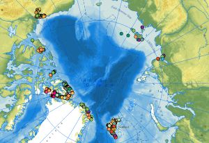
The web service of the dataset comprises the locations of outcrops with respective information on the lithology, stratigraphy, rock age and tectonic data collected during the CASE expeditions. The data attributes include stereographic projections and sketches of tectonic structures derived from the outcrop data. At the end of the 1980s, BGR initiated the research program Circum-Arctic Structural Events (CASE) to reconstruct the plate tectonic processes during the evolution of the Arctic Ocean using terrestrial data from the surrounding continental margins. One of the scientific questions of the CASE programme is as simple as it is complex: How did the Arctic Ocean, this large basin between the Eurasian and North American continental plates, develop? There are still no conclusive answers to this question in terms of plate tectonics. In contrast to the marine expeditions of geophysicists in the Arctic Ocean, geologists on land along the various coastal areas of the Arctic Ocean can directly touch, examine and map rocks, structures, folds and fault zones and determine the respective ages of the movements. This makes it possible to directly compare rock units and deformation zones on different continental plates and thus also to reconstruct when these plates collided, how long they remained next to each other and when and how they separated again. Since the inception of BGR’s Arctic research, the primary focus and research areas have been along the continental margins between Spitsbergen and the Canadian Arctic Archipelago via Greenland, to the Yukon North Slope on the border with Alaska. On the opposite side of the Arctic Ocean, there have been expeditions to Yakutia, the mainland areas near the Laptev Sea, the New Siberian Islands and to the Polar Ural with Russian partners. An important method for the interpretation of the geological evolution of the Arctic is the examination of tectonic structures (faults, folds, cleavage etc.), the determination of the kinematics and the age of the tectonic movements.
-
The study of the geodynamic evolution of the Arctic continental margin and opening of the Arctic Ocean represents a primary target of BGR research and is studied within the frame of the CASE programme. In addition to onshore geological investigations, BGR conducts airborne aeromagnetic surveys. The available service contains the results of aeromagnetic surveys from the CASE program as well as cooperation projects (PMAP, NARES & NOGRAM), which were obtained with helicopters or fixed-wing aircraft in the Arctic.
-
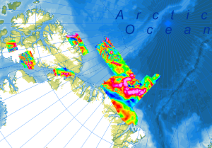
As part of the PMAP-CASE (Polar Margin Aeromagnetic Program - Circum-Arctic Structural Events) expeditions, two surveys were conducted in consecutive seasons in 1997 and 1998. Cooperating partners were the Department of National Defence (DND), GSC Ottawa and the Institute for Aerospace Research Ottawa (IAR-NRC). The surveys covered the areas of the northern continental margin of Greenland including the northern Nansen Land and western Johannes V. Jensen Land, as well as parts of the Lincoln Sea. The objective of the campaigns was to investigate the structures of the upper crust of the Morris Jesup Plateau and the correlation of magnetic anomalies with known structures and geologic units on land (Franklinian Basin, Kap Washington volcanics, and volcanic dyke swarms). Airborne magnetic surveys (Convair 580) were conducted with a 3 km flight line spacing, and control lines were flown every 30 km. Data were recorded at a constant flight altitude of 300 m above ground. Approximately 30000 km of line data were collected during the two expeditions, covering an area of 73000 km².
-
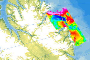
As part of the expedition CASE 20, geological fieldwork and an aeromagnetic survey were conducted in order to study the architecture and structure of the present continental margin of Northeast Greenland. The helicopter-borne magnetic survey in July and August 2018 covered the coastal areas between Independence Fiord and Kronprins Christian Land. During a 2-weeks period nearly 6500 km of aeromagnetic line data were collected covering an area of 17000 km². The distance between the individual lines was 4 km and control profiles were flown every 20-30 km. The aeromagnetic data were recorded by a magnetometer, which was towed approx. 30 m beneath the helicopter.
-
During the German-Canadian Nares Strait Expedition in 2001, an aeromagnetic survey was carried out across the northern part of the Nares Strait including the Hall Basin, Judge Daly Promontory and in Robeson Channel in cooperation with the Canadian GSC. The aim of the research was to detect and localize the Wegener Fault, a transform fault between Ellesmere Island and NW Greenland, which is closely linked to the opening of the North Atlantic and the Arctic Ocean. The helicopter-borne magnetic survey NARES I (Robeson Channel) was carried out with a flight line spacing of 2 km, and control profiles were flown every 10 km. During the expedition, 5470 km of line data were collected. The aeromagnetic data were recorded by a magnetometer, which was towed approx. 25 m beneath the helicopter and recorded at a constant altitude of 305 m (1000 ft) above ground.
-
The study of the geodynamic evolution of the Arctic continental margin and opening of the Arctic Ocean represents a primary target of BGR research and is studied within the frame of the CASE programme. In addition to onshore geological investigations, BGR conducts airborne aeromagnetic surveys. The available series contains the results of aeromagnetic surveys from the CASE program as well as cooperation projects (PMAP, NARES & NOGRAM), which were obtained with helicopters or fixed-wing aircraft in the Arctic.
-
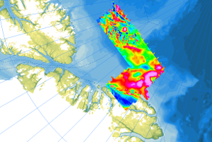
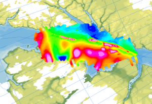
Onshore geological field work combined with an onshore/offshore aeromagnetic survey was carried out during a joint expedition of the German BGR and the Canadian GSC to understand the structural architecture of the North American continental margin. The helicopter-borne magnetic survey of 2008 covered the northern coastal areas of Ellesmere Island and the adjacent marine areas. The survey was conducted with a line separation of 2 km and covered a 40 to 50 km wide swath offshore about parallel to the north coast of Ellesmere Island from Yelverton Bay in the west to Parr Bay east of Cape Columbia, the northernmost point of Canada. Between Yelverton Bay and M'Clintock Inlet, the survey extended about 40 to 50 km inland, which was the prime target area of the CASE 11 geological investigations. This section of mountainous terrain was flown in a “draped” mode to keep the distance to ground at approximately 1500 ft, same as over the offshore areas. During a 4-weeks period in May/June 2008, close to 8000 km of aeromagnetic line data were acquired, covering an area of 12000 km².
-
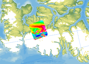
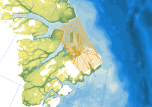
As part of the CASE 12 expedition, geological fieldwork and an aeromagnetic survey were conducted on Ellesmere Island (Canadian Arctic) in the summer of 2011. The helicopter-borne magnetic survey covered the ice-free areas between Vendom Fiord and Strathcona Fiord in the west and the ice-covered mountain ranges of the Inglefield Uplift in the east. With a total flight time of approx. 35 hours, 4200 line kilometres were flown covering a total area of 6000 km². The distance between the individual lines was 2 km, and control profiles perpendicular to the individual lines were flown every 10 km. The aeromagnetic data were recorded by a magnetometer, which was towed approx. 30 m beneath the helicopter.
-
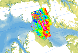
In May/June 2001, as part of the expedition NARES I, an aeromagnetic survey was carried out in the area of the eastern Kane Basin in cooperation with the Canadian GSC, in addition to the survey over the Robeson Channel and parallel to marine geophysical investigations with the Canadian icebreaker Louis S. St. Laurent. Another survey, NARES II, was conducted from Alexandra Fiord in 2003 and covered coastal areas of Ellesmere Island and the western Kane Basin. The aim of the research was to detect and localize the Wegener Fault, a transform fault between Ellesmere Island and NW Greenland, which is closely linked to the opening of the North Atlantic and the Arctic Ocean. The helicopter-borne magnetic surveys NARES I + II (Kane Basin) were carried out with a flight line spacing of 2 km, and control profiles were flown every 10 km. During the two expeditions, 11806 km of line data were collected (3573 km in 2001, and 8333 km in 2003), covering an area of approximately 20000 km². The aeromagnetic data were recorded by a magnetometer, which was towed approx. 25 m beneath the helicopter.
-
The dataset comprises the locations of outcrops with respective information on the lithology, stratigraphy, rock age and tectonic data collected during the CASE expeditions. The data attributes include stereographic projections and sketches of tectonic structures derived from the outcrop data. At the end of the 1980s, BGR initiated the research program Circum-Arctic Structural Events (CASE) to reconstruct the plate tectonic processes during the evolution of the Arctic Ocean using terrestrial data from the surrounding continental margins. One of the scientific questions of the CASE programme is as simple as it is complex: How did the Arctic Ocean, this large basin between the Eurasian and North American continental plates, develop? There are still no conclusive answers to this question in terms of plate tectonics. In contrast to the marine expeditions of geophysicists in the Arctic Ocean, geologists on land along the various coastal areas of the Arctic Ocean can directly touch, examine and map rocks, structures, folds and fault zones and determine the respective ages of the movements. This makes it possible to directly compare rock units and deformation zones on different continental plates and thus also to reconstruct when these plates collided, how long they remained next to each other and when and how they separated again. Since the inception of BGR’s Arctic research, the primary focus and research areas have been along the continental margins between Spitsbergen and the Canadian Arctic Archipelago via Greenland, to the Yukon North Slope on the border with Alaska. On the opposite side of the Arctic Ocean, there have been expeditions to Yakutia, the mainland areas near the Laptev Sea, the New Siberian Islands and to the Polar Ural with Russian partners. An important method for the interpretation of the geological evolution of the Arctic is the examination of tectonic structures (faults, folds, cleavage etc.), the determination of the kinematics and the age of the tectonic movements.