 My GeoNetwork catalogue
Bodenverbreitung
Provided by
Type of resources
Available actions
Topics
Keywords
Contact for the resource
Update frequencies
Service types
-
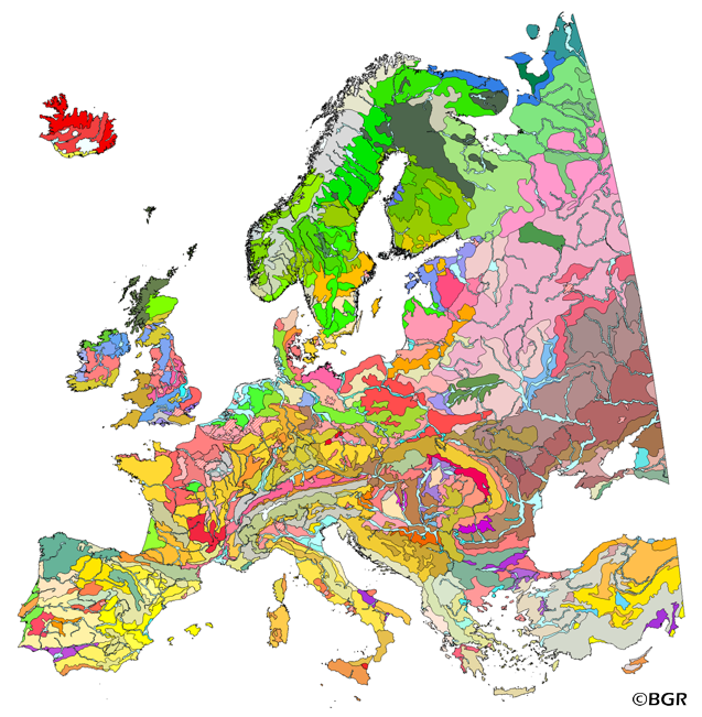
The map of the "Soil Regions of the European Union and Adjacent Countries 1:5,000,000 (Version 2.0)" is published by the Federal Institute of Geosciences and Natural Resources (BGR), in partnership with the Joint Research Center (JRC, Ispra). The soil regions map is intended to support the current national mapping activities towards a European 1:250,000 datbase by stratifying similar regional soil associations into a hierarchical concept. Only by stratification, the complexity of soils can be systematically structured so that the complex 1:250,000 legend can be handled in cross-national and contintental-level applications. Soil regions are natural, cross-regional soil geographical units which perform the highest spatial and content-based aggregation of European soils. They represent the frame conditions for soil development at the landscape level. The soil regions are presented at scale 1:5,000,000. Thus, its borders are highly generalized. Because of its low resolution, the map units absorb atypical soils and associations of soils, which are only described in higher resolution soil maps. The delineation of the soil regions is expected to be refined (and probably improved by its content) during the actual 1:250,000 mapping process. Thus, updating can be expected in the future. Currently, the soil regions map is the only graphical soil representation in Europe which has been developed using fully comparable and harmonized basic data at the continental level (climate, hydrography, relief, geology, vegetation): the interpretation of this input data, and the utilization of expert knowledge (including the interpretation of regional soil maps) has been done using one common methodology, developed and applied consistently throughout the whole mapping area by an experienced international soil mapper (Dr. Reinhard Hartwich, former member of BGR, and co-author of the 1998 Manual of Procedures). The methodology is extensively described in the Explanatory Notes (German), and in the revised Manual of Procedures which is expected to be completed soon. It is highly recommended to apply and interpret the map using the map comments and descriptions as provided in the explanatory notes (German: Hartwich et al. 2005; English: revision of the Manual of Procedures, initial version: Finke et al. 2001).
-
The map of the "Soil Regions of the European Union and Adjacent Countries 1 : 5 000 000 (Version 2.0)" is published by the Federal Institute of Geosciences and Natural Resources (BGR), in partnership with the Joint Research Center (JRC, Ispra). The soil regions map is intended to support the current national mapping activities towards a European 1:250,000 datbase by stratifying similar regional soil associations into a hierarchical concept. Only by stratification, the complexity of soils can be systematically structured so that the complex 1:250.000 legend can be handled in cross-national and contintental-level applications. Soil regions are natural, cross-regional soil geographical units which perform the highest spatial and content-based aggregation of European soils. They represent the frame conditions for soil development at the landscape level. The soil regions are presented at scale 1:5,000,000. Thus, its borders are highly generalized. Because of its low resolution, the map units absorb atypical soils and associations of soils, which are only described in higher resolution soil maps. The delineation of the soil regions is expected to be refined (and probably improved by its content) during the actual 1:250,000 mapping process. Thus, updating can be expected in the future. Currently, the soil regions map is the only graphical soil representation in Europe which has been developed using fully comparable and harmonized basic data at the continental level (climate, hydrography, relief, geology, vegetation): the interpretation of this input data, and the utilization of expert knowledge (including the interpretation of regional soil maps) has been done using one common methodology, developed and applied consistently throughout the whole mapping area by an experienced international soil mapper (Dr. Reinhard Hartwich, former member of BGR, and co-author of the 1998 Manual of Procedures). The methodology is extensively described in the Explanatory Notes (German), and in the revised Manual of Procedures which is expected to be completed soon.
-
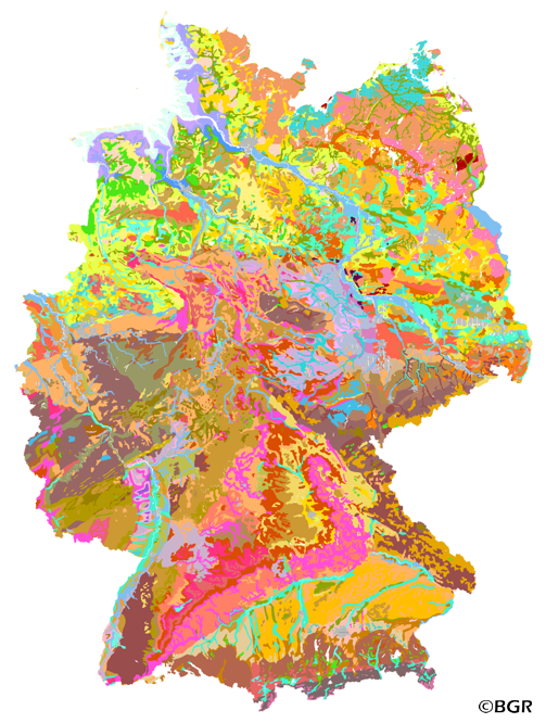
Web Map Service (WMS) of the BUEK1000. The first country wide soil map at a scale of 1:1,000,000 (BUEK1000) has been compiled on the basis of published soil maps of the former German Democratic Republic and the pre 1990 federal states of Germany. To do this, it was necessary to match the soil systems used in East and West Germany and to develop standardized descriptions of soil units. A relatively homogeneous map has resulted, which permits uniform assessment of the soils throughout Germany. The map shows 71 soil mapping units, described in the legend on the basis of the German and FAO soil systems. Each soil unit has been assigned a characteristic soil profile (Leitprofil) as an aid to map interpretation. For the first time the subdivision of the country into 12 soil regions has been represented on the map. This subdivision was coordinated with the state Geological Surveys. These soil regions will represent the highest hierarchic level of nation wide soil maps in future. The colours of soil units correspond to the standards of the 'Bodenkundliche Kartieranleitung' (KA 3; Guidelines for Soil Mapping). The various hues characterize differences in relief or soil humidity. The BUEK1000 was produced digitally. It is an important part of the spatial database integrated in the Soil Information System currently being established at the Federal Institute for Geosciences and Natural Resources (FISBo BGR). It can be used together with the characteristic soil profiles to derive thematic maps related to nation wide soil protection. The scale of the BUEK1000 makes it especially suitable for small scale evaluations at federal or EU level.
-
The first country wide soil map at a scale of 1:1,000,000 (BUEK1000) has been compiled on the basis of published soil maps of the former German Democratic Republic and the pre 1990 federal states of Germany. To do this, it was necessary to match the soil systems used in East and West Germany and to develop standardized descriptions of soil units. A relatively homogeneous map has resulted, which permits uniform assessment of the soils throughout Germany. The map shows 71 soil mapping units, described in the legend on the basis of the German and FAO soil systems. Each soil unit has been assigned a characteristic soil profile (Leitprofil) as an aid to map interpretation. For the first time the subdivision of the country into 12 soil regions has been represented on the map. This subdivision was coordinated with the state Geological Surveys. These soil regions will represent the highest hierarchic level of nation wide soil maps in future. The colours of soil units correspond to the standards of the 'Bodenkundliche Kartieranleitung' (KA 3; Guidelines for Soil Mapping). The various hues characterize differences in relief or soil humidity. The BUEK1000 was produced digitally. It is an important part of the spatial database integrated in the Soil Information System currently being established at the Federal Institute for Geosciences and Natural Resources (FISBo BGR). It can be used together with the characteristic soil profiles to derive thematic maps related to nation wide soil protection. The scale of the BUEK1000 makes it especially suitable for small scale evaluations at federal or EU level.
-
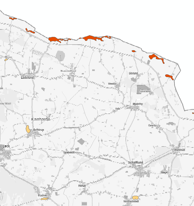
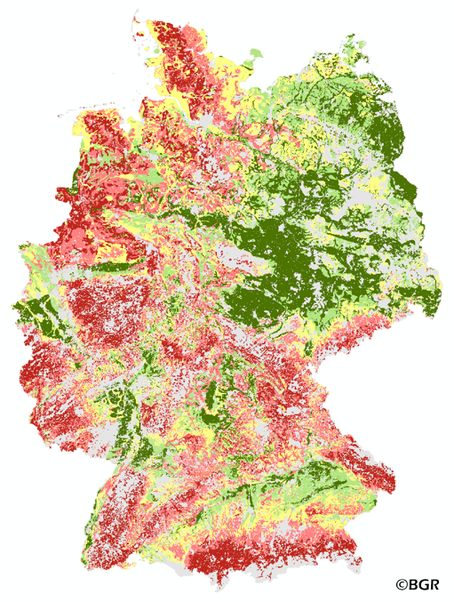
Abbildung der Flächen, mit Auftreten von Böden mit besonders ausgeprägten Archivfunktionen. Die Karte stellt den vollständigen Auszug aus dem Archivbodenkataster des Geologischen Dienstes dar. Die Auswahl erfolgte nach folgenden Kriterien: * Bodenentwicklungen, in denen sich Prozesse und Phasen der Naturgeschichte in besonderer Art und Weise widerspiegeln * Bodenentwicklungen, die in ihrem landschaftlichen Zusammenhang und Wirkungsgefüge durch eine besondere Stoffverlagerung gekennzeichnet sind * Bodenentwicklungen, die Phasen, Ereignisse und Vorgänge der Kulturgeschichte repräsentieren. Die Abgrenzung der Flächen erfolgte in der Regel auf der Grundlage von konkreten Punktaufnahmen, Flächenabgrenzungen in Bodenkarten oder Geologischen Karten sowie Daten zum Relief.
-
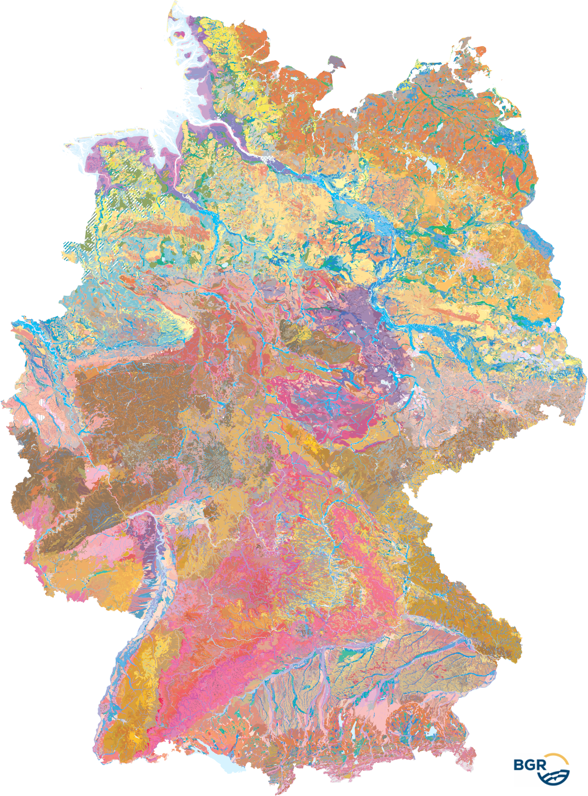
Small-scale soil maps at scales of 1:200,000 to 1:5,000,000 are usually compiled from large- or medium-scale soil maps by summarizing the soil units depicted there. A uniform pedoregional classification is required to ensure a comparable approach across regions. The presented data set at the aggregation level of the soil landscapes covers the 36 most important soil-relevant lithogenetic units in Germany and is based on the map of the soil landscapes at a scale of 1:250,000, version 1.4, which in turn was derived from the BUEK200/BUEK250. For the map scale 1:5,000,000 the units were generalized. More detailed information on the soil regions and soil landscapes of the Federal Republic of Germany can be found in the Soil Mapping Guide (KA5), Chapter 6.5 from page 335.
-
The exchange frequency of water in soils describes how often water and the dissolved substances in it can be replaced in a soil layer during the annual leachate flow. Small water storage capacity means high replacement frequency. The risk of the discharge of easily detachable materials like nitrate is given at high exchange rates.
-
- projektbezogene Erstellung von bodenkundlichen Karten im Maßstab kleiner M 1:25000 - Kartierung zu speziellen bodenkundlichen Fragestellungen, z.B. Erosion, Versauerung, Nährstoffbelastung von Böden
-
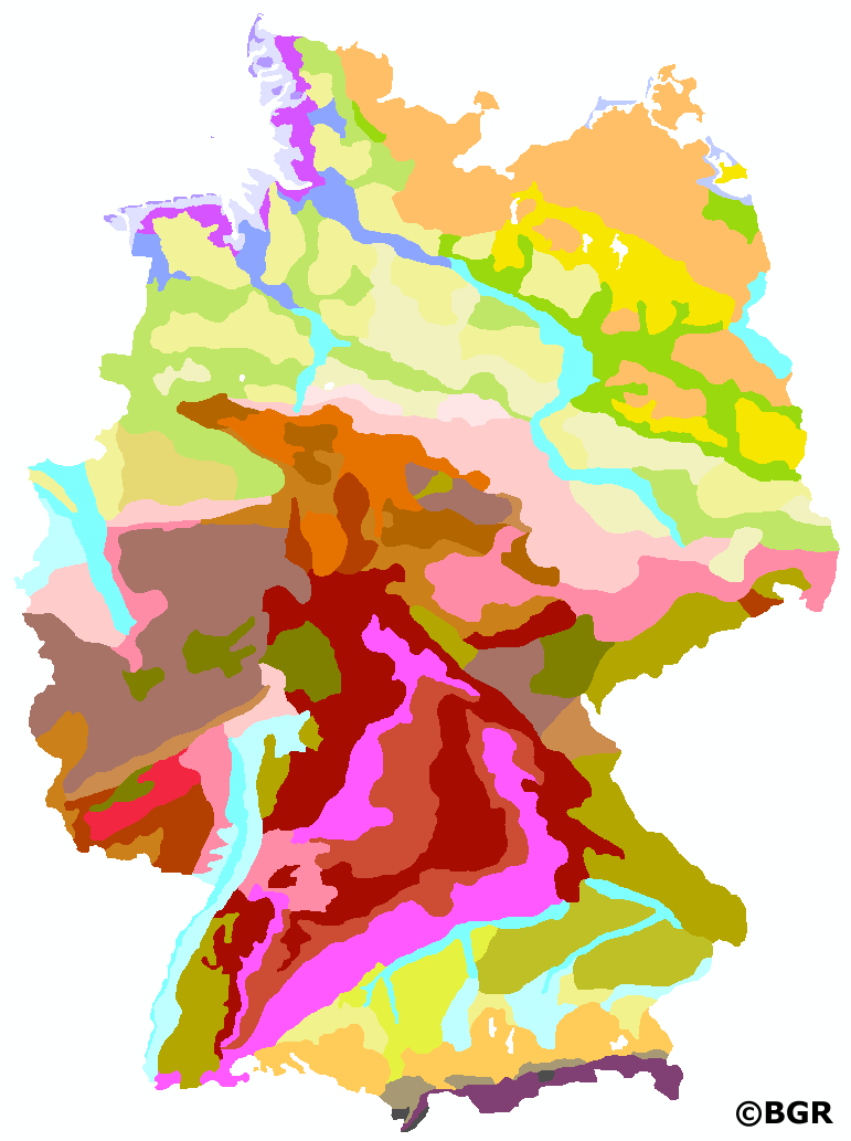
The Soil Map 1:250,000 (BUEK250), the digital successor to the Soil Map 1:200,000 (BUEK200), provides a detailed, nationwide standardized and comprehensive information basis for cross-state statements on soil use and soil protection in Germany. The present graphic dataset, version 6.0, is essentially based on the BUEK200, which was developed by the Federal Institute for Geosciences and Natural Resources (BGR) in cooperation with the State Geological Surveys (SGD) of the federal states. It is graphically free of sheet sections and describes the distribution and association of soils on the basis of a total of 2171 legend units. The detailed pedological information is stored separately in a relational database and can be linked to the BUEK250 graphic dataset via the GEN_ID data field.
-
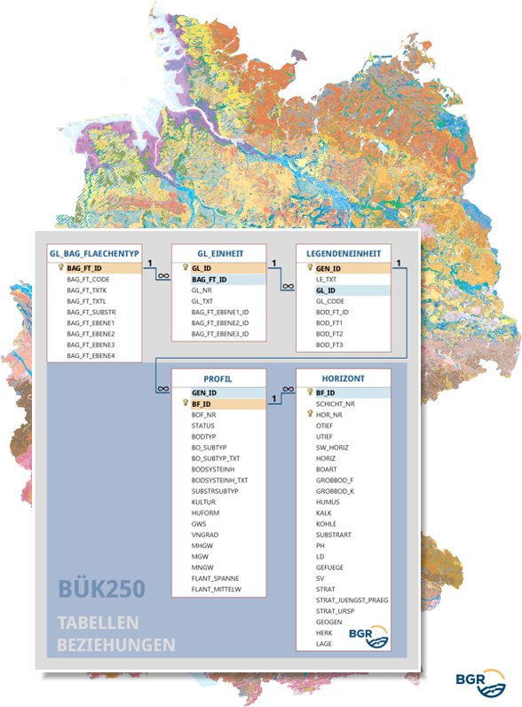
The new 1.0 version of the Soil Map 1:250,000 (BUEK250) database has its origins in the provisional BUEK200 database (version 0.8), which was developed in cooperation with the State Geological Surveys (SGD) of the federal states. It contains the pedological information of the 2171 legend units of the BUEK250, which can be linked to the areas of the graphic dataset of the BUEK250 via the GEN_ID data field. All the profile and horizon data of the dominant and associated soils are assigned to these legend units. Accordingly, thematic evaluations are carried out using the data fields of the corresponding database tables PROFILE and HORIZONT. The LEGENDENEINHEIT table contains, among other things, the textual descriptions of the BUEK250 legend units. Two additional tables (GL_EINHEIT, GL_BAG_FLAECHENTYP) can be used to assign the legend units to general legend units and to hierarchically structured surface types of the soil parent material.