 My GeoNetwork catalogue
Bodeneigenschaften
Provided by
Type of resources
Available actions
Topics
Keywords
Contact for the resource
Update frequencies
Service types
-
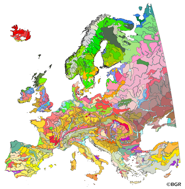
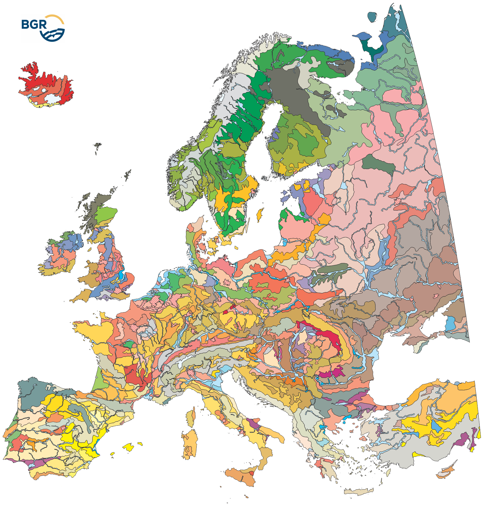
The map of the "Soil Regions of the European Union and Adjacent Countries 1:5,000,000 (Version 2.0)" is published by the Federal Institute of Geosciences and Natural Resources (BGR), in partnership with the Joint Research Center (JRC, Ispra). The soil regions map is intended to support the current national mapping activities towards a European 1:250,000 datbase by stratifying similar regional soil associations into a hierarchical concept. Only by stratification, the complexity of soils can be systematically structured so that the complex 1:250,000 legend can be handled in cross-national and contintental-level applications. Soil regions are natural, cross-regional soil geographical units which perform the highest spatial and content-based aggregation of European soils. They represent the frame conditions for soil development at the landscape level. The soil regions are presented at scale 1:5,000,000. Thus, its borders are highly generalized. Because of its low resolution, the map units absorb atypical soils and associations of soils, which are only described in higher resolution soil maps. The delineation of the soil regions is expected to be refined (and probably improved by its content) during the actual 1:250,000 mapping process. Thus, updating can be expected in the future. Currently, the soil regions map is the only graphical soil representation in Europe which has been developed using fully comparable and harmonized basic data at the continental level (climate, hydrography, relief, geology, vegetation): the interpretation of this input data, and the utilization of expert knowledge (including the interpretation of regional soil maps) has been done using one common methodology, developed and applied consistently throughout the whole mapping area by an experienced international soil mapper (Dr. Reinhard Hartwich, former member of BGR, and co-author of the 1998 Manual of Procedures). The methodology is extensively described in the Explanatory Notes (German), and in the revised Manual of Procedures which is expected to be completed soon. It is highly recommended to apply and interpret the map using the map comments and descriptions as provided in the explanatory notes (German: Hartwich et al. 2005; English: revision of the Manual of Procedures, initial version: Finke et al. 2001).
-
The map of the "Soil Regions of the European Union and Adjacent Countries 1 : 5 000 000 (Version 2.0)" is published by the Federal Institute of Geosciences and Natural Resources (BGR), in partnership with the Joint Research Center (JRC, Ispra). The soil regions map is intended to support the current national mapping activities towards a European 1:250,000 datbase by stratifying similar regional soil associations into a hierarchical concept. Only by stratification, the complexity of soils can be systematically structured so that the complex 1:250.000 legend can be handled in cross-national and contintental-level applications. Soil regions are natural, cross-regional soil geographical units which perform the highest spatial and content-based aggregation of European soils. They represent the frame conditions for soil development at the landscape level. The soil regions are presented at scale 1:5,000,000. Thus, its borders are highly generalized. Because of its low resolution, the map units absorb atypical soils and associations of soils, which are only described in higher resolution soil maps. The delineation of the soil regions is expected to be refined (and probably improved by its content) during the actual 1:250,000 mapping process. Thus, updating can be expected in the future. Currently, the soil regions map is the only graphical soil representation in Europe which has been developed using fully comparable and harmonized basic data at the continental level (climate, hydrography, relief, geology, vegetation): the interpretation of this input data, and the utilization of expert knowledge (including the interpretation of regional soil maps) has been done using one common methodology, developed and applied consistently throughout the whole mapping area by an experienced international soil mapper (Dr. Reinhard Hartwich, former member of BGR, and co-author of the 1998 Manual of Procedures). The methodology is extensively described in the Explanatory Notes (German), and in the revised Manual of Procedures which is expected to be completed soon.
-
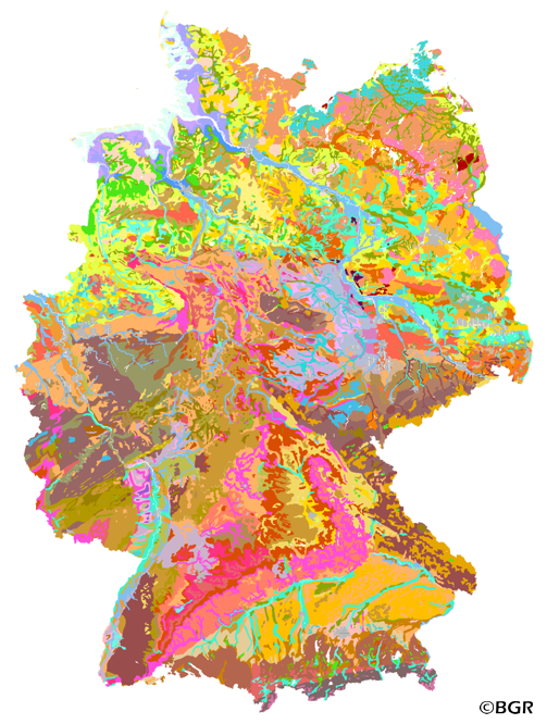
Web Map Service (WMS) of the BUEK1000. The first country wide soil map at a scale of 1:1,000,000 (BUEK1000) has been compiled on the basis of published soil maps of the former German Democratic Republic and the pre 1990 federal states of Germany. To do this, it was necessary to match the soil systems used in East and West Germany and to develop standardized descriptions of soil units. A relatively homogeneous map has resulted, which permits uniform assessment of the soils throughout Germany. The map shows 71 soil mapping units, described in the legend on the basis of the German and FAO soil systems. Each soil unit has been assigned a characteristic soil profile (Leitprofil) as an aid to map interpretation. For the first time the subdivision of the country into 12 soil regions has been represented on the map. This subdivision was coordinated with the state Geological Surveys. These soil regions will represent the highest hierarchic level of nation wide soil maps in future. The colours of soil units correspond to the standards of the 'Bodenkundliche Kartieranleitung' (KA 3; Guidelines for Soil Mapping). The various hues characterize differences in relief or soil humidity. The BUEK1000 was produced digitally. It is an important part of the spatial database integrated in the Soil Information System currently being established at the Federal Institute for Geosciences and Natural Resources (FISBo BGR). It can be used together with the characteristic soil profiles to derive thematic maps related to nation wide soil protection. The scale of the BUEK1000 makes it especially suitable for small scale evaluations at federal or EU level.
-
The first country wide soil map at a scale of 1:1,000,000 (BUEK1000) has been compiled on the basis of published soil maps of the former German Democratic Republic and the pre 1990 federal states of Germany. To do this, it was necessary to match the soil systems used in East and West Germany and to develop standardized descriptions of soil units. A relatively homogeneous map has resulted, which permits uniform assessment of the soils throughout Germany. The map shows 71 soil mapping units, described in the legend on the basis of the German and FAO soil systems. Each soil unit has been assigned a characteristic soil profile (Leitprofil) as an aid to map interpretation. For the first time the subdivision of the country into 12 soil regions has been represented on the map. This subdivision was coordinated with the state Geological Surveys. These soil regions will represent the highest hierarchic level of nation wide soil maps in future. The colours of soil units correspond to the standards of the 'Bodenkundliche Kartieranleitung' (KA 3; Guidelines for Soil Mapping). The various hues characterize differences in relief or soil humidity. The BUEK1000 was produced digitally. It is an important part of the spatial database integrated in the Soil Information System currently being established at the Federal Institute for Geosciences and Natural Resources (FISBo BGR). It can be used together with the characteristic soil profiles to derive thematic maps related to nation wide soil protection. The scale of the BUEK1000 makes it especially suitable for small scale evaluations at federal or EU level.
-
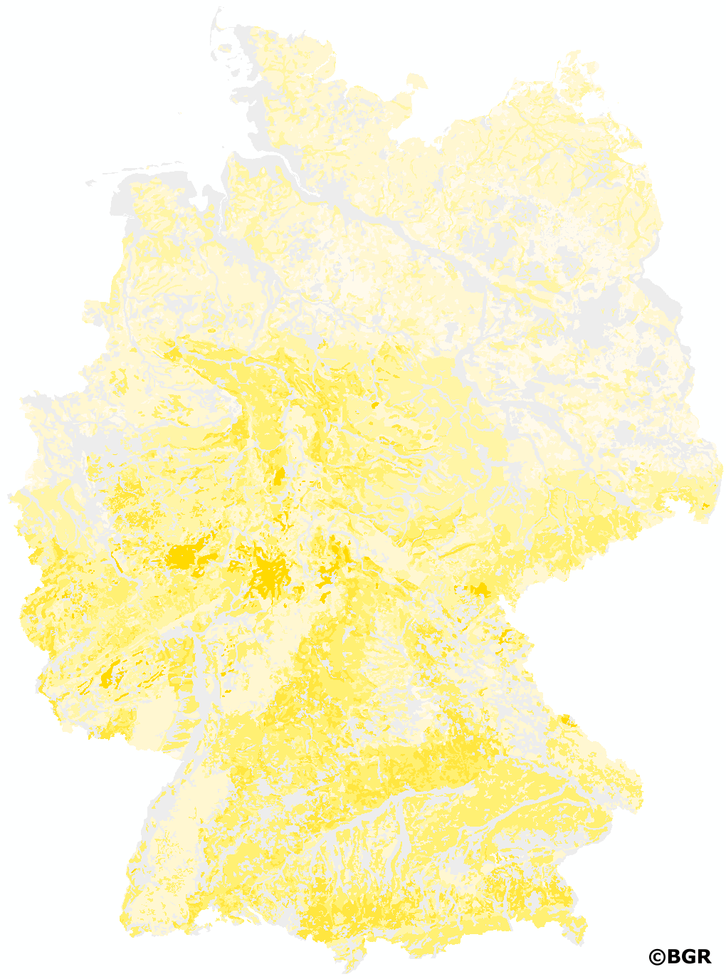
Die Karte Bodeneigenschaften Düngebedarf ist eine Auswertung der digitalen Bodenkarte 1:50.000. Sie ist eigens zur Schätzung der Bodeneigenschaften zum Zwecke der Eingabe in das Bilanzierungs- und Empfehlungssystem Düngung BESyD erstellt. Sie enthält folgende Attribute, bezogen auf eine Bodentiefe von 100 cm und bezeichnet nach Bodenkundlicher Kartieranleitung (5. Auflage): untere Tiefe des Horizonts in Metern (Standardbezug: 1 m), Bodenart, Ton-, Schluff-, Sandanteil (M.-%), Bodenartengruppe, effektive Durchwurzelungstiefe We (dm) und Skelettgehalt, Kürzel der Bodenart nach Bodenschätzung (BS), textliche Beschreibung der Bodenart nach Bodenschätzung, Feinanteil (FA). Die Daten sind auf Feldblockebene als Schätzung verwendbar, wenn keine genaueren Informationen über die Feldansprache oder Laboranalyse vorliegen.
-
New, nationwide background values for 16 heavy metals and trace elements were published by the LABO in 2017. They are based on profile descriptions and measurements of aqua regia extracts, which were combined and homogenized by the BGR. Measurements with high quantification limits were excluded from further evaluation according to certain criteria in order to avoid their influence on the derivation of background values. To prevent the background values from being disproportionately influenced by regions with high sample densities, spatial thinning was partially performed. The values of several horizons of a site were combined to one value by depth-weighted averages. For evaluation, the available measured values were assigned to different groups of soil parent materials. In addition, a distinction was made whether the samples were taken in the topsoil, in the subsoil or in the underground. In the case of topsoil, the different land use (arable land, grassland, forest) was also taken into account for the evaluation. Unconsolidated rocks were evaluated separately for northern and southern Germany due to their different composition. By dividing the data into sub-collectives, reliable case numbers were not achieved in all cases. Consequently, only background values with case numbers ?20 are presented. The exact derivation procedure can be found in the report of the LABO-Bund/Länder-Arbeitsgemeinschaft Bodenschutz (2017): 'Hintergrundwerte für anorganische und organische Stoffe in Böden', 4th revised and supplemented edition.
-
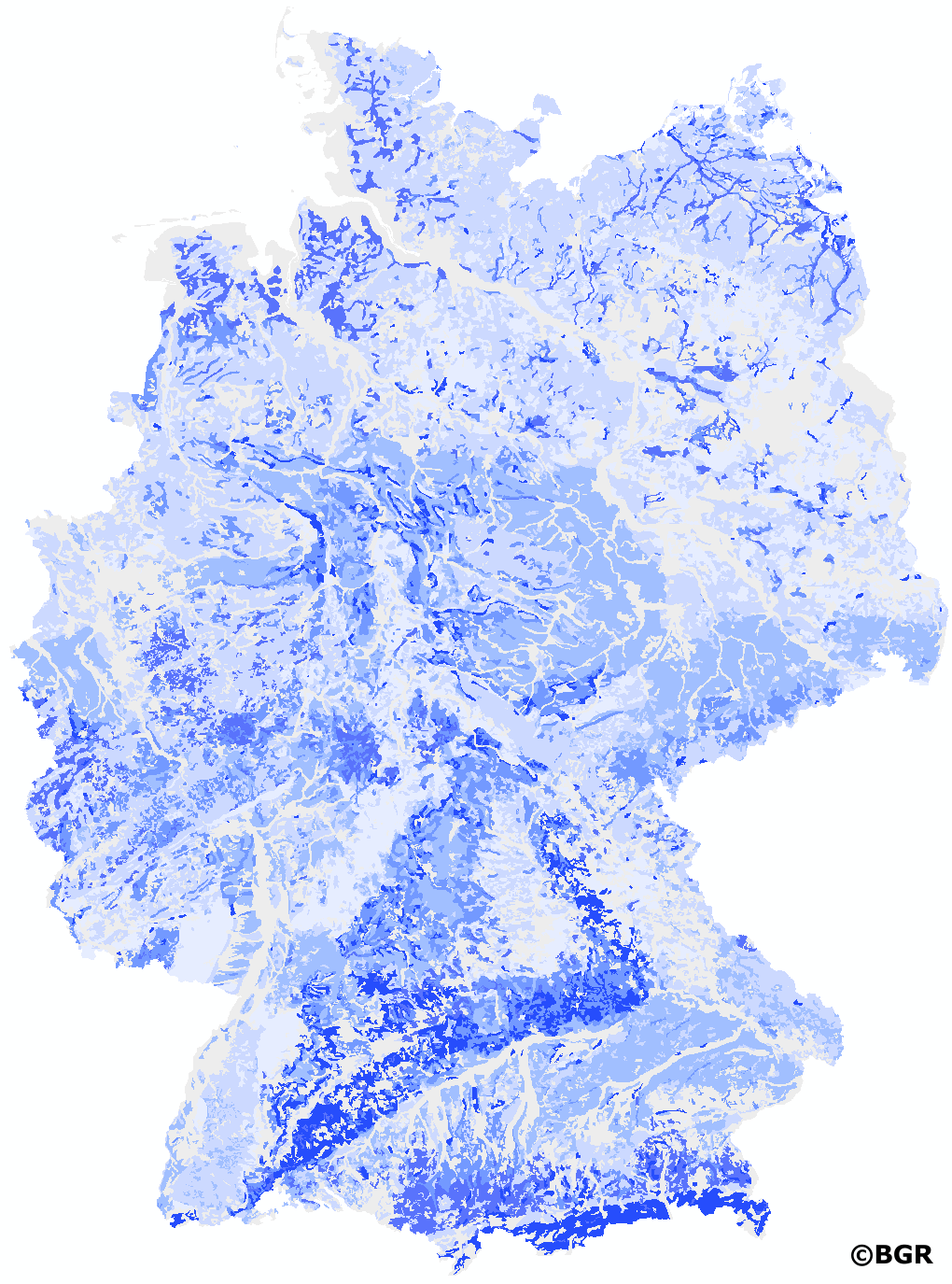
New, nationwide background values for 16 heavy metals and trace elements were published by the LABO in 2017. They are based on profile descriptions and measurements of aqua regia extracts, which were combined and homogenized by the BGR. Measurements with high quantification limits were excluded from further evaluation according to certain criteria in order to avoid their influence on the derivation of background values. To prevent the background values from being disproportionately influenced by regions with high sample densities, spatial thinning was partially performed. The values of several horizons of a site were combined to one value by depth-weighted averages. For evaluation, the available measured values were assigned to different groups of soil parent materials. In addition, a distinction was made whether the samples were taken in the topsoil, in the subsoil or in the underground. In the case of topsoil, the different land use (arable land, grassland, forest) was also taken into account for the evaluation. Unconsolidated rocks were evaluated separately for northern and southern Germany due to their different composition. By dividing the data into sub-collectives, reliable case numbers were not achieved in all cases. Consequently, only background values with case numbers ?20 are presented. The exact derivation procedure can be found in the report of the LABO-Bund/Länder-Arbeitsgemeinschaft Bodenschutz (2017): 'Hintergrundwerte für anorganische und organische Stoffe in Böden', 4th revised and supplemented edition.