 My GeoNetwork catalogue
map
Provided by
Type of resources
Available actions
Topics
Keywords
Contact for the resource
Update frequencies
Service types
-
-

-

-

-
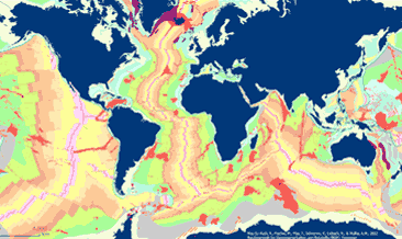
The General Global Map of Seafloor Bedrock Geology (seafloorgeol) shows the global distribution of seafloor bedrock, the boundaries of the continental shelf and continental slope, the axes of the oceanic ridges and other marine geological features. Sedimentary deposits are not shown. The map is based on extracts from Bouysse et al. (2010) © CGMW, and Bryan & Ernst (2008) using Esri Basemap, HERE, Garmin, FAO, NOAA, USGS, © OpenStreetMap contributors and the GIS User Community.
-
Der Web Map Service (WMS) Mautstraßen stellt für das Bundesland Hamburg die mautpflichtigen Strecken auf den Bundesautobahnen und Bundesstraßen bereit. Zur genaueren Beschreibung der Daten und Datenverantwortung nutzen Sie bitte den Verweis zur Datensatzbeschreibung.
-
Web Map Service (WMS) zum Thema Historische Karten 1:5000. Zur genaueren Beschreibung der Daten und Datenverantwortung nutzen Sie bitte den Verweis zur Datensatzbeschreibung.
-
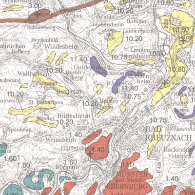
In order to exploit mineral raw materials close to the Earth's surface, experts are working on trans-regional and national planning documents. To do this, they need maps which clearly depict the raw materials close to the surface in Germany. KOR200 displays Germany's national raw material potential in a comparable way, thus forming a basis for future exploration and investigations as well as making a contribution towards the assurance of the supply of raw materials. The map follows the sheet line system of the topographical survey map 1:200.000 (TÜK 200) and consists of 55 sheets, each with an explanatory booklet. There is a review of the current situation, a description, a depiction and documentation of the occurrence and deposits of mineral raw materials which are usually extracted in mines either on or close to the Earth's surface. Such deposits include, in particular, industrial minerals, rocks and soils, peat, lignite, oil shale and brines. Besides the delimited deposits and areas of raw materials coloured according to the raw material in question, the maps also depict "mining areas" (=operations) or "focal points of several mining areas", each marked with a symbol. The map entries are - just as with the topographical basis - recorded in digitalised form in a databank, from which they can be retrieved via a computer using various search criteria. The entries in the map are supplemented by between 40 to 80 pages of textual explanations, which are currently available only in the printed edition of the map. The text is divided into: - introduction - description of the deposits and occurrence of useful rocks - supply and demand assessment of the deposits and occurrence of raw materials close to the Earth's surface in the area covered by the sheet - possible ways of using the useful rocks present in the sheet area - list of publications - appendix (with, amongst other things, a general legend and survey of sheets)