 My GeoNetwork catalogue
WMS
Provided by
Type of resources
Available actions
Topics
Keywords
Contact for the resource
Update frequencies
Service types
-
BfG MapService 'KLIWAS_Projektuebersicht', OGC:WMS 1.3.0 Kartendienst gibt eine Übersicht zum KLIWAS Forschungsprogramm und den Untersuchungsgebieten der einzelnen Projekte. Über die FeatureInfo-Abfrage lassen sich die Kontakdetails der Ansprechpartner sowie der Link zur Projektseite der KLIWAS- Webseite abfragen.
-
BfG MapService 'CC_GAR_Prec_2000_2050', OGC:WMS 1.3.0; The maps and data sets summarise climate change information resulting from a well defined ensemble of 14 regional climate simulations (mainly based on EU-ENSEMBLES) for periods 2021 to 2050 and 2071 to 2100. The information are expressed as change of air temperature and precipitation with respect to the simulated present (1971-2000) averaged over meteorological seasons and 50km grid boxes. Based on the ensemble, a high, central and low estimate of the possible future development is given.
-
BfG MapService 'CC_GAR_Prec_2000_2100', OGC:WMS 1.3.0; The maps and data sets summarise climate change information resulting from a well defined ensemble of 14 regional climate simulations (mainly based on EU-ENSEMBLES) for periods 2021 to 2050 and 2071 to 2100. The information are expressed as change of air temperature and precipitation with respect to the simulated present (1971-2000) averaged over meteorological seasons and 50km grid boxes. Based on the ensemble, a high, central and low estimate of the possible future development is given.
-
BfG MapService 'CC_GAR_Temp_2000_2050', OGC:WMS 1.3.0; The maps and data sets summarise climate change information resulting from a well defined ensemble of 14 regional climate simulations (mainly based on EU-ENSEMBLES) for periods 2021 to 2050 and 2071 to 2100. The information are expressed as change of air temperature and precipitation with respect to the simulated present (1971-2000) averaged over meteorological seasons and 50km grid boxes. Based on the ensemble, a high, central and low estimate of the possible future development is given.
-
BfG MapService 'CC_GAR_Temp_2000_2100', OGC:WMS 1.3.0; The maps and data sets summarise climate change information resulting from a well defined ensemble of 14 regional climate simulations (mainly based on EU-ENSEMBLES) for periods 2021 to 2050 and 2071 to 2100. The information are expressed as change of air temperature and precipitation with respect to the simulated present (1971-2000) averaged over meteorological seasons and 50km grid boxes. Based on the ensemble, a high, central and low estimate of the possible future development is given.
-

INSPIRE View Service for geographical names of municipalities or parts thereof, landscapes, mountain ranges, mountains, islands, rivers, canals, lakes, seas, etc. Data is provided for the Federal Republic of Germany. The dataset is structured according to the INSPIRE Annex I Theme - Geographical Names. The selection of the geographical names is based on the map scale 1 : 250 000 and is derived from different statistical sources, Digital Landscape Models 1 : 250 000 (DLM250) and Digital Elevation Model grid width 10 m (DGM10). This service is published under the Ordinance to Determine the Conditions for Use for the Provision of Spatial Data of the Federation (GeoNutzV) and thereof free of charge.
-
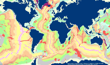
The General Global Map of Seafloor Bedrock Geology (seafloorgeol) shows the global distribution of seafloor bedrock, the boundaries of the continental shelf and continental slope, the axes of the oceanic ridges and other marine geological features. Sedimentary deposits are not shown. The map is based on extracts from Bouysse et al. (2010) © CGMW, and Bryan & Ernst (2008) using Esri Basemap, HERE, Garmin, FAO, NOAA, USGS, © OpenStreetMap contributors and the GIS User Community.
-

INSPIRE View Service for CORINE Land Cover – 5ha. This service provides from CORINE Land Cover 5ha (CLC5) transformed datasets for the INSPIRE theme Land Cover. The data provided through this service covers the area of Germany.
-

Dieser Dienst stellt die Blattschnitteinteilung sowie -nummerierung der Topographischen Kartenwerke 1:25000, 1:50000 sowie 1:100000 in je einer Ebene dar. Die Blattschnitte beziehen sich dabei auf das Printprodukt der Topographische Karte, nicht auf die Rasterdaten der Digitalen Topographischen Karte.
-
INSPIRE View Service for CORINE Land Cover – 5ha. This service provides from CORINE Land Cover 5ha (CLC5) transformed datasets for the INSPIRE theme Land Cover. The data provided through this service covers the area of Germany. Maßstab: 1:250000; Bodenauflösung: 500m; Scanauflösung (DPI): null