 My GeoNetwork catalogue
seismics
Provided by
Type of resources
Available actions
Topics
Keywords
Contact for the resource
Service types
-
On the MS Explora (1st September, 1976 - 29th September, 1976) multichannel seismic measurements were carried out on 44 lines The area covered was the Barentssea. The data format is Society of Exploration Geophysicists SEG Y.
-
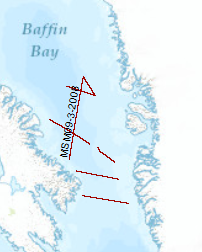
The cruise leg MSM09/3 was conducted as a cooperative project between the Alfred Wegener Institute for Polar and Marine Research (AWI), the Federal Institute for Geosciences and Resources (BGR), the Geological Survey of Denmark and Greenland (GEUS) and Dalhousie University. The data format is Society of Exploration Geophysicists SEG Y. A geophysical survey covered areas of Baffin Bay and Davis Strait between Greenland and the Canadian Baffin Island. A component of the IPY 2007/08 Lead Project Plate Tectonics and Polar Gateways in the Earth System (PLATES & GATES), this project DAVIS GATE is aimed to develop a tectonic and sedimentary reconstruction of the opening process of this oceanic gateway. Baffin Bay and Davis Strait play an important role in the shallow water exchange from the Arctic to the Atlantic Ocean. The plate-tectonic evolution as well as the magmatic history of this region has been sparsely known and required a careful geophysical investigation in order to construct a set of gridded detailed paleotopographic maps for a complete geodynamic reconstruction of this gateway. With a set of three seismic refraction/wide-angle reflection profiles, using ocean-bottom seismometers on 62 stations, as well as multi-channel reflection seismic recordings with a 3000-m long streamer, data were acquired from the sedimentary cover to the deep crust and even from parts of the uppermost mantle. Additional seismic data supplement these profiles and provide insights into the structures of the basement and dominant fault zones such as the Ungava fault system. A parallel running magnetic survey aimed to resolve the temporal evolution of the oceanic crust of Baffin Bay. The extension and subsidence of the continental and transitional crust in the Davis Strait and the evolution of oceanic crust in the Labrador Sea and Baffin Bay could be investigated with dataset to which continuously recorded gravity anomaly data and sub-bottom profiler data also contribute. This dataset provides the basis of geometrical and physical properties of the crust required for a realistic geodynamic model which will describe the break-up and the ocean basin evolution between Greenland and Canada in terms of detailed paleo-topography.
-
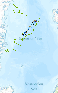
In July/August 1988 a seismic reconnaisance survey was carried out with F.S. Polarstern on the perennially ice covered East Greenland shelf between latitudes 73°N and 81°N. The data format is Society of Exploration Geophysicists SEG Y. 14 reflection seismic lines with a total length of 2.016 km and 12 sonobuoy refraction profiles were recorded. The following results were obtained: •On the wide Holm Land shelf province north of 79°N three possible Cretaceous rift basins were observed. •A buildup of layered extrusive basaltic rocks forming a wedge of seaward dipping reflectors underlies the Holm Land continental slope. •On the Northeastern Greenland shelf province the existence of a wide sedimentary basin was demonstrated north of 76°N. •South of 76°N four volcanic structures from the continent to ocean were observed: The zone of Early Tertiary plateau basalts (zone I) that occur landward of an escarpment, a flat lying basaltic flow unit immediately seaward of the escarpment (zone II), an elongate wedge of seaward dipping reflectors (zone IIIa), a basaltic flow unit which in places shows seaward dipping beds of short length (zone IIIb), and the oceanic crust. •Dyke swarms and intrusions of inferred Neogene age were recognized at several locations.
-
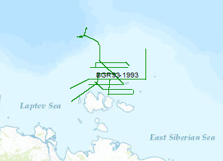
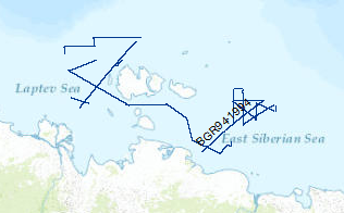
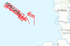
In September 1993, the Federal Institute for Geoscience and Natural Resources (BGR) has carried out in cooperation with Sevmorneftegeofizika (SMNG), Murmansk a 2D-seismic survey of the eastern part of the Laptev Sea shelf. The data format is Society of Exploration Geophysicists SEG Y. During the survey with a total length of 3189 km the 70 km wide New Siberian Basin and two other basins were mapped. In the central part of the New Siberian Basin, a Tertiary sediment thickness of more than 4 km overlying older sediments was observed. Further to the east, a large area covered by lava flows of unknown thickness was investigated. There are no indications of a propagation of real seafloor spreading into the Laptev Shelf and thus the Asian continental crust. Therefore seafloor spreading seems impossible at total spreading rates below 0.7 cm/year, at least for crust of the character which is present here.
-
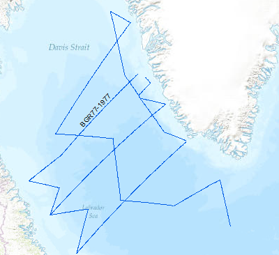
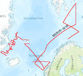
A geophysical reconnaissance survey was carried out in the Labrador Sea and Davis Strait between July and September 1977 by BGR. The data format is Society of Exploration Geophysicists SEG Y. The survey was executed on the research vessel MS Explora. The seismic, magnetic and gravity data from 5931 line-kilometers on 21 lines were recorded on magnetic tape. A 24-fold coverage technique was used with 48 seismic channels (traces), with a 2400m streamer cable, and 23.45 l airgun array. A full integrated computerized satellite navigation system (INDAS III) served as positioning system. Based on a preliminary interpretation of the seismograms, the Labrador Sea was devided into an eastern (Greenland) and western (Canadian) area, seperated by the Mid Labrador Ridge. Within the eastern part of the Labrador Sea the Pre-Cenozoic sediments show three distinct layers, traceable over the entire Greenland area of the sea. In the Cenozoic layer olisthostromes occur. The highest apparent velocity determined from sonobuoy data was 9.26 km/sec. The calculated refractor lies at a depth of approximately 13 km. The seismic section from the sediments on the Canadian side of the Labrador Sea show a uniform series of thick sediments below the Cenozoic cover. The highly disturbed basement is often masked by the multiple reflections from the seafloor. Statements about the nature and structure of the basement can only be made after processing data.
-
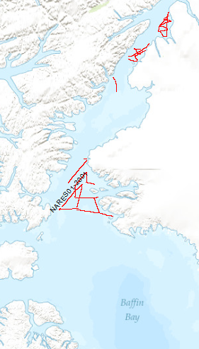
The Scientific staff and crew onboard CCGS Louis S. St. Laurent (LSL) returned September the 10th, 2001 from a scientific expedition to the Nares Strait, the northernmost waterway connecting the Arctic and Atlantic oceans. The data format is Society of Exploration Geophysicists SEG Y. The ice conditions in the strait required the support of Canada's largest ice breaker. The ship was a versatile platform for 34 scientists to accomplish their marine investigation. The LSL has a history of supporting international scientific expeditions including an oceanographic transect of the Arctic Ocean in 1994 and a biological study of the Canadian Arctic Islands in 1999. Germany (Bundesanstalt für Geowissenschaften und Rohstoffe, BGR) and Canada (Geological Survey of Canada) undertook a 5-week scientific cruise to study and explore the geological structure and evolution of the Nares Strait. The primary objective was the study of structural features relating to the formation of the Arctic Ocean and, in particular, the study of the Wegener Fault. This fault is a linear boundary between Greenland and Ellesmere Island which was noted by the German scientist Alfred Wegener in 1915 and later became the subject of a major scientific controversy. The co-operative cruise, which was planned over a period of 2 years, provided the basis for a wide range of scientific investigations, from marine seismic work and climate change studies through airborne magnetic investigations to geodetic survey measurements and geological sampling onshore. Systematic geophysical offshore studies in this key area had not been undertaken before. Where towing of seismic equipment was not possible because of ice coverage, magnetic maps were made using a helicopter-borne magnetic sensor system. Sediment and water samples taken during the cruise provide information on changes in climate and sea ice cover from the last ice-age to the present. An 11 m-long sediment core from outer Jones Sound is the longest core ever taken in the Canadian Arctic channels and holds clues to the detailed climate history of northern Baffin Bay.
-
On the M/V Akademic Nemchinow multichannel seismic measurements were carried out on 34 lines with a total length of 4,000 km. The area covered was the Laptev Sea. The data format is Society of Exploration Geophysicists SEG Y.
-
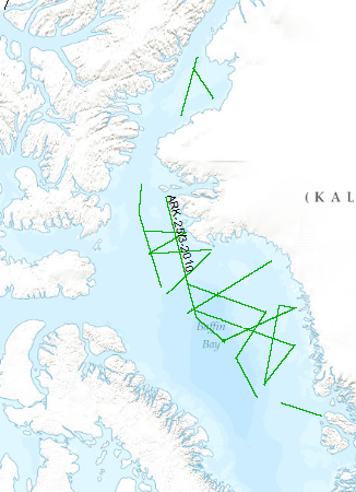
The multidisciplinary marine geoscientific expedition ARK-25/3 was focused on the Greenland part of northern Baffin Bay and was aimed to acquire new geoscientific data to be used for modelling the evolution of the Greenland continental margin and its hydrocarbon prospective. The data format is Society of Exploration Geophysicists SEG Y. The cruise was performed under the direction of the Federal Institute for Geosciences and Natural Resources Hannover in cooperation with the Alfred-Wegener-Institute for Polar and Marine Research, Bremerhaven. Using 70 days of ship time onboard the research icebreaker R/V POLARSTERN a comprehensive data set was acquired along profiles extending from the deep oceanic basin in the central part of North Baffin Bay onto the Greenland continental margin in an area which was bordered by the Kane Basin in the North and Disko Island in the South. By means of multi-channel seismic, wide angle seismic, gravimetric and magnetic methods the structural inventory of the crust in the NW Baffin Bay was investigated. Additionally, heat flow data and sediment cores were collected along lines crossing the Greenland continental margin. The cores were extracted for geochemical and geomicrobiological analysis to be used for basin modelling, studying the hydrocarbon potential, and the hydrocarbon degradation by microorganisms under polar conditions. Geological sampling in the coastal area was done between Melville Bay and Washington Land. The collected rock material will be used to derive constraints on the erosion history of the coastal area. Aeromagnetic data was acquired covering a substantial part of the marine survey area to investigate magnetic signatures of the oceanic crust and the continental margin. This report summarizes the working programme and contains the documentation of acquired data and first results of the expedition.
-
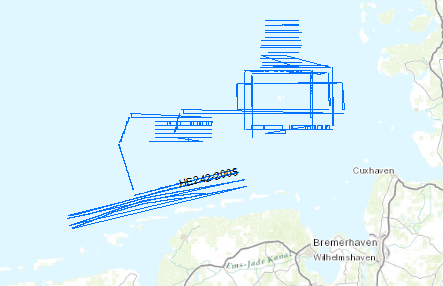
The previous BGR-cruises with RV AURELIA in 2003 and 2004 were designed to collect a grid of seismic MCS-data which should enable us to get a high-resolution overview over the upper 1 s TWT of the sediments of the German North Sea sector. The data format is Society of Exploration Geophysicists SEG Y. Together with the previously acquired data these new data should help to extend our knowledge of the Late Tertiary and Quaternary evolution of the German North Sea Sector. For the current measurements under the scope of the DFG-funded project RE2424/1-1 ‚Nordsee’ the research vessel RV HEINCKE was made available by the ‘Senatskommission für Ozeanographie’ of the DFG. During the cruise a total ca. 1400 km of high quality MCS lines were surveyed and simultaneously measured by a sediment echosounder system that enabled additional profiles during transits with speeds > 5 kn. The BGR high-resolution multichannel seismic reflection system consisting of a GI-Gun (0.8 l) and a 300 m streamer with 24 channels and a sediment echosounder type SES 2000 standard by Innomar, Rostock. While the BGR-seismic system was used to observe the shallow subsurface down to 2 s TWT penetration depth, the sediment echosounder with a penetration depth of several meters was primarily intended to identify sampling positions for the deployment of the BGR vibration corer during the succeeding Leg 2. Additionally, the echosounder system enables the relationship to the highest-resolution multichannel seismic measurements of the group of the University of Bremen on FK SENCKENBERG. All seismic records were processed onboard for the quality control and for a first interpretation.
-
The previous BGR-cruises with RV AURELIA in 2003 and 2004 and RV HEINCKE in 2005 and RV ALKOR in 2006 were designed to collect a grid of seismic MCS-data which should enable us to get a high-resolution overview over the upper 1-2 s TWT of the sediments of the German North Sea sector. The data format is Society of Exploration Geophysicists SEG Y. The aim of this cruise was a detailed survey in the north westernmost area of the German EEZ (exclusive economic zone), the so-called ‘Entenschnabel’ and additionally a mapping of special glacial structures off Sylt Island. The cruise was subdivided into two Legs. One outreaching additional aim was to extend the results from the previous cruises for the Late Tertiary and Quaternary sedimentary evolution into the ‘Entenschnabel’-area which was virtually unexplored by systematic shallow high-resolution seismics. During Leg 1 the BGR high-resolution multichannel seismic reflection system consisting of a GI-Gun (0.8 l) and a 500 m streamer with 36 channels and a shallow swath bathymetric system, type SIMRAD EM1200 by Kongsberg, Bergen, Norway were used. While the BGR-seismic system was used to observe the shallow subsurface down to 2 s TWT penetration depth, the swath bathymetric system was used to identify possible pockmark locations as well as sampling positions for the deployment of the BGR vibration corer during the succeeding Leg 2. All seismic records were processed onboard for the quality control and for a first interpretation loaded into GEOQUEST.