 www.geodatenkatalog.de (S3L)
Keyword
groundwater
21 record(s)
Provided by
Type of resources
Available actions
Topics
Keywords
Update frequencies
Service types
-
-
-

-
-
-
-
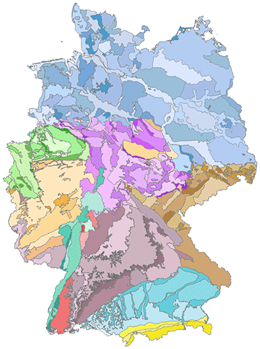
The hydrogeological spatial structure provides a delimitation of areas with very similar hydrogeological characteristics. These areas, with increasing detail, include large hydrogeological regions, hydrogeological regions and hydrogeological subregions. Each higher level is completely made up of one or more units of the next lower level. In order to compile a digital map of large hydrogeological regions, hydrogeological regions and subregions of Germany, existing regional maps and drafts of the State Geological Surveys have been harmonised and brought together. All in all, the territory of Germany has been subdivided in 10 large hydrogeological regions, in 36 hydrogeological regions and 247 hydrogeological subregions.
-
Beschreibung des INSPIRE Download Service (predefined Atom): Roh- und Grundwassermessstellen in Hessen aus dem Fachinformationssystem Grundwasserdatenbank Hessen (Gruwah) 1) Messstellen nach der Rohwasseruntersuchungsverordnung (RUV) und 2) Messstellen des Landesgrundwasserdienstes (LGD) - Der/die Link(s) für das Herunterladen der Datensätze wird/werden dynamisch aus GetFeature Anfragen an einen WFS 1.1.0+ generiert
-
Roh- und Grundwassermessstellen in Hessen aus dem Fachinformationssystem Grundwasserdatenbank Hessen (Gruwah) 1) Messstellen nach der Rohwasseruntersuchungsverordnung (RUV) und 2) Messstellen des Landesgrundwasserdienstes (LGD):Roh- und Grundwassermessstellen in Hessen aus dem Fachinformationssystem Grundwasserdatenbank Hessen (Gruwah) 1) Messstellen nach der Rohwasseruntersuchungsverordnung (RUV) und 2) Messstellen des Landesgrundwasserdienstes (LGD)
-
Beschreibung des INSPIRE Download Service (predefined Atom): Roh- und Grundwassermessstellen in Hessen aus dem Fachinformationssystem Grundwasserdatenbank Hessen (Gruwah) 1) Messstellen nach der Rohwasseruntersuchungsverordnung (RUV) und 2) Messstellen des Landesgrundwasserdienstes (LGD) - Der/die Link(s) für das Herunterladen der Datensätze wird/werden dynamisch aus Download Link aus einem Metadatensatz generiert