 My GeoNetwork catalogue
Natural risk zones
Provided by
Type of resources
Available actions
Topics
Keywords
Contact for the resource
Update frequencies
Service types
-

The product is automatically derived from Sentinel-3 (OLCI) satellite imagery in near-real time. It is an incremental product, meaning that the retrieved results are updated as soon as new input data becomes available over a timespan of ten days. Besides the fire perimeter, and detection time each feature contains information about the severity of the burning.
-

The product is automatically derived from Aqua/Terra (MODIS) satellite imagery in near-real time. It is an incremental product, meaning that the retrieved results are updated as soon as new input data becomes available over a timespan of ten days. Besides the fire perimeter and detection time, each feature contains information about the severity of the burning.
-
This data set represents the monthly, accumulated results of the final (10-day) version of the fire perimeters from the "Burnt Area Daily NRT Incremental Product - Europe, Sentinel-3" dataset. The burn perimeters are spatially and temporally correlated, so that interrelated detections from consecutive observations are combined into a single feature. A perimeter is interpreted as belonging to a given event if a spatial overlap exists within a time frame of 15 days. Besides the geometry, attribute information is also combined while considering the size of the perimeter as a weighting factor. Each feature contains information about the final fire perimeter, Date/Time of the first detection, and the averaged burn severity.
-
This collection contains TerraSAR-X Level 1b data acquired over the pre-defined Geohazard Supersites and a number of CEOS projects regions. The collection comprises mainly complex (SSC) with a number of detected (MGD) products. TerraSAR-X data can be ordered by a Principal Investigator (PI) of a respective Supersite region under the terms of a TerraSAR-X Science proposal accepted by DLR. Data is available for download by the Geohazard scientific community under the terms of the user license. Supersites are single sites or extended areas of high priority to the Geohazards community in which active single or multiple geological hazards pose a threat to human population and/or critical facilities. The Supersites initiative provides access to spaceborne and in-situ geophysical data of selected sites prone to earthquake, volcano or other hazards. For further information see: http://ceos.org/ourwork/workinggroups/disasters/gsnl/ Overview of permament Supersites: http://geo-gsnl.org/supersites/permanent-supersites/
-

The SAR4Tectonics project aims to provide open-access, global measurements of ground deformation in high-strain areas near tectonic plate boundaries. By leveraging the capabilities of the Persistent and Distributed Scatterer (PS/DS) technique with Sentinel-1 SAR images, the project seeks to deliver comprehensive and accurate data on ground deformation, which is crucial for understanding geological processes, assessing seismic risks in these regions, and advance our understanding of Earth's dynamic processes in general. The PS/DS technique offers significantly denser spatial coverage than GNSS, enabling the detection of more localized deformation signals. For the first time, such a vast and detailed dataset is made publicly available. By making this data openly accessible, the SAR4Tectonics project hopes to reduce the burden of SAR data processing for geoscientists, facilitating future studies.The project involved processing 6.5 years of SAR data, focusing on areas where the second invariant of strain exceeds 3 nanostrain per year. Various error corrections were employed, including tropospheric delay correction using ECMWF reanalysis data, ionospheric mitigation via CODE total electron content maps, and solid earth tide modeling. Additionally, the impact of vegetation and soil moisture on distributed scatterers was minimized through a full covariance matrix (phase linking) approach, and the results were calibrated using GNSS data. The final dataset includes line-of-sight average velocity maps, deformation time series, projection vectors, and reference plate modeled velocities.
-

This data set represents the yearly, accumulated results of the final (10-day) version of the fire perimeters from the "Burnt Area Daily NRT Incremental Product - Europe, Sentinel-3" dataset. The burn perimeters are spatially and temporally correlated, so that interrelated detections from consecutive observations are combined into a single feature. A perimeter is interpreted as belonging to a given event if a spatial overlap exists within a time frame of 15 days. Besides the geometry, attribute information is also combined while considering the size of the perimeter as a weighting factor. Each feature contains information about the final fire perimeter, Date/Time of the first detection, and the averaged burn severity
-
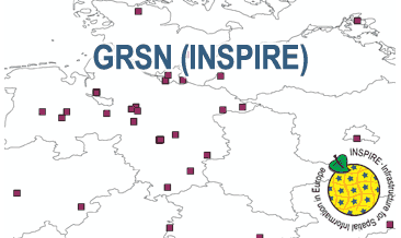
The WMS GRSN (INSPIRE) represents the seismological stations of the German Regional Seismic Network (GRSN) equipped with 3-component broadband seismometer and digital data aquisition system. The recorded data are directly transmitted to the data center at BGR in Hannover and made available to the public near realtime. According to the Data Specification on Geology (D2.8.II.4_v3.0, subtopic Geophysics) the information with respect to the seismological stations is INSPIRE-compliant. The WMS GRSN (INSPIRE) contains a layer of the seismological stations (GE.seismologicalStation) displayed correspondingly to the INSPIRE portrayal rules. Via the getFeatureInfo request the user obtains the content of the INSPIRE attributes platformType, relatedNetwork, stationType und stationRank.
-
Darstellung für Themenstadtplan, tatsächliches Überschwemmungsgebiet der Elbe am 04.04.2006 bei 7,48 m am Pegel Dresden
-
Elbe - 500 cm Pegel Dresden, potentiell überschwemmte Flächen
-
überschwemmte Fläche und Betroffenheiten beim Elbe-Hochwasser September 2024