My GeoNetwork catalogue
soil
Provided by
Type of resources
Available actions
Topics
Keywords
Contact for the resource
Update frequencies
Service types
-
Note: Do not use use this version any more, use version 1.21 instead! doi:10.1594/WDCC/WRF_NOAH_HWSD_world_TOP_ST_v121 Data contain dominating soil type in a grid cell for the whole world at 30 arc-second (~1km) horizontal resolution. The data are based on Harmonized World Soil Database (HWSD), but reclassified according to the State Soil Geographic (STATSGO) classification table of the Weather Research and Forecasting (WRF) Model for NOAH and NOAH-MP Land Surface Models (LSMs). The source of the data is HWSD version 1.2, provided by the Food and Agriculture Organization of the United Nations (FAO), the International Institute for Applied Systems Analysis (IIASA), International Soil Reference and Information Centre (ISRIC), Institute of Soil Science - Chinese Academy of Sciences (ISSCAS) and Joint Research Centre of the European Commission (JRC) in 2012 (FAO/IIASA/ISRIC/ISSCAS/JRC, 2012. Harmonized World Soil Database (version 1.2). FAO, Rome, Italy and IIASA, Laxenburg, Austria). More information on HWSD data available on the web page: http://webarchive.iiasa.ac.at/Research/LUC/External-World-soil-database/HTML/ Horizontal resolution: 0.0083333333333333° Type/units: categorical/1-16 categories Missing_value: 241.0 Projection: regular latitude longitude
-
Data contain dominating soil type in a grid cell for the whole world at 30 arc-second (~1km) horizontal resolution. The data are based on Harmonized World Soil Database (HWSD), but reclassified according to the State Soil Geographic (STATSGO) classification table of the Weather Research and Forecasting (WRF) Model for NOAH and NOAH-MP Land Surface Models (LSMs). The source of the data is HWSD version 1.21, provided by the Food and Agriculture Organization of the United Nations (FAO), the International Institute for Applied Systems Analysis (IIASA), International Soil Reference and Information Centre (ISRIC), Institute of Soil Science - Chinese Academy of Sciences (ISSCAS) and Joint Research Centre of the European Commission (JRC) in 2012 (FAO/IIASA/ISRIC/ISSCAS/JRC, 2012. Harmonized World Soil Database (version 1.21). FAO, Rome, Italy and IIASA, Laxenburg, Austria). Horizontal resolution: 0.0083333333333333° Type/units: categorical/1-16 categories Missing_value: -9999(ascii file), 241.0 (WRF-bin) Projection: regular latitude longitude
-
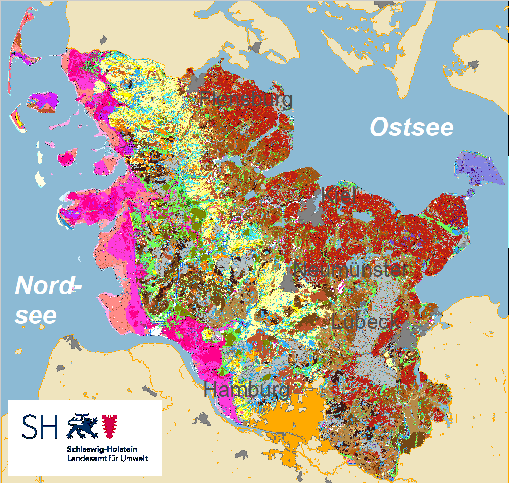
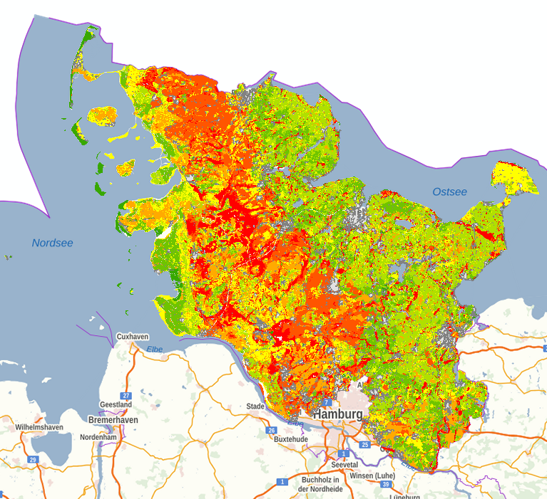
Data contain the dominating soil type in a grid cell for Germany in ~1km horizontal resolution. The data are based on the country wide soil map (Bodenubersichtskarte - BUK) at a scale of 1:1000000 (BUK1000) published in 2007 by Bundesanstalt für Geowissenschaften und Rohstoffe (BGR), Hannover, but reclassified according to the State Soil Geographic (STATSGO) classification table of the Weather Research and Forecasting (WRF) Model for NOAH and NOAH-MP Land Surface Models (LSMs). Horizontal resolution: 0.0083333333333333° Type/units: categorical/1-16 categories Missing_value: 241.0 Projection: regular latitude longitude File format: binary, readable in the WRF Preprocessing System (WPS) Data size:1.2 MB
-
Note: Do not use use this version any more, use version 1.21 instead! doi:10.1594/WDCC/WRF_NOAH_HWSD_world_TOP_ST_v121 Data contain dominating soil type in a grid cell for the whole world at 30 arc-second (~1km) horizontal resolution. The data are based on Harmonized World Soil Database (HWSD), but reclassified according to the State Soil Geographic (STATSGO) classification table of the Weather Research and Forecasting (WRF) Model for NOAH and NOAH-MP Land Surface Models (LSMs). The source of the data is HWSD version 1.2, provided by the Food and Agriculture Organization of the United Nations (FAO), the International Institute for Applied Systems Analysis (IIASA), International Soil Reference and Information Centre (ISRIC), Institute of Soil Science - Chinese Academy of Sciences (ISSCAS) and Joint Research Centre of the European Commission (JRC) in 2012 (FAO/IIASA/ISRIC/ISSCAS/JRC, 2012. Harmonized World Soil Database (version 1.2). FAO, Rome, Italy and IIASA, Laxenburg, Austria). More information on HWSD data available on the web page: http://webarchive.iiasa.ac.at/Research/LUC/External-World-soil-database/HTML/ Horizontal resolution: 0.0083333333333333° Type/units: categorical/1-16 categories Missing_value: 241.0 Projection: regular latitude longitude
-
Data contain dominating soil type in a grid cell for the whole world at 30 arc-second (~1km) horizontal resolution. The data are based on Harmonized World Soil Database (HWSD), but reclassified according to the State Soil Geographic (STATSGO) classification table of the Weather Research and Forecasting (WRF) Model for NOAH and NOAH-MP Land Surface Models (LSMs). The source of the data is HWSD version 1.21, provided by the Food and Agriculture Organization of the United Nations (FAO), the International Institute for Applied Systems Analysis (IIASA), International Soil Reference and Information Centre (ISRIC), Institute of Soil Science - Chinese Academy of Sciences (ISSCAS) and Joint Research Centre of the European Commission (JRC) in 2012 (FAO/IIASA/ISRIC/ISSCAS/JRC, 2012. Harmonized World Soil Database (version 1.21). FAO, Rome, Italy and IIASA, Laxenburg, Austria). Horizontal resolution: 0.0083333333333333° Type/units: categorical/1-16 categories Missing_value: -9999(ascii file), 241.0 (WRF-bin) Projection: regular latitude longitude
-
Data contain the dominating soil type in a grid cell for Germany in ~1km horizontal resolution. The data are based on the country wide soil map (Bodenubersichtskarte - BUK) at a scale of 1:1000000 (BUK1000) published in 2007 by Bundesanstalt für Geowissenschaften und Rohstoffe (BGR), Hannover, but reclassified according to the State Soil Geographic (STATSGO) classification table of the Weather Research and Forecasting (WRF) Model for NOAH and NOAH-MP Land Surface Models (LSMs). Horizontal resolution: 0.0083333333333333° Type/units: categorical/1-16 categories Missing_value: 241.0 Projection: regular latitude longitude File format: binary, readable in the WRF Preprocessing System (WPS) Data size:1.2 MB
-
-
-
-