 My GeoNetwork catalogue
Multispectral
Provided by
Type of resources
Available actions
Topics
Keywords
Contact for the resource
Update frequencies
Service types
-

This vector dataset is based on a 10 m resolution raster dataset that shows forest canopy cover loss (FCCL) in Germany at a monthly resolution from September 2017 to September 2024. Results at pixel level were aggregated at municipality, district, and federal state level. For the results at administrative level we differentiate between deciduous and coniferous forests. We use the stocked area map 2018 (Langner et al. 2022, https://doi.org/10.3220/DATA20221205151218 ) as a reference forest mask. We differentiate between deciduous and coniferous forests by intersecting the stocked area map with a tree species map (Blickensdoerfer et al. 2024). Pixels of the classes birch, beech, oak, alder, deciduous trees with long lifespan and deciduous trees with short lifespan were classified as deciduous forest and pixels of the classes Douglas fir, spruce, pine, larch and fir as coniferous forest. The coverage of the two datasets is not identical, which is why a few areas of the forest reference map remained unclassified. These were filled with the dominant leaf type map of the Copernicus Land Monitoring Service (CLMS 2025). Therefore, the vector data at administrative level contains information about unclassified forest areas and the total forest area as the sum of deciduous, coniferous, and unclassified forests. The FCCL confidence at pixel level is lowest at the end of the time series because the number of repeated threshold exceedance is used as a criterion to record forest canopy cover losses. Therefore, we excluded July 2024 through September 2024 from the annual and overall statistics and summarized the respective FCCL as additional attribute. The dataset is a fully reprocessed continuation of the assessment in Thonfeld et al. (2022).
-

This raster dataset shows forest canopy cover loss (FCCL) in Germany at a monthly resolution from September 2017 to October 2025. It is similar to the product developed by Thonfeld et al. (2022) but was fully reprocessed and updated to reveal the most recent forest disturbance dynamics (Thonfeld et al. 2026). The combination of Sentinel-2A/B and Landsat-8/9 data allows for a high temporal resolution while the pixel size of the product is 10 m. The results are clipped to the stocked area 2018 mapped by the Thünen-Institute (Langner et al. 2022, https://doi.org/10.3220/DATA20221205151218). The dataset contains predominantly larger canopy openings resulting from different drivers but also larger clusters of standing deadwood. FCCL can result from abiotic (e.g. wind, fire, drought, hail) drivers, biotic (e.g. insects, funghi) drivers or a combination of both as well as from sanitary and salvage logging and planned harvest. The first version with canopy cover losses from January 2018 - April 2021 (Thonfeld et al. 2022) can be accessed here: https://geoservice.dlr.de/web/datasets/tccl.
-
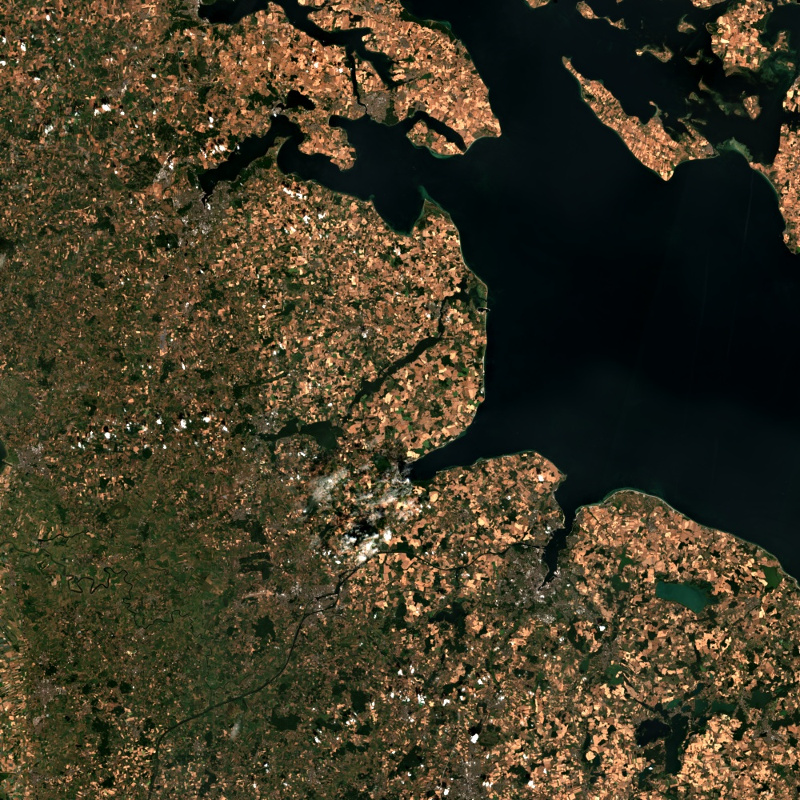
This collection contains Sentinel-2 Level 2A surface reflectances, which are computed for the country of Germany using the time-series based MAJA processor. During the Level 2A processing, the data are corrected for atmospheric effects and clouds and their shadows are detected. The MAJA L2A product is available online for the last 12 months. Further data are kept in the archive and are available upon request. Please see https://logiciels.cnes.fr/en/content/maja for additional information on the MAJA product. The MAJA product offers an alternative to the official ESA L2A product and has been processed with consideration of the characteristics of the Sentinel-2 mission (fast collection of time series, constant sensor perspective, and global coverage). Assumptions about the temporal constancy of the ground cover are taken into account for a robust detection of clouds and a more flexible determination of aerosol properties. As a result, an improved determination of the reflectance of sunlight at the earth's surface (pixel values of the multispectral image) is derived. Further Sentinel-2 Level 2A data computed using MAJA are available on the following website: https://theia.cnes.fr
-

This collection contains synthesized Sentinel-2 Level 3A surface reflectances for Germany on a monthly basis computed by the WASP processor (which utilizes L2A products derived from the MAJA processor). During the Level 3A processing, atmospherically corrected data from a predefined time interval are collected, weighted based on temporal distance and integrated to a new data set with the aim of removing clouds. Thereby, monthly Sentinel-2 Level 3A composites are provided for whole Germany. Please see https://logiciels.cnes.fr/en/content/maja for additional information on the MAJA product. Further Sentinel-2 Level 3A data computed using MAJA are available on the following website: https://theia.cnes.fr
-

This raster dataset shows the main type of crop grown on each field in Germany each year. Crop types and crop rotation are of great economic importance and have a strong influence on the functions of arable land and ecology. Information on the crops grown is therefore important for many environmental and agricultural policy issues. With the help of satellite remote sensing, the crops grown can be recorded uniformly for whole Germany. Based on Sentinel-1 and Sentinel-2 time series as well as LPIS data from some Federal States of Germany, 21 different crops or crop groups were mapped per pixel with 10 m resolution for Germany on an annual basis since 2017. These data sets enable a comparison of arable land use between years and the derivation of crop rotations on individual fields. More details and the underlying methodology can be found in Gessner et al. 2025 and Asam et al. 2022.
-

Dieser Dienst stellt Satellitendaten des Sentinel 2 MSI aus der zweiten Hälfte des Monats April 2017 in unterschiedlichen Kanalkombination und Auflösungen bereit. Pilotdienst im Rahmen von digital@bw.
-

Dieser Dienst stellt Satellitendaten des Sentinel 2 MSI aus der ersten Hälfte des Monats Mai 2017 in unterschiedlichen Kanalkombination und Auflösungen bereit. Pilotdienst im Rahmen von digital@bw.
-

Dieser Dienst stellt Satellitendaten des Sentinel 2 MSI aus der ersten Hälfte des Monats Mai 2018 in unterschiedlichen Kanalkombination und Auflösungen bereit. Pilotdienst im Rahmen von digital@bw.
-

Dieser Dienst stellt Satellitendaten des Sentinel 2 MSI aus der zweiten Hälfte des Monats April 2018 in unterschiedlichen Kanalkombination und Auflösungen bereit. Pilotdienst im Rahmen von digital@bw.
-

Dieser Dienst stellt Satellitendaten des Sentinel 2 MSI aus der zweiten Hälfte des Monats Mai 2017 in unterschiedlichen Kanalkombination und Auflösungen bereit. Pilotdienst im Rahmen von digital@bw.