 My GeoNetwork catalogue
Karst
Provided by
Type of resources
Available actions
Topics
Keywords
Contact for the resource
Update frequencies
Service types
-
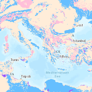
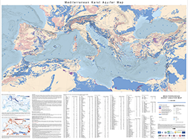
Karst aquifers constitute important freshwater resources, but are challenging to manage and to protect, because of their unique hydraulic structure and behaviour, representing continuous challenges for research and development. Karst aquifers are widespread and contribute to freshwater supply of most Mediterranean countries and many cities are supplied by karst water, e.g., Rome, Vienna, Montpellier and Beirut. These land surfaces correspond to the main recharge zones of karst aquifers, which are often hydraulically connected over large areas and are highly vulnerable to contamination. The preparation of the Mediterranean Karst Aquifer Map (MEDKAM) generally followed the workflow used for the World Karst Aquifer Map (WOKAM). A new lithological classification has been developed for the MEDKAM, similar to that of the WOKAM, which groups the geological units into four meaningful hydrogeological units: 1). Karst aquifers in sedimentary and metamorphic carbonate rocks. 2). Karst aquifers in evaporite rocks. 3). Various hydrogeological settings in other sedimentary and volcanic formations (karst aquifers are possibly present at depth). 4). Local, poor and shallow aquifers in other metamorphic rocks and igneous rocks (no karst aquifers present at depth).
-
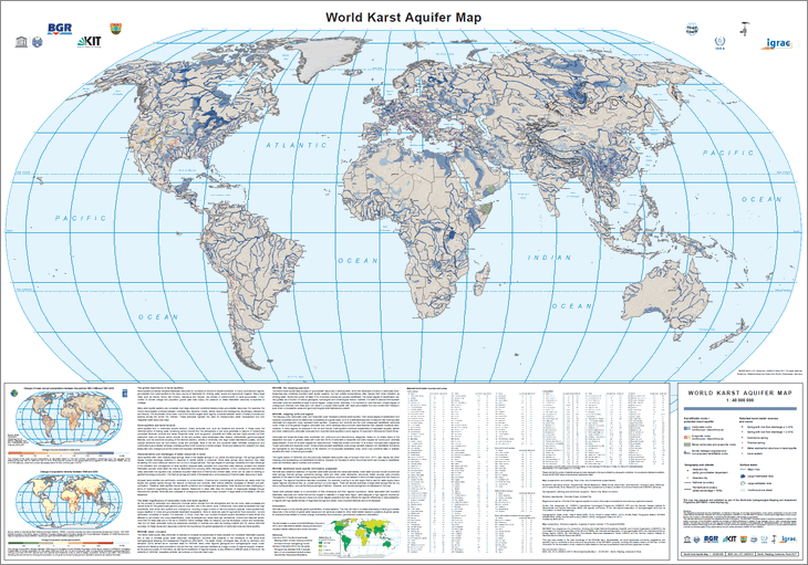
The World-wide Hydrogeological Mapping and Assessment Programme (WHYMAP) provides data and information about the earth´s major groundwater resources. The World Karst Aquifer Map (WOKAM) allows a more precise global quantification of karst systems. The map will help to increase awareness of karst groundwater resources in the context of global water issues and will serve as a basis for other karst-related research questions at global scales: for example those related to climate change, biodiversity, food production, geochemical cycles and urbanisation.
-
Dargestellt ist die Art der Hohlräume in den an der Erdoberfläche verbreiteten hydrogeologischen Einheiten, die für die Speicherung und Bewegung des Grundwassers maßgeblich ist sowie deren Grad der Verfestigung. Über die Attributabfrage können zusätzliche Informationen abgerufen werden.
-
Dieser INSPIRE-Downloaddienst stellt Daten geologisch bedingter Gefährdungspotenziale des Untergrundes in Nordrhein-Westfalen bereit (GDU-Bürgerversion). Aus datenschutzrechtlichen Gründen werden die Informationen nicht grundstücksbezogen, sondern mithilfe von schematisch angeordneten Symbolen, anonymisiert in jeweils 0,5 x 0,5 Kilometer großen Rasterflächen dargestellt. Der Datensatz ist für das INSPIRE-Thema Natural Risk Zones aufbereitet und enthält zusätzlich die Raster-Planquadrate.
-
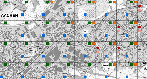
Das Onlineportal "Gefährdungspotenziale des Untergrundes in Nordrhein-Westfalen" (GDU-Bürgerversion) informiert über geologisch oder bergbaulich bedingte Gefährdungspotenziale des Untergrundes in NRW. Aus datenschutzrechtlichen Gründen werden die Informationen nicht grundstücksbezogen, sondern mithilfe von schematisch angeordneten Symbolen, anonymisiert in jeweils 0,5 x 0,5 Kilometer großen Rasterflächen dargestellt. Der Datensatz ist für das INSPIRE-Thema Natural Risk Zones aufbereitet und beinhaltet dementsprechend lediglich die geogen bedingten Gefährdungspotenziale.
-
Dieser Dienst stellt geologisch bedingte Gefährdungspotenziale des Untergrundes in Nordrhein-Westfalen dar (GDU-Bürgerversion). Aus datenschutzrechtlichen Gründen werden die Informationen nicht grundstücksbezogen, sondern mithilfe von schematisch angeordneten Symbolen, anonymisiert in jeweils 0,5 x 0,5 km großen Rasterflächen dargestellt. Der Datensatz ist für das INSPIRE-Thema Natural Risk Zones aufbereitet und enthält zusätzlich die Raster-Planquadrate.
-
Diese digitale Karte stellt die Verbreitung auslaugungsfähiger Gesteine in Sachsen dar. Bearbeitungsstand: 2017.
-
Die Karte liefert eine Bewertung der hydrogeologischen Standortbedingungen für die Installation von Erdwärmebohrungen. Aussage gilt bis maximal 100 m Tiefe.