 My GeoNetwork catalogue
Seismologie
Provided by
Type of resources
Available actions
Topics
Keywords
Contact for the resource
Update frequencies
Service types
-
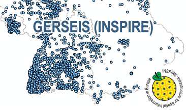
The WMS GERSEIS (INSPIRE) represents the seismological events of the German Earthquake Catalogue which is based on a database providing information on the seismicity in Germany and adjacent areas. It contains locations of seismic events since year 800 where their epicentre determinations are based on historical sources as well as on measurements at seismometer stations since the start of instrumental seismological recording in the 20th century. Today, digital data acquisition at seismometer stations of the German regional seismic network (GRSN), the seismic GERES array, and the Gräfenberg array (GRF) takes place. All events with a local magnitude ML 2.0 and higher are listed. Due to the continuous processing of the seismic events, the INSPIRE dataset is updated annually. The WMS GERSEIS (INSPIRE) contains a layer of the seismological events (NZ.ObservedEvent) displayed correspondingly to the INSPIRE portrayal rules. Via the getFeatureInfo request the user obtains the content of the INSPIRE attributes unitsOfMeasure, qualitativeValue, quantitativeValue, validFrom and intensityScale (short name of citation of the intensity scale).
-
The German Earthquake Catalogue is based on a database providing information on the seismicity in Germany an adjacent areas. It contains locations of seismic events since year 800 where their epicentre determinations are based on historical sources as well as on measurements at seismometer stations since the start of instrumental seismological recording in the 20th century. Today, digital data acquisition at seismometer stations of the German regional seismic network (GRSN), the seismic GERES array, and the Gräfenberg array (GRF) takes place. All events with a local magnitude ML 2.0 and higher are listed. The GML file together with a Readme.txt file are provided in ZIP format (GERSEIS-INSPIRE.zip). The Readme.text file (German/English) contains detailed information on the GML file content. Data transformation was proceeded by using the INSPIRE Solution Pack for FME according to the INSPIRE requirements. Due to the continuous processing of the seismic events, the INSPIRE dataset is updated annually.
-
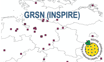
The WMS GRSN (INSPIRE) represents the seismological stations of the German Regional Seismic Network (GRSN) equipped with 3-component broadband seismometer and digital data aquisition system. The recorded data are directly transmitted to the data center at BGR in Hannover and made available to the public near realtime. According to the Data Specification on Geology (D2.8.II.4_v3.0, subtopic Geophysics) the information with respect to the seismological stations is INSPIRE-compliant. The WMS GRSN (INSPIRE) contains a layer of the seismological stations (GE.seismologicalStation) displayed correspondingly to the INSPIRE portrayal rules. Via the getFeatureInfo request the user obtains the content of the INSPIRE attributes platformType, relatedNetwork, stationType und stationRank.
-
The German Regional Seismic Network (GRSN) consists of seismological stations equipped with 3-component broadband seismometer and digital data aquisition system. The recorded data are directly transmitted to the data center at BGR Hannover and made available to the public near realtime. The GML file together with a Readme.txt file are provided in ZIP format (GRSN-INSPIRE.zip). The Readme.text file (German/English) contains detailed information on the GML file content. Data transformation was proceeded by using the INSPIRE Solution Pack for FME according to the INSPIRE requirements.
-
Der Geologische Dienst NRW (GD NRW) betreibt in Nordrhein-Westfalen folgende seismologische Stationen: Xanten, Wassenberg, Jackerath, Pulheim, Hespertal, Aachen, Großhau, Oleftalsperre, Wahnbachtalsperre und Todenfeld. Vom GD NRW mitbetreut werden die Stationen Sorpetalsperre (Ruhrverband), Ennepetalsperre (Ruhrverband) und Urfttalsperre (Wasserverband Eifel-Rur) sowie die in Rheinland-Pfalz befindlichen Stationen Schloss Bürresheim und Wallersheim-Loch. Das Stationsnetz erfasst rund um die Uhr die Erdbebenaktivität der Niederrheinischen Bucht und Umgebung. Die registrierten Daten werden in die Zentrale nach Krefeld übertragen und detailliert ausgewertet, um Ort und Stärke von Erdbeben zu bestimmen und Rückschlüsse auf die im Untergrund ablaufenden Prozesse zu ziehen.
-
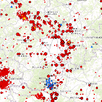
This Web Map Service (WMS) is based on a database providing information on the seismicity in Germany an adjacent areas. It contains locations of seismic events since 800; whereat their epicentre determinations are based on historical sources as well as on measurements of seismometer stations since the start of instrumental seismological recording in the 20th century. Today, digital data acquisition at seismometer stations of the German regional seismic network (GRSN), the seismic GERES array, and the Gräfenberg array (GRF),enables along with near real time data transmission of recorded seismometer data to the seismological central observatory at BGR, the immediate detection and analysis of seismic events, and their provision to the WMS. All events with a local magnitude ML 2.0 and higher are shown. The epicentre determination is initially carried out by an automatic processing procedure. Such a procedure might result - occasionally - inerroneous epicentre estimates and overestimated magnitudes. Therefore results obtained by the automatic procedure routinely post-processed by a manual and inter-active analysis on the following labour day.
-

Der INSPIRE konforme Downloaddienst enthält Informationen zu den Erdbeben aus dem Erdbebenkatalog Baden-Württemberg, erstellt vom Landeserdbebendienst (LED), sowie die Erdbebenmessstationen in und um Baden-Württemberg als Punktgeometrien. Der WFS ermöglicht den Daten-Download der drei Objektklassen Epizentren aktuell, Epizentren historisch und Messstellen in verschiedenen Formaten. Das LGRB betreibt den LED, der die folgenden Aufgaben erfüllt: Erdbebenmessung, Bereitstellung von Erdbebeninformationen und seismischen Messdaten, Erfassung von Wahrnehmungen und Schäden bei Erdbeben und Fachberatung in seismologischen Fragen. Kurzerläuterung des Erdbebenkatalogs unter: https://media.lgrb-bw.de/link/led/readme_led.pdf, Weitere Informationen: https://www.lgrb-bw.de/geologischer-dienst/erdbeben
-
Der Erdbebenkatalog Sachsen-Anhalt enthält die seismologischen Ereignisse, deren Epizentrum im Land lokalisiert wurde, mit Informationen zur zeitlichen und räumlichen Einordnung des Ereignisses sowie Angaben zur Lokalmagnitude bzw. Intensität für ältere Ereignisse und den Herdmechanismus.
-
Der Datensatz umfasst die Standorte der seismologischen Stationen, die vom Landeserdbebendienst NRW (Geologischer Dienst NRW) überwacht werden. Ein Netz von 16 Messstationen erfasst die Erdbebenaktivität der Niederrheinischen Bucht und Umgebung.
-
Die Online-Karte Erdbebenereignisse stellt die vom Landeserdbebendienst Rheinland-Pfalz (LER) registrierten Erdbeben seit dem Jahr 2000 dar. Wie in der Beschreibung des <a href='https://www.lgb-rlp.de/fachthemen-des-amtes/landeserdbebendienst-rheinland-pfalz/erdbeben-stationsnetz.html' target='_blank'>Stationsnetzes</a> dargestellt, ist der LER ein lokal ausgerichtetes Messnetz, es werden ausschliesslich Beben im Umfeld von Rheinland-Pfalz dargestellt. Eine tabellarische Auflistung der registrierten Erdbeben finden sie <a href='https://www.lgb-rlp.de/fachthemen-des-amtes/landeserdbebendienst-rheinland-pfalz/erdbebenereignisse-lokal.html?no_cache=1' target='_blank'>hier</a>.:Die Online-Karte Erdbebenereignisse stellt die vom Landeserdbebendienst Rheinland-Pfalz (LER) registrierten Erdbeben seit dem Jahr 2000 dar. Wie in der Beschreibung des <a href='https://www.lgb-rlp.de/fachthemen-des-amtes/landeserdbebendienst-rheinland-pfalz/erdbeben-stationsnetz.html' target='_blank'>Stationsnetzes</a> dargestellt, ist der LER ein lokal ausgerichtetes Messnetz, es werden ausschliesslich Beben im Umfeld von Rheinland-Pfalz dargestellt. Eine tabellarische Auflistung der registrierten Erdbeben finden sie <a href='https://www.lgb-rlp.de/fachthemen-des-amtes/landeserdbebendienst-rheinland-pfalz/erdbebenereignisse-lokal.html?no_cache=1' target='_blank'>hier</a>.