 My GeoNetwork catalogue
Tektonik
Provided by
Type of resources
Available actions
Topics
Keywords
Contact for the resource
Update frequencies
Service types
-
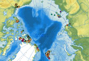
The web service of the dataset comprises the locations of outcrops with respective information on the lithology, stratigraphy, rock age and tectonic data collected during the CASE expeditions. The data attributes include stereographic projections and sketches of tectonic structures derived from the outcrop data. At the end of the 1980s, BGR initiated the research program Circum-Arctic Structural Events (CASE) to reconstruct the plate tectonic processes during the evolution of the Arctic Ocean using terrestrial data from the surrounding continental margins. One of the scientific questions of the CASE programme is as simple as it is complex: How did the Arctic Ocean, this large basin between the Eurasian and North American continental plates, develop? There are still no conclusive answers to this question in terms of plate tectonics. In contrast to the marine expeditions of geophysicists in the Arctic Ocean, geologists on land along the various coastal areas of the Arctic Ocean can directly touch, examine and map rocks, structures, folds and fault zones and determine the respective ages of the movements. This makes it possible to directly compare rock units and deformation zones on different continental plates and thus also to reconstruct when these plates collided, how long they remained next to each other and when and how they separated again. Since the inception of BGR’s Arctic research, the primary focus and research areas have been along the continental margins between Spitsbergen and the Canadian Arctic Archipelago via Greenland, to the Yukon North Slope on the border with Alaska. On the opposite side of the Arctic Ocean, there have been expeditions to Yakutia, the mainland areas near the Laptev Sea, the New Siberian Islands and to the Polar Ural with Russian partners. An important method for the interpretation of the geological evolution of the Arctic is the examination of tectonic structures (faults, folds, cleavage etc.), the determination of the kinematics and the age of the tectonic movements.
-
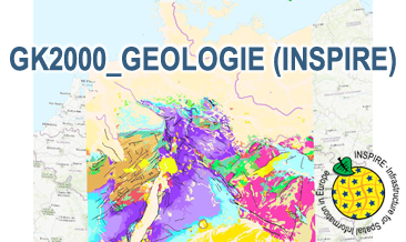
The WMS GK2000 Geologie (INSPIRE) represents the surface geology of Germany and adjacent areas on a scale of 1:2,000,000. According to the Data Specification on Geology (D2.8.II.4_v3.0) the geological map provides INSPIRE-compliant data. The WMS GK2000 Geologie (INSPIRE) contains layers of the geologic units (GE.GeologicUnit), faults (GE.GeologicFault) and marginal position of the ice shield as well as the impact craters Nördlinger Ries and Steinheimer Becken (GE. GeomorphologicFeature) displayed correspondingly to the INSPIRE portrayal rules. The geologic units are represented graphically by stratigraphy (GE.GeologicUnit.AgeOfRocks) and lithology (GE.GeologicUnit.Lithology). For different geochronologic minimum and maximum ages, Upper Devonian - Permian, the portrayal is defined by the colour of the geochronologic minimum age (olderNamedAge). In case of the geologic units the user obtains detailed information via the getFeatureInfo request on the lithology, stratigraphy (age) and genesis (event environment and event process).
-
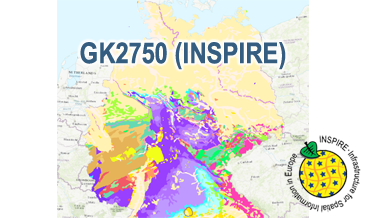
The WMS GK2750 Geology (INSPIRE) represents the surface geology of Germany on a scale of 1:2,750,000. According to the Data Specification on Geology (D2.8.II.4_v3.0) the geological map provides INSPIRE-compliant data. The WMS GK2750 Geology (INSPIRE) contains layers of the geologic units (GE.GeologicUnit), faults (GE.GeologicFault) and marginal position of the ice shield and the impact crater Nördlinger Ries (GE. GeomorphologicFeature) displayed correspondingly to the INSPIRE portrayal rules. The geologic units are represented graphically by stratigraphy (GE.GeologicUnit.AgeOfRocks) and lithology (GE.GeologicUnit.Lithology). For different geochronologic minimum and maximum ages, e.g. Upper Devonian - Permian, the portrayal is defined by the colour of the geochronologic minimum age (olderNamedAge). In case of the geologic units the user obtains detailed information via the getFeatureInfo request on the lithology, stratigraphy (age) and genesis (event environment and event process).
-
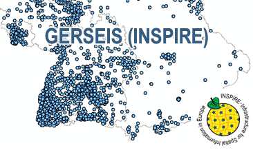
The German Earthquake Catalogue is based on a database providing information on the seismicity in Germany an adjacent areas. It contains locations of seismic events since year 800 where their epicentre determinations are based on historical sources as well as on measurements at seismometer stations since the start of instrumental seismological recording in the 20th century. Today, digital data acquisition at seismometer stations of the German regional seismic network (GRSN), the seismic GERES array, and the Gräfenberg array (GRF) takes place. All events with a local magnitude ML 2.0 and higher are listed. The GML file together with a Readme.txt file are provided in ZIP format (GERSEIS-INSPIRE.zip). The Readme.text file (German/English) contains detailed information on the GML file content. Data transformation was proceeded by using the INSPIRE Solution Pack for FME according to the INSPIRE requirements. Due to the continuous processing of the seismic events, the INSPIRE dataset is updated annually.
-
The WMS GERSEIS (INSPIRE) represents the seismological events of the German Earthquake Catalogue which is based on a database providing information on the seismicity in Germany and adjacent areas. It contains locations of seismic events since year 800 where their epicentre determinations are based on historical sources as well as on measurements at seismometer stations since the start of instrumental seismological recording in the 20th century. Today, digital data acquisition at seismometer stations of the German regional seismic network (GRSN), the seismic GERES array, and the Gräfenberg array (GRF) takes place. All events with a local magnitude ML 2.0 and higher are listed. Due to the continuous processing of the seismic events, the INSPIRE dataset is updated annually. The WMS GERSEIS (INSPIRE) contains a layer of the seismological events (NZ.ObservedEvent) displayed correspondingly to the INSPIRE portrayal rules. Via the getFeatureInfo request the user obtains the content of the INSPIRE attributes unitsOfMeasure, qualitativeValue, quantitativeValue, validFrom and intensityScale (short name of citation of the intensity scale).
-
The dataset comprises the locations of outcrops with respective information on the lithology, stratigraphy, rock age and tectonic data collected during the CASE expeditions. The data attributes include stereographic projections and sketches of tectonic structures derived from the outcrop data. At the end of the 1980s, BGR initiated the research program Circum-Arctic Structural Events (CASE) to reconstruct the plate tectonic processes during the evolution of the Arctic Ocean using terrestrial data from the surrounding continental margins. One of the scientific questions of the CASE programme is as simple as it is complex: How did the Arctic Ocean, this large basin between the Eurasian and North American continental plates, develop? There are still no conclusive answers to this question in terms of plate tectonics. In contrast to the marine expeditions of geophysicists in the Arctic Ocean, geologists on land along the various coastal areas of the Arctic Ocean can directly touch, examine and map rocks, structures, folds and fault zones and determine the respective ages of the movements. This makes it possible to directly compare rock units and deformation zones on different continental plates and thus also to reconstruct when these plates collided, how long they remained next to each other and when and how they separated again. Since the inception of BGR’s Arctic research, the primary focus and research areas have been along the continental margins between Spitsbergen and the Canadian Arctic Archipelago via Greenland, to the Yukon North Slope on the border with Alaska. On the opposite side of the Arctic Ocean, there have been expeditions to Yakutia, the mainland areas near the Laptev Sea, the New Siberian Islands and to the Polar Ural with Russian partners. An important method for the interpretation of the geological evolution of the Arctic is the examination of tectonic structures (faults, folds, cleavage etc.), the determination of the kinematics and the age of the tectonic movements.
-
.png)
The WMS GK1000 (INSPIRE) represents the surface geology of Germany and adjacent areas on a scale of 1:1,000,000. According to the Data Specification on Geology (D2.8.II.4_v3.0) the geological map provides INSPIRE-compliant data. The WMS GK1000 (INSPIRE) contains layers of the geologic units (GE.GeologicUnit), faults (GE.GeologicFault) and marginal position of the ice shield (GE. NaturalGeomorphologicFeature) displayed correspondingly to the INSPIRE portrayal rules. The geologic units are represented graphically by stratigraphy (GE.GeologicUnit.AgeOfRocks) and lithology (GE.GeologicUnit.Lithology). For different geochronologic minimum and maximum ages, e.g. Carboniferous - Permian, the portrayal is defined by the color of the geochronologic minimum age (olderNamedAge). The portrayal of the lithology is defined by the rock or rock group representing the main part of the lithological composition of the geologic unit. In case of the geologic units the user obtains detailed information via the getFeatureInfo request on the lithology, stratigraphy (age) and genesis (event environment and event process).
-
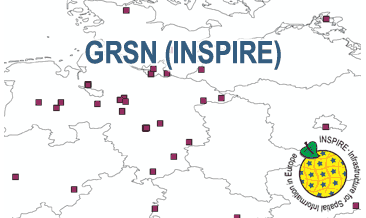
The WMS GRSN (INSPIRE) represents the seismological stations of the German Regional Seismic Network (GRSN) equipped with 3-component broadband seismometer and digital data aquisition system. The recorded data are directly transmitted to the data center at BGR in Hannover and made available to the public near realtime. According to the Data Specification on Geology (D2.8.II.4_v3.0, subtopic Geophysics) the information with respect to the seismological stations is INSPIRE-compliant. The WMS GRSN (INSPIRE) contains a layer of the seismological stations (GE.seismologicalStation) displayed correspondingly to the INSPIRE portrayal rules. Via the getFeatureInfo request the user obtains the content of the INSPIRE attributes platformType, relatedNetwork, stationType und stationRank.
-
The GK2000 Geologie (INSPIRE) represents the surface geology of Germany on a scale of 1:2,000,000. According to the Data Specification on Geology (D2.8.II.4_v3.0) the content of the geological map is stored in three INSPIRE-compliant GML files: GK2000_Geology_GeologicUnit.gml contains the geologic units, GK2000_Geology_GeologicStructure.gml comprises the faults and GK2000_Geology_GeomorphologicFeature.gml represents the marginal position of the ice shield as well as the impact craters Nördlinger Ries and Steinheimer Becken. The GML files together with a Readme.txt file are provided in ZIP format (GK2000_Geologie-INSPIRE.zip). The Readme.text file (German/English) contains detailed information on the GML files content. Data transformation was proceeded by using the INSPIRE Solution Pack for FME according to the INSPIRE requirements.
-
The GK1000 (INSPIRE) represents the surface geology of Germany and adjacent areas on a scale of 1:1,000,000. According to the Data Specification on Geology (D2.8.II.4_v3.0) the content of the geological map is stored in three INSPIRE-compliant GML files: GK1000_GeologicUnit.gml contains the geologic units, GK1000_GeologicStructure.gml comprises the faults and GK1000_NaturalGeomorphologicFeature.gml represents the marginal position of the ice shield. The GML files together with a Readme.txt file are provided in ZIP format (GK1000-INSPIRE.zip). The Readme.text file (German/English) contains detailed information on the GML files content. Data transformation was proceeded by using the INSPIRE Solution Pack for FME according to the INSPIRE requirements.