 My GeoNetwork catalogue
Erdbeben
Provided by
Type of resources
Available actions
Topics
Keywords
Contact for the resource
Update frequencies
Service types
-
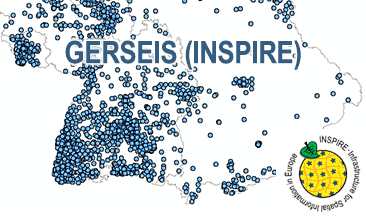
The WMS GERSEIS (INSPIRE) represents the seismological events of the German Earthquake Catalogue which is based on a database providing information on the seismicity in Germany and adjacent areas. It contains locations of seismic events since year 800 where their epicentre determinations are based on historical sources as well as on measurements at seismometer stations since the start of instrumental seismological recording in the 20th century. Today, digital data acquisition at seismometer stations of the German regional seismic network (GRSN), the seismic GERES array, and the Gräfenberg array (GRF) takes place. All events with a local magnitude ML 2.0 and higher are listed. Due to the continuous processing of the seismic events, the INSPIRE dataset is updated annually. The WMS GERSEIS (INSPIRE) contains a layer of the seismological events (NZ.ObservedEvent) displayed correspondingly to the INSPIRE portrayal rules. Via the getFeatureInfo request the user obtains the content of the INSPIRE attributes unitsOfMeasure, qualitativeValue, quantitativeValue, validFrom and intensityScale (short name of citation of the intensity scale).
-
The German Earthquake Catalogue is based on a database providing information on the seismicity in Germany an adjacent areas. It contains locations of seismic events since year 800 where their epicentre determinations are based on historical sources as well as on measurements at seismometer stations since the start of instrumental seismological recording in the 20th century. Today, digital data acquisition at seismometer stations of the German regional seismic network (GRSN), the seismic GERES array, and the Gräfenberg array (GRF) takes place. All events with a local magnitude ML 2.0 and higher are listed. The GML file together with a Readme.txt file are provided in ZIP format (GERSEIS-INSPIRE.zip). The Readme.text file (German/English) contains detailed information on the GML file content. Data transformation was proceeded by using the INSPIRE Solution Pack for FME according to the INSPIRE requirements. Due to the continuous processing of the seismic events, the INSPIRE dataset is updated annually.
-
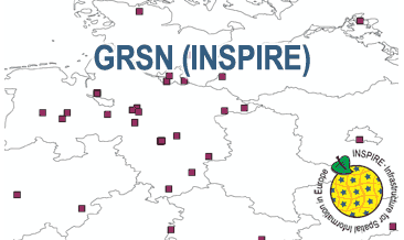
The WMS GRSN (INSPIRE) represents the seismological stations of the German Regional Seismic Network (GRSN) equipped with 3-component broadband seismometer and digital data aquisition system. The recorded data are directly transmitted to the data center at BGR in Hannover and made available to the public near realtime. According to the Data Specification on Geology (D2.8.II.4_v3.0, subtopic Geophysics) the information with respect to the seismological stations is INSPIRE-compliant. The WMS GRSN (INSPIRE) contains a layer of the seismological stations (GE.seismologicalStation) displayed correspondingly to the INSPIRE portrayal rules. Via the getFeatureInfo request the user obtains the content of the INSPIRE attributes platformType, relatedNetwork, stationType und stationRank.
-
Sammlung von Informationen über Georisiken in Hamburg, wie Erdfälle, Hangrutschungen usw.
-
The German Regional Seismic Network (GRSN) consists of seismological stations equipped with 3-component broadband seismometer and digital data aquisition system. The recorded data are directly transmitted to the data center at BGR Hannover and made available to the public near realtime. The GML file together with a Readme.txt file are provided in ZIP format (GRSN-INSPIRE.zip). The Readme.text file (German/English) contains detailed information on the GML file content. Data transformation was proceeded by using the INSPIRE Solution Pack for FME according to the INSPIRE requirements.
-
Beschreibung der bekannten Erdbeben in Hamburg.
-
Lage der Erdbebenmessstationen im Landkreis Diepholz
-
Der Geologische Dienst NRW (GD NRW) betreibt in Nordrhein-Westfalen folgende seismologische Stationen: Xanten, Wassenberg, Jackerath, Pulheim, Hespertal, Aachen, Großhau, Oleftalsperre, Wahnbachtalsperre und Todenfeld. Vom GD NRW mitbetreut werden die Stationen Sorpetalsperre (Ruhrverband), Ennepetalsperre (Ruhrverband) und Urfttalsperre (Wasserverband Eifel-Rur) sowie die in Rheinland-Pfalz befindlichen Stationen Schloss Bürresheim und Wallersheim-Loch. Das Stationsnetz erfasst rund um die Uhr die Erdbebenaktivität der Niederrheinischen Bucht und Umgebung. Die registrierten Daten werden in die Zentrale nach Krefeld übertragen und detailliert ausgewertet, um Ort und Stärke von Erdbeben zu bestimmen und Rückschlüsse auf die im Untergrund ablaufenden Prozesse zu ziehen.
-
Übersicht der 5km-Radien um die Erdbebenmessstationen im Landkreis Diepholz
-
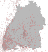
Der Erdbebenkatalog Baden-Württemberg, bearbeitet vom Landeserdbebendienst (LED), beinhaltet Angaben über Erdbeben in und um Baden-Württemberg. Kartenmäßig dargestellt sind natürliche (tektonische) und induzierte Erdbeben im Gebiet 47.3°N bis 50.0°N und 7.2°E bis 10.75°E seit 1994. Ab 1996 ist der Katalog vollständig für Erdbeben stärker als etwa Magnitude ML = 2.0 (Richter-Skala). Mit dem Ausbau des Messnetzes und der gestiegenen Empfindlichkeit kann heute von einer Vollständigkeit mindestens ab Magnitude ML=1.5 im bearbeiteten Gebiet ausgegangen werden. Unter dem Begriff "induzierte Erdbeben" werden nicht-natürliche seismische Ereignisse zusammengefasst. Dazu zählen z. B. Bergschläge, d.h. Erdbeben im Bereich von aktiven oder offen gelassenen Grubengebäuden. Weitere induzierte Erdbeben stehen in Zusammenhang mit der Rohstoffgewinnung aus Bohrungen, also Erdöl-, Erdgas- oder Erdwärmeförderung bzw. Verpressung von Flüssigkeiten oder Gasen in den Untergrund. Steinbruchsprengungen sind im Katalog nicht enthalten. Als "gespürt" werden diejenigen Erdbeben gekennzeichnet, denen eine maximale Intensität (nicht zu verwechseln mit der Magnitude) auf der Europäischen Makroseismischen Skala (EMS-98, früher auch andere Skalen) von mindestens III zugeordnet werden kann. Insbesondere in den frühen Jahren der Zusammenstellung sind auch Erdbeben dargestellt, die von anderen Agenturen als dem LED bearbeitet wurden. Die entsprechende Quelle (verantwortliche Agentur) wird jeweils aufgeführt. Für Epizentren außerhalb des Landesgebiets von Baden-Württemberg und Rheinland-Pfalz sind die Angaben des LED bzw. des EDSW nicht maßgeblich. Die maßgeblichen Angaben veröffentlicht der jeweils lokal zuständige Erdbebendienst.