 My GeoNetwork catalogue
Bodenfruchtbarkeit
Provided by
Type of resources
Available actions
Topics
Keywords
Contact for the resource
Update frequencies
Service types
-

-

-
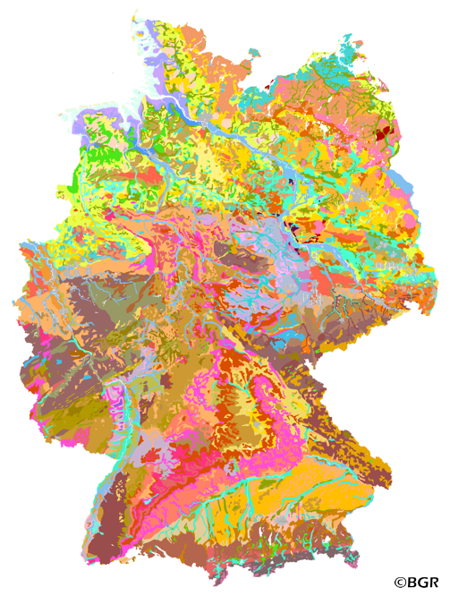
Web Map Service (WMS) of the BUEK1000. The first country wide soil map at a scale of 1:1,000,000 (BUEK1000) has been compiled on the basis of published soil maps of the former German Democratic Republic and the pre 1990 federal states of Germany. To do this, it was necessary to match the soil systems used in East and West Germany and to develop standardized descriptions of soil units. A relatively homogeneous map has resulted, which permits uniform assessment of the soils throughout Germany. The map shows 71 soil mapping units, described in the legend on the basis of the German and FAO soil systems. Each soil unit has been assigned a characteristic soil profile (Leitprofil) as an aid to map interpretation. For the first time the subdivision of the country into 12 soil regions has been represented on the map. This subdivision was coordinated with the state Geological Surveys. These soil regions will represent the highest hierarchic level of nation wide soil maps in future. The colours of soil units correspond to the standards of the 'Bodenkundliche Kartieranleitung' (KA 3; Guidelines for Soil Mapping). The various hues characterize differences in relief or soil humidity. The BUEK1000 was produced digitally. It is an important part of the spatial database integrated in the Soil Information System currently being established at the Federal Institute for Geosciences and Natural Resources (FISBo BGR). It can be used together with the characteristic soil profiles to derive thematic maps related to nation wide soil protection. The scale of the BUEK1000 makes it especially suitable for small scale evaluations at federal or EU level.
-
The first country wide soil map at a scale of 1:1,000,000 (BUEK1000) has been compiled on the basis of published soil maps of the former German Democratic Republic and the pre 1990 federal states of Germany. To do this, it was necessary to match the soil systems used in East and West Germany and to develop standardized descriptions of soil units. A relatively homogeneous map has resulted, which permits uniform assessment of the soils throughout Germany. The map shows 71 soil mapping units, described in the legend on the basis of the German and FAO soil systems. Each soil unit has been assigned a characteristic soil profile (Leitprofil) as an aid to map interpretation. For the first time the subdivision of the country into 12 soil regions has been represented on the map. This subdivision was coordinated with the state Geological Surveys. These soil regions will represent the highest hierarchic level of nation wide soil maps in future. The colours of soil units correspond to the standards of the 'Bodenkundliche Kartieranleitung' (KA 3; Guidelines for Soil Mapping). The various hues characterize differences in relief or soil humidity. The BUEK1000 was produced digitally. It is an important part of the spatial database integrated in the Soil Information System currently being established at the Federal Institute for Geosciences and Natural Resources (FISBo BGR). It can be used together with the characteristic soil profiles to derive thematic maps related to nation wide soil protection. The scale of the BUEK1000 makes it especially suitable for small scale evaluations at federal or EU level.
-

Grundlage der Ableitungen des Kriteriums ist die Bodenfunktionenkarte „Natürliche Bodenfruchtbarkeit“. Aus der Karte wurden die mit der Stufe I (sehr gering) bewerteten Bodenflächen selektiert. Von diesen wurden die Böden mit nassen/feuchten Eigenschaften getrennt. Abgebildet werden terrestrische Böden geringer Bodenmächtigkeit und Böden mit hohen Skeletteinschlüssen bzw. hohen Grobbodenanteilen. Diese Böden haben nur geringe bis sehr geringe Wasserspeichereigenschaften. Im Jahresverlauf fallen diese Böden durch Trockenheit auf. Typische natürliche Pflanzengesellschaften und Bodenorganismen sind an diese Bodenverhältnisse angepasst.
-

Der WFS-Dienst liefert die Bodenfunktionenkarten auf Grundlage der Bodenschätzung im Maßstab 1 : 5.000 aus. Die Informationen zur Erstellung der Bodenfunktionenkarten können dem zugehörigen Datensatz entnommen werden. Der WFS-Dienst stellt sechs Layer zur Verfügung. Dies sind die Layer Natürliche Bodenfruchtbarkeit, besonders feuchte/nasse Böden, besonders trockene Böden, Wasserspeichervermögen und Ausgleichsmedium für stoffliche Einträge. Zusätzlich wurde der Layer Schützenswerte Böden in EEG-Korridoren ergänzt.
-

Andererseits können Grundwasseranstau- bzw. Bewässerungsmaßnahmen zur Vernässung von staunässeempfindlichen und natürlicherweise trockenen, terrestrischen Böden führen. Die Bodenfunktionen sind durch das Fehlen bzw. das Vorhandensein von Grund- und Stauwasser und durch ein sehr geringes Wasserspeichervermögen geprägt. Folglich reagieren natürlicherweise trockene Böden empfindlich auf Vernässung.
-
Die Bodenfunktionenbewertung auf Grundlage der Bodenschätzung erfolgt nach den Maßgaben des Sächsischen Bodenbewertungsinstrumentes (Stand: 05/2022). Die Datenserie umfasst die beiden Datensätze »Bodenfunktionenkarten nach Bodenschätzung im Maßstab 1 : 5.000« und »Bodenempfindlichkeitskarten nach Bodenschätzung im Maßstab 1 : 5.000«. Datengrundlage für die Bewertung sind die digitalen Bodenschätzungsdaten aus dem Amtlichen Liegenschaftskatasterinformationssystem (ALKIS) zum Stand 12/2022.
-
Die Bodenfunktionenkarten wurden nach dem Sächsischen Bodenbewertungsinstrument Stand 05/2022 erstellt. Erstmalig wurden alle für die Bewertung eingesetzten rund 754.000 Bodenschätzungsflächen des Freistaates Sachsen einer bodenfunktionalen Bewertung unterzogen. Die Auswertungen im Maßstab 1 : 5.000 basieren auf den digitalisierten Bodenschätzungsflächen zum Stand 12/2022. Sukzessive werden neue Kenntnisstände zur Bodenschätzung, z.B. durch Nachschätzungen, in die Bewertungen der Bodenfunktionen eingearbeitet. Diese Informationen werden mit Updates veröffentlicht. Die Bodenfunktionenkarten auf Grundlage der Bodenschätzung umfassen fünf Layer. Dies sind: Natürliche Bodenfruchtbarkeit, besonders feuchte/nasse Böden, besonders trockene Böden, Wasserspeichervermögen und Ausgleichsmedium für stoffliche Einträge. Zusätzlich wurden die beiden Layer Schützenswerte Böden in EEG-Korridoren und Korridor Bahn Autobahn EEG nach BauGB ergänzt, um auf besonders schützenswerte Böden mit höchster Bodenfunktionenerfüllung (Stufe V bei natürlicher Bodenfruchtbarkeit und Wasserspeichervermögen) in den Korridoren für die vorrangige Nutzung für Photovoltaikanlagen nach § 35 BauGB hinzuweisen. Damit soll die Inanspruchnahme von Böden für erneuerbare Energien auf Flächen mit geringerer Funktionenerfüllung gelenkt werden.
-

Änderungen des Grundwasserstandes können mit z.T. irreversiblen Schäden für Böden und Ökosysteme verbunden sein. Gegenüber Grundwasserabsenkungen sind besonders solche Böden empfindlich, deren Funktionen von einem hohen Grundwasserstand abhängen, so z.B. Moore, Nass- und Auengleye, sowie grundwasserbeeinflusste Böden, z.B. Gleye und vergleyte Böden. Böden mit nassen und extrem feuchten Eigenschaften werden aus den Bewertungen der Bodenteilfunktion Lebensraum und Lebensgrundlage gefiltert und als Böden mit „Empfindlichkeit bei Trockenlegung“ dargestellt.