Keyword
Bodenkarte
326 record(s)
Provided by
Type of resources
Available actions
Topics
Keywords
Contact for the resource
Update frequencies
Service types
-
-
-

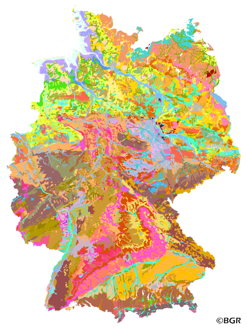
Web Map Service (WMS) of the BUEK1000. The first country wide soil map at a scale of 1:1,000,000 (BUEK1000) has been compiled on the basis of published soil maps of the former German Democratic Republic and the pre 1990 federal states of Germany. To do this, it was necessary to match the soil systems used in East and West Germany and to develop standardized descriptions of soil units. A relatively homogeneous map has resulted, which permits uniform assessment of the soils throughout Germany. The map shows 71 soil mapping units, described in the legend on the basis of the German and FAO soil systems. Each soil unit has been assigned a characteristic soil profile (Leitprofil) as an aid to map interpretation. For the first time the subdivision of the country into 12 soil regions has been represented on the map. This subdivision was coordinated with the state Geological Surveys. These soil regions will represent the highest hierarchic level of nation wide soil maps in future. The colours of soil units correspond to the standards of the 'Bodenkundliche Kartieranleitung' (KA 3; Guidelines for Soil Mapping). The various hues characterize differences in relief or soil humidity. The BUEK1000 was produced digitally. It is an important part of the spatial database integrated in the Soil Information System currently being established at the Federal Institute for Geosciences and Natural Resources (FISBo BGR). It can be used together with the characteristic soil profiles to derive thematic maps related to nation wide soil protection. The scale of the BUEK1000 makes it especially suitable for small scale evaluations at federal or EU level.
-

The first country wide soil map at a scale of 1:1,000,000 (BUEK1000) has been compiled on the basis of published soil maps of the former German Democratic Republic and the pre 1990 federal states of Germany. To do this, it was necessary to match the soil systems used in East and West Germany and to develop standardized descriptions of soil units. A relatively homogeneous map has resulted, which permits uniform assessment of the soils throughout Germany. The map shows 71 soil mapping units, described in the legend on the basis of the German and FAO soil systems. Each soil unit has been assigned a characteristic soil profile (Leitprofil) as an aid to map interpretation. For the first time the subdivision of the country into 12 soil regions has been represented on the map. This subdivision was coordinated with the state Geological Surveys. These soil regions will represent the highest hierarchic level of nation wide soil maps in future. The colours of soil units correspond to the standards of the 'Bodenkundliche Kartieranleitung' (KA 3; Guidelines for Soil Mapping). The various hues characterize differences in relief or soil humidity. The BUEK1000 was produced digitally. It is an important part of the spatial database integrated in the Soil Information System currently being established at the Federal Institute for Geosciences and Natural Resources (FISBo BGR). It can be used together with the characteristic soil profiles to derive thematic maps related to nation wide soil protection. The scale of the BUEK1000 makes it especially suitable for small scale evaluations at federal or EU level.
-
Bodenkarten (Bodeneignungskarte,Bodenkarte,Wasser- und Baugrundkarte)
-
Digitale Bodenkarte des Geologischen Landesamtes (GLA), Krefeld
-

Die Bodenübersichtskarte von Bayern 1:200.000 (BÜK200-BY) entstand durch Zusammenführung der bundesweit in Einzelblattschnitten vorliegenden und über die BGR erhältlichen Bodenübersichtskarte der Bundesrepublik Deutschland (BÜK200). Für den Gesamtumgriff Bayerns wurden die Einzelblätter der BÜK200 zusammengefügt, Blattgrenzen aufgelöst, einzelne Flächen nochmals überarbeitet und die Inhalte der jeweiligen Kartenlegenden zusammengeführt, überarbeitet und gestrafft. Die BÜK200-BY liegt flächendeckend und blattschnittfrei vor, mit einer bayernspezifischen Generallegende. Inhaltliche Differenzen zu den Einzelblättern der BÜK200 sind gering und in der Regel aufgrund des regionalen Ansatzes gewollt. Die BÜK200 beruht auf der Aggregierung und Generalisierung der ebenfalls flächendeckend vorliegenden Übersichtsbodenkarte 1:25.000 (ÜBK25). Ein Datensatz an Referenzprofilen für die einzelnen Legendeneinheiten liegt vor.
-

Die Bodenübersichtskarte im Maßstab 1:400 000 (BÜK400) stellt verschiedene Bodengesellschaften dar, die sich jeweils durch ihre bodentypologische Ausprägung, ihre Bodensubstrate (Bodenausgangsgesteine) und ihre Relieflage (Morphologie) landschaftsmäßig unterscheiden. Als Datengrundlage diente die BÜK400 für die Erstellung von Bodenatlanten und Geochemischen Karten. Darüber hinaus wird die BÜK400 als Übersichtskarte für regionale und überregionale Planungen vielfältiger Art eingesetzt. Sie baut nicht auf den großmaßstäbigeren Bodenübersichtskarten BÜK200 und BK50 auf, sondern ist aufgrund der Zusammenfassung ähnlicher oder vergleichbarer Bodengesellschaften eine eigenständige Karte, der verschiedene Geofaktoren zu Grunde liegen. Die BÜK400 wurde 2017 komplett boden- und substratsystematisch nach KA5 (Bodenkundliche Kartieranleitung der Staatlichen Geologischen Dienste und der Bundesanstalt für Geowissenschaften und Rohstoffe, 5. Auflage, Hannover 2005) überarbeitet und steht digital zum Download mit Legende und als Interaktive Karte zur Verfügung.
-
Über den Dienst werden Bodenkarten und bodenkundliche Auswertekarten der Abteilung Geologie und Boden des LLUR-SH (Geologischer Dienst Schleswig-Holstein) bereitgestellt.
-

Die Bodenübersichtskarte im Maßstab 1:400 000 (BÜK400) stellt verschiedene Bodengesellschaften dar, die sich jeweils durch ihre bodentypologische Ausprägung, ihre Bodensubstrate (Bodenausgangsgesteine) und ihre Relieflage (Morphologie) landschaftsmäßig unterscheiden. Als Datengrundlage diente die BÜK400 für die Erstellung von Bodenatlanten und Geochemischen Karten. Darüber hinaus wird die BÜK400 als Übersichtskarte für regionale und überregionale Planungen vielfältiger Art eingesetzt. Sie baut nicht auf den großmaßstäbigeren Bodenübersichtskarten BÜK200 und BK50 auf, sondern ist aufgrund der Zusammenfassung ähnlicher oder vergleichbarer Bodengesellschaften eine eigenständige Karte, der verschiedene Geofaktoren zu Grunde liegen. Die BÜK400 wurde 2017 komplett boden- und substratsystematisch nach KA5 (Bodenkundliche Kartieranleitung der Staatlichen Geologischen Dienste und der Bundesanstalt für Geowissenschaften und Rohstoffe, 5. Auflage, Hannover 2005) überarbeitet und steht digital zum Download mit Legende und als Interaktive Karte zur Verfügung.
 www.geodatenkatalog.de (S1L)