 My GeoNetwork catalogue
3D
Provided by
Type of resources
Available actions
Topics
Keywords
Contact for the resource
Update frequencies
Service types
-

To validate a numerical method to simulate passive downstream fish passage of fish, the numeri-cal method was compared with laboratory data. The particle movement in a laboratory flume was compared with the particle movement in the numerical model of this flume. The videos of the experiments in the laboratory model and the tracked particle positions of the numerical ex-periments and the laboratory experiments are provided.
-

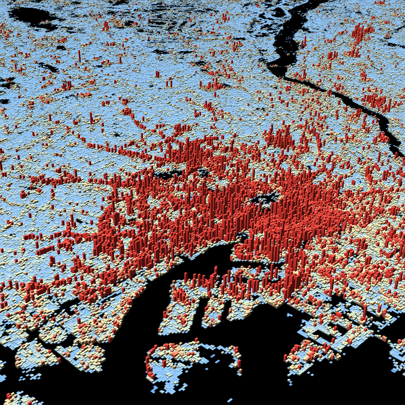
The World Settlement Footprint (WSF) 3D provides detailed quantification of the average height, total volume, total area and the fraction of buildings at 90 m resolution at a global scale. It is generated using a modified version of the World Settlement Footprint human settlements mask derived from Sentinel-1 and Sentinel-2 satellite imagery in combination with digital elevation data and radar imagery collected by the TanDEM-X mission. The framework includes three basic workflows: i) the estimation of the mean building height based on an analysis of height differences along potential building edges, ii) the determination of building fraction and total building area within each 90 m cell, and iii) the combination of the height information and building area in order to determine the average height and total built-up volume at 90 m gridding. In addition, global height information on skyscrapers and high-rise buildings provided by the Emporis database is integrated into the processing framework, to improve the WSF 3D Building Height and subsequently the Building Volume Layer. A comprehensive validation campaign has been performed to assess the accuracy of the dataset quantitatively by using VHR 3D building models from 19 globally distributed regions (~86,000 km2) as reference data. The WSF 3D standard layers are provided in the format of Lempel-Ziv-Welch (LZW)-compressed GeoTiff files, with each file - or image tile - covering an area of 1 x 1 ° geographical lat/lon at a geometric resolution of 2.8 arcsec (~ 90 m at the equator). Following the system established by the TDX-DEM mission, the latitude resolution is decreased in multiple steps when moving towards the poles to compensate for the reduced circumference of the Earth.
-

Buildings provide indispensable services for human wellbeing, but their construction and use are responsible for a substantial fraction of societies’ resource requirements and greenhouse gas emissions. Mapping and quantifying the material stocks in buildings is a key research frontier in Industrial Ecology. Reliable and spatially highly resolved maps of material stocks in buildings world-wide are so far not available. Existing approaches based on nighttime light data allow large-scale coverage, but their spatial resolution is usually ~0.5-1 km. Other methods using light detection and ranging (LiDAR) and cadaster data achieve higher resolution and accuracy, but do not allow wall-to-wall mapping of large regions. Based on high-resolution Earth Observation data combined with material intensity factors (kg per m3 of building volume), we here quantify and map material stocks in buildings at the unprecedented resolution of 90 m globally. We distinguish 18 types of materials in five types of buildings. We find that global material stocks in buildings amount to 547 (391-672) Gt, approximately half of total global societal material stocks. We find highly unequal distributions of material stocks in buildings per capita and per unit area of each country. Our results agree well with previous detailed estimates of material stocks in buildings in dedicated regions or individual cities. Improved and harmonized material intensity factors emerge as a key research area for improving the accuracy of material stock maps. Our results are available as data products with high spatial and thematic resolution to facilitate future studies; e.g., of secondary resource potentials.
-
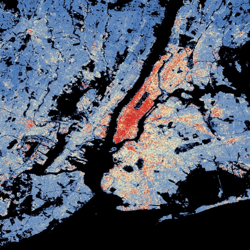
This dataset is a derivative of the WSF3D raster dataset tailored for the web. As a tiled vector dataset, it enables dynamic client-side visualization of the WSF3D metrics
-

The World Settlement Footprint (WSF) 3D provides detailed quantification of the average height, total volume, total area and the fraction of buildings at 90 m resolution at a global scale. It is generated using a modified version of the World Settlement Footprint human settlements mask derived from Sentinel-1 and Sentinel-2 satellite imagery in combination with digital elevation data and radar imagery collected by the TanDEM-X mission. The framework includes three basic workflows: i) the estimation of the mean building height based on an analysis of height differences along potential building edges, ii) the determination of building fraction and total building area within each 90 m cell, and iii) the combination of the height information and building area in order to determine the average height and total built-up volume at 90 m gridding. In addition, global height information on skyscrapers and high-rise buildings provided by the Emporis database is integrated into the processing framework, to improve the WSF 3D Building Height and subsequently the Building Volume Layer. A comprehensive validation campaign has been performed to assess the accuracy of the dataset quantitatively by using VHR 3D building models from 19 globally distributed regions (~86,000 km2) as reference data. The WSF 3D standard layers are provided in the format of Lempel-Ziv-Welch (LZW)-compressed GeoTiff files, with each file - or image tile - covering an area of 1 x 1 ° geographical lat/lon at a geometric resolution of 2.8 arcsec (~ 90 m at the equator). Following the system established by the TDX-DEM mission, the latitude resolution is decreased in multiple steps when moving towards the poles to compensate for the reduced circumference of the Earth.
-
Das Bauforum ist ein Hamburger Veranstaltungsformat mit Tradition. Mit dem siebten Bauforum vom 19. bis 24. August 2019 in den Deichtorhallen wird ein kreatives Versuchslabor ohne Grenzen geschaffen, in dem Ideen von Übermorgen für die Hamburger Magistralen entstehen.
-

Das 3D-Geoportal bietet dreidimensionale Daten (3D-Gebäudemodelle und 3D-Mesh), ein aktuelles Geländemodell, verschiedene Hintergrundkarten sowie Fachdaten. Durch eine Vielzahl von Einstellmöglichkeiten und Funktionen lässt sich Bottrop aus unterschiedlichen Blickwinkeln betrachten. Im 3D-Geoportal sind neben Werkzeugen für das Suchen, das Messen und der Abfrage von Fachinformationen auch weitere Funktionen enthalten, u.a. zur Erstellung von virtuellen Rundflügen, Sichtbarkeitsanalysen oder zur Darstellung von Schatten. Diese erweiterten Funktionen können Sie sich bei Bedarf zur Basisansicht hinzuladen.
-
3D-Gebäude abgeleitet aus der Befliegung 2008