 My GeoNetwork catalogue
Farming
Provided by
Type of resources
Available actions
Topics
Keywords
Contact for the resource
Update frequencies
Service types
-
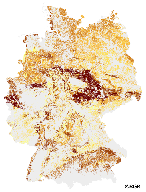
The Muencheberg Soil Quality Rating (SQR) was developed by the Leibniz Centre for Agricultural Landscape Research (ZALF). SQR describes the suitability of sites under agricultural land use and helps to estimate the yield potential of sites at a global scale. This method was especially adapted for application with soil maps by the Federal Institute of Geosciences and Resources BGR and is published in the documentation of Ad-hoc-AG Boden (representing the soil experts of the geological services of the German federal states). The map shows the SQR for cropland in Germany based on the landuse stratified soilmap of Germany at scale 1:1,000,000. Climate (DWD), Relief (BKG) and landuse data (CLC2006) are used as input data in addition to the soil map. SQR consists of a series of pedotransfer rules. First, eight basic soil properties are weighted and combined to describe the soil (substrate, rooting depth, etc.). Next, hazard indicators are derived (drought risk, soil depth above solid rock). These indicators are critical for farming and limit the overall soil quality. Only those hazard indicators were selected for SQR which have the greatest effect on potential grain yield. The final SQR-score ranges from about 0 to 102 points.
-
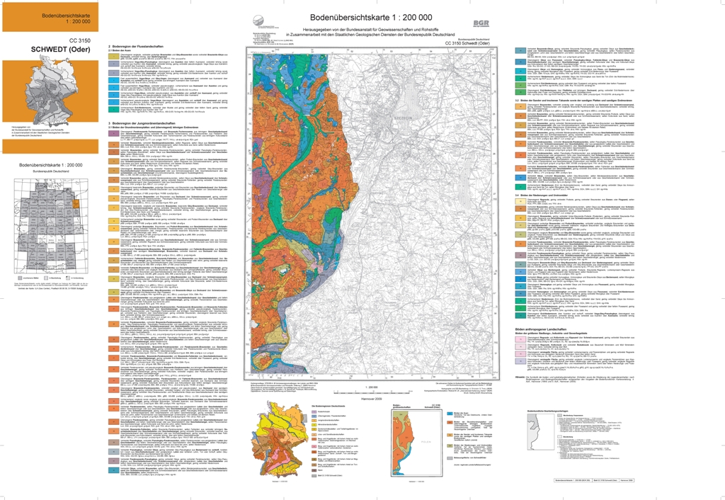
The soil map 1:200,000 (BUEK200) is prepared by the Federal Institute for Geosciences and Natural Resources (BGR) in cooperation with the National Geological Surveys (SGD) of the federal states in the sheet line system of the Topographic Map 1:200,000 (TUEK200) and is published in 55 individual map sheets. The digital data management provides a detailed, nationwide uniform and comprehensive information base for statements on land use and soil protection across the states. Information about the current state of processing can be found on the BGR website about soil. The soil inventories and their spatial distribution on the territory of this map sheet is described in terms of 76 legend units structured by soil regions and landscapes. Each legend unit contains soil systematic information as well as information about the soil parent material of each dominant and associated soil.
-
The soil map 1:200,000 (BUEK200) is prepared by the Federal Institute for Geosciences and Natural Resources (BGR) in cooperation with the National Geological Surveys (SGD) of the federal states in the sheet line system of the Topographic Map 1:200,000 (TUEK200) and is published in 55 individual map sheets. The digital data management provides a detailed, nationwide uniform and comprehensive information base for statements on land use and soil protection across the states. Information about the current state of processing can be found on the BGR website about soil. The soil inventories and their spatial distribution on the territory of this map sheet is described in terms of 97 legend units structured by soil regions and landscapes. Each legend unit contains soil systematic information as well as information about the soil parent material of each dominant and associated soil.
-
The soil map 1:200,000 (BUEK200) is prepared by the Federal Institute for Geosciences and Natural Resources (BGR) in cooperation with the National Geological Surveys (SGD) of the federal states in the sheet line system of the Topographic Map 1:200,000 (TUEK200) and is published in 55 individual map sheets. The digital data management provides a detailed, nationwide uniform and comprehensive information base for statements on land use and soil protection across the states. Information about the current state of processing can be found on the BGR website about soil. The soil inventories and their spatial distribution on the territory of this map sheet is described in terms of 41 legend units structured by soil regions and landscapes. Each legend unit contains soil systematic information as well as information about the soil parent material of each dominant and associated soil.
-
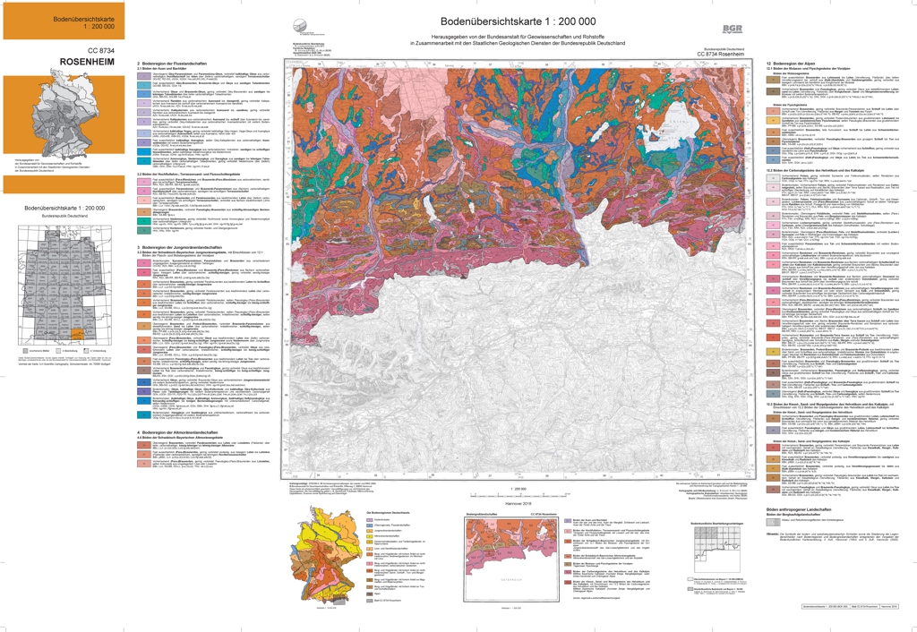
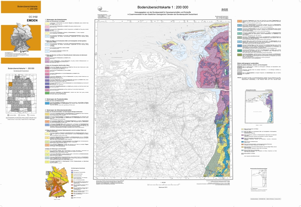
The soil map 1:200,000 (BUEK200) is prepared by the Federal Institute for Geosciences and Natural Resources (BGR) in cooperation with the National Geological Surveys (SGD) of the federal states in the sheet line system of the Topographic Map 1:200,000 (TUEK200) and is published in 55 individual map sheets. The digital data management provides a detailed, nationwide uniform and comprehensive information base for statements on land use and soil protection across the states. Information about the current state of processing can be found on the BGR website about soil. The soil inventories and their spatial distribution on the territory of this map sheet is described in terms of 70 legend units structured by soil regions and landscapes. Each legend unit contains soil systematic information as well as information about the soil parent material of each dominant and associated soil.
-
-
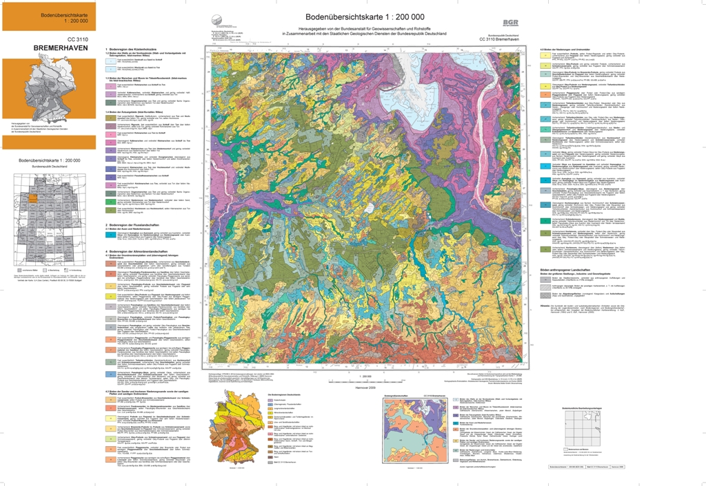
The soil map 1:200,000 (BUEK200) is prepared by the Federal Institute for Geosciences and Natural Resources (BGR) in cooperation with the National Geological Surveys (SGD) of the federal states in the sheet line system of the Topographic Map 1:200,000 (TUEK200) and is published in 55 individual map sheets. The digital data management provides a detailed, nationwide uniform and comprehensive information base for statements on land use and soil protection across the states. Information about the current state of processing can be found on the BGR website about soil. The soil inventories and their spatial distribution on the territory of this map sheet is described in terms of 55 legend units structured by soil regions and landscapes. Each legend unit contains soil systematic information as well as information about the soil parent material of each dominant and associated soil.
-
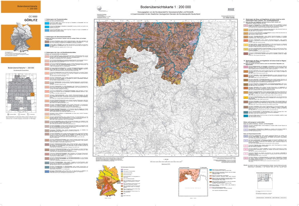
The soil map 1:200,000 (BUEK200) is prepared by the Federal Institute for Geosciences and Natural Resources (BGR) in cooperation with the National Geological Surveys (SGD) of the federal states in the sheet line system of the Topographic Map 1:200,000 (TUEK200) and is published in 55 individual map sheets. The digital data management provides a detailed, nationwide uniform and comprehensive information base for statements on land use and soil protection across the states. Information about the current state of processing can be found on the BGR website about soil. The soil inventories and their spatial distribution on the territory of this map sheet is described in terms of 61 legend units structured by soil regions and landscapes. Each legend unit contains soil systematic information as well as information about the soil parent material of each dominant and associated soil. Last dataset update on October 21, 2014.
-
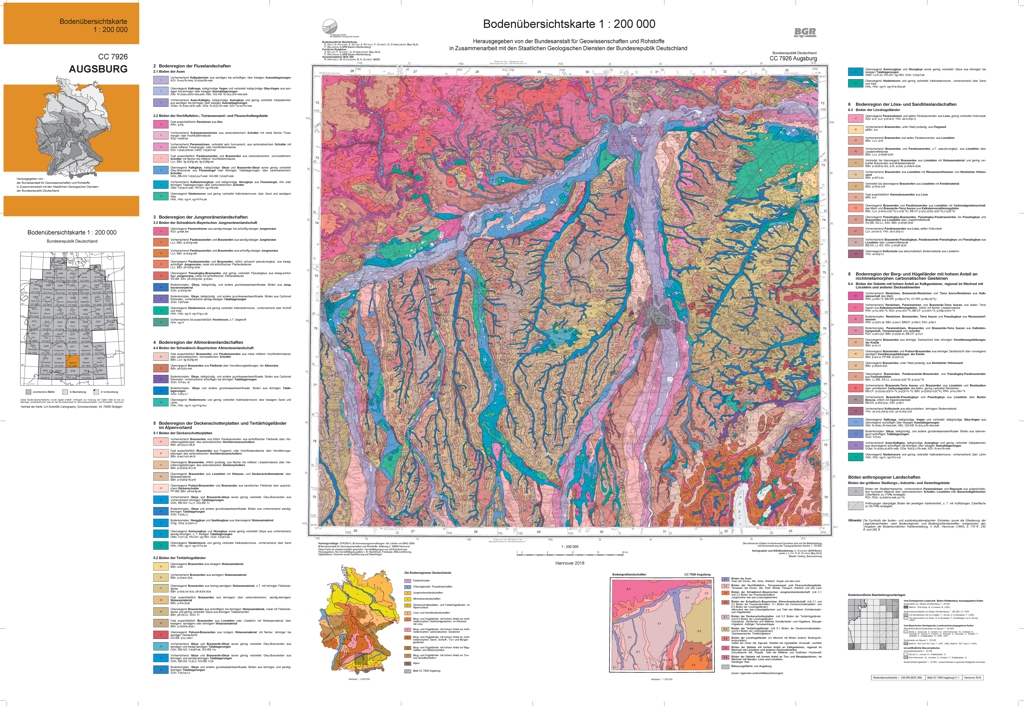
The soil map 1:200,000 (BUEK200) is prepared by the Federal Institute for Geosciences and Natural Resources (BGR) in cooperation with the National Geological Surveys (SGD) of the federal states in the sheet line system of the Topographic Map 1:200,000 (TUEK200) and is published in 55 individual map sheets. The digital data management provides a detailed, nationwide uniform and comprehensive information base for statements on land use and soil protection across the states. Information about the current state of processing can be found on the BGR website about soil. The soil inventories and their spatial distribution on the territory of this map sheet is described in terms of 75 legend units structured by soil regions and landscapes. Each legend unit contains soil systematic information as well as information about the soil parent material of each dominant and associated soil. Last dataset update on November 10, 2017.
-
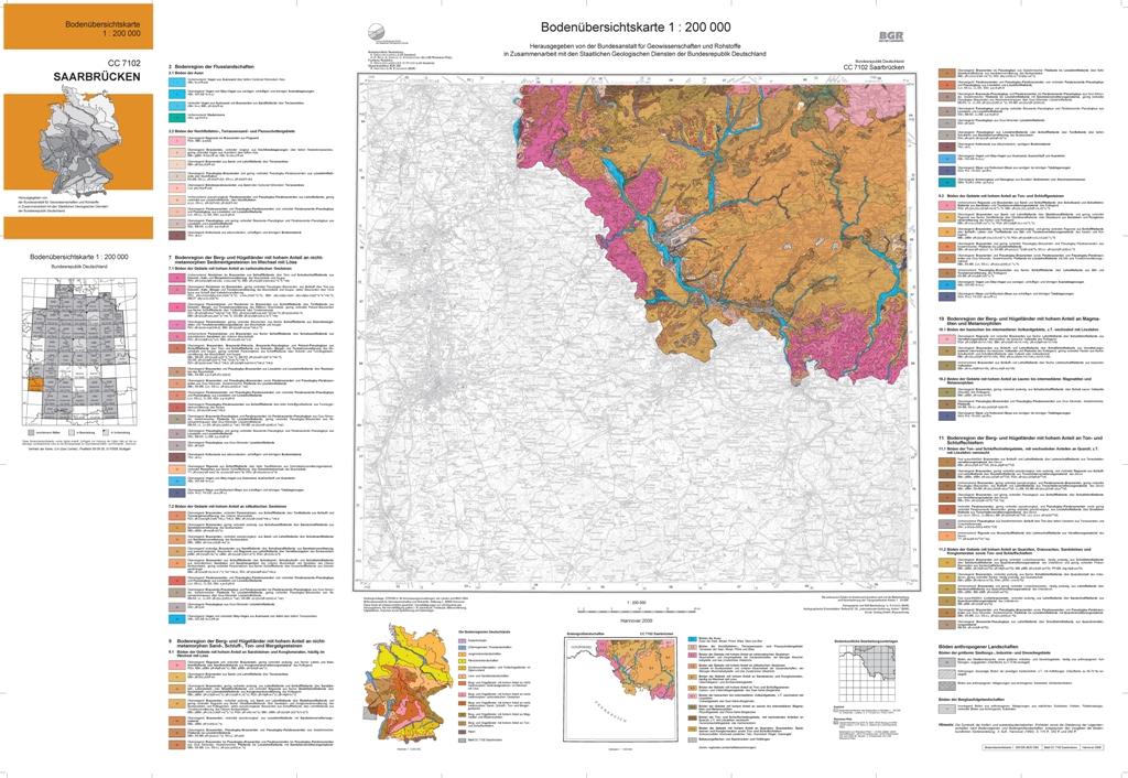
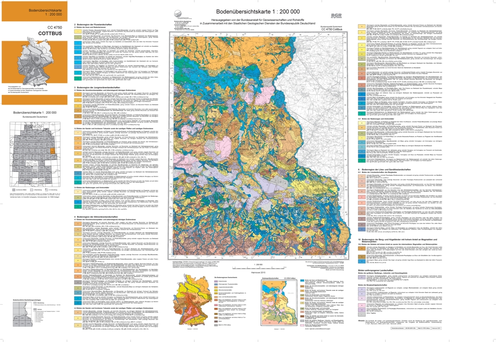
The soil map 1:200,000 (BUEK200) is prepared by the Federal Institute for Geosciences and Natural Resources (BGR) in cooperation with the National Geological Surveys (SGD) of the federal states in the sheet line system of the Topographic Map 1:200,000 (TUEK200) and is published in 55 individual map sheets. The digital data management provides a detailed, nationwide uniform and comprehensive information base for statements on land use and soil protection across the states. Information about the current state of processing can be found on the BGR website about soil. The soil inventories and their spatial distribution on the territory of this map sheet is described in terms of 86 legend units structured by soil regions and landscapes. Each legend unit contains soil systematic information as well as information about the soil parent material of each dominant and associated soil.