 My GeoNetwork catalogue
Ostsee
Provided by
Type of resources
Available actions
Topics
Keywords
Contact for the resource
Update frequencies
Service types
-
Die Daten zeigen Ergebnisse des Bundesamtes für Seeschifffahrt und Hydrographie (BSH) zur Überwachung der Radioaktivität in der Nord- und Ostsee. Die Farbe des angezeigten Punktes gibt die Höhe der Gesamt-Gamma künstl-Aktivität in der entsprechenden Maßeinheit wieder. Zusätzliche Informationen zur Messung wie Messbeginn, Messstation, Medium, Maßeinheit erhalten Sie über den Mausklick auf den Punkt. Das Messnetz wird vom BSH im Rahmen des Integrierten Mess- und Informationssystems (IMIS) betrieben. (siehe [<a href='http://www.bfs.de/DE/themen/ion/notfallschutz/messnetz/imis/imis_node.html' target='new'>http://www.bfs.de/DE/themen/ion/notfallschutz/messnetz/imis/imis_node.html</a>] Weitere Informationen zur Radioaktivität in Meerwasser finden Sie im Jahresbericht 2011 zur Umweltradioaktivität und Strahlenbelastung [<a href='http://nbn-resolving.de/urn:nbn:de:0221-2013090511044' target='new'>http://nbn-resolving.de/urn:nbn:de:0221-2013090511044</a>].
-
The major pre-alpine tectonic lineaments as the Glückstadt Graben and the Avalonia-Baltica suture zone run across the southern Baltic. The BalTec expedition aimed at the gapless imaging of these fault systems from the seafloor down to the Paleozoic basement. Scientifically the expedition was motivated by two hypotheses. We postulated that advances and retreats of icesheets during the glacials initiated and reactivated faulting of the Post-Permian succession, thereby generating several kilometers long near-vertical faults and anticlines. We further postulated that – in contrast to the generally accepted text book models – deformation of the initially up to 1800 m thick Zechstein salt started already during salt deposition as the consequence of salt load induced basin subsidence and resulting salt creep. The profile network was further designed to allow for linking the stratigraphy between previously generated local underground models in the frame of the TUNB project. Altogether we collected during cruise MSM52 onboard of R/V Maria S. Merian 62 reflection seismic profiles of an entire length of 3500 km. This data set contains all seismic lines located in the German EEZ (lines BGR16-212 to BGR16-264) as time-migrated version.
-
The dataset includes the locations of OBS stations (Ocean Bottom Seismometers) operated in the German Bight during cruise MSM100 with R.V. Maria S. Merian. The time interval from 13.05.2021 to 15.05.2021 has been analysed in a phase without airgun operation for passive recording with 4.5 Hz geophones. Furthermore, the dataset contains locations of 3 broadband OBS systems which were operated during an experiment at the Darss ramp in the German Baltic Sea. The records were analysed in the time interval 23.01.2018 to 01.04.2018.
-
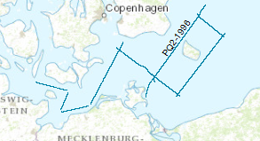
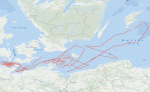
Processed seismic data from Baltic Sea with research ship M/V Polar Queen.The data format is Society of Exploration Geophysicists SEG Y. During the period from 14th to 28th of April 1996 BGR and GFZ chartered the Norwegian vessel M/V POLAR QUEEN for testing the new and updated marine seismic equipment of the BGR and for acquiring seismic lines. The operating area was the North Sea and Baltic Sea. The geophysical lines in the Baltic Sea were chosen as extended onshore DEKORP lines to evaluate the deep structure of the south western part of the Baltic Sea. For the seismic profiles a tuned source array consisting of 20 air guns in two linear strings with a total volume of 52 l was used. The recording length was 26 s, the sample rate 4 ms and the shot interval 30 s. This time triggering for the shot release was chosen, because all shots were also recorded onshore by seismic stations for wide angle/refraction acquisition (GFZ). During this leg 810 km reflection lines and additional 230 km pure shooting could be surveyed. The preliminary interpretation of the seismic single traces was restricted on the ship to the upper time range. The main structures in the southern Baltic Sea could be evaluated. A full interpretation especially of the deeper part is only possible after a processing due to the nature of the single traces and the S/N ratio.
-
.png)
The WMS MSSP-EEZ (INSPIRE) represents marine seismic survey profiles for the German EEZ. During the period from 1996 to 2007 five cruises operated by BGR acquired seismic lines from the German EEZ. The aim of these cruises was a detailed survey of the geological structure of the seabed from the North Sea and Baltic Sea. According to the Data Specification on Geology (D2.8.II.4_v3.0, subtopic Geophysics) the content of the information with respect to the seismic profiles is INSPIRE-compliant. The WMS MSSP-EEZ (INSPIRE) contains for each cruise one layer, e.g. GE.seismicLine.pq2. The expeditions are displayed correspondingly to the INSPIRE portrayal rules. Via the getFeatureInfo request the user obtains the content of the INSPIRE attributes platformType und profileType. Additionally, the WMS contains a campaign layer (GE.2DSeismicSurvey) with the INSPIRE attributes campaignType and surveyType.
-
During the period from 1996 to 2007 five cruises operated by BGR acquired seismic lines from the German EEZ. The aim of these expeditions was a detailed survey of the geological structure of the seabed from the North Sea and Baltic Sea. The five GML files (for each cruise one) together with a Readme.txt file are provided in ZIP format (MSSP-EEZ-INSPIRE.zip). The Readme.text file (German/English) contains detailed information on the GML files content. Data transformation was proceeded by using the INSPIRE Solution Pack for FME according to the INSPIRE requirements.
-
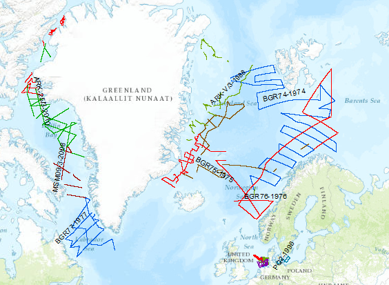
During the period from 1974 to 2018 various cruises from BGR acquired seismic lines worldwide. The aim of these marine expeditions was a detailed survey of the geological structure.
-
During the period from 1974 to 2023 various cruises from BGR acquired seismic lines worldwide. The aim of these marine expeditions were a detailed survey of the geological structure of seabed.
-
Bekannte Vorkommen des LRT 1110 Sandbänke mit nur schwacher ständiger Überspülung durch Meerwasser, Anhang I FFH-Richtlinie und Vorkommen 1170 Riffe gemäß Anhang I FFH-Richtlinie