 My GeoNetwork catalogue
Nordsee
Provided by
Type of resources
Available actions
Topics
Keywords
Contact for the resource
Update frequencies
Service types
-
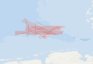
Regarding the use of renewable energy and the reduction of greenhouse-gas emissions, the geological storage of fluids is of particular interest. Therefore, reservoir and barrier formations in the German North Sea come into focus. Due to the widespread distribution of storage and barrier rocks at suitable depths and in combination with a relatively low tectonic overprint, the West Schleswig Block region in the German North Sea shows a high prospectivity for CO2 storage. By means of this high-resolution 2D reflection seismic survey, we want to investigate the potential impairment of geological barriers at the top of geological storage formations (i.e. claystones/mudstones and salt of the Upper Buntsandstein, mudstone dominated formations of the Lower Cretaceous and of the Tertiary). The seismic acquisition setup with a 2400 m active streamer cable with 384 channels will allow a precise image of near-surface structures, such as Quaternary channels, seismic pipe structures, chimneys, polygonal fault systems and crestal faults. In the time period between Nov. 13th and Nov. 24th we acquired 32 lines 2D seismic reflection data (about 1500 km in total) in combination with gravity data, multibeam data and sediment echosounder data. The seismic data resolve the sediments from the seafloor down to the base of the Zechstein. With the acquired data, the sediments of the Mesozoic and Cenozoic up to the seafloor (2-3 seconds of twoway-traveltime) will be imaged in high-resolution for the first time. The imaged fault systems will be investigated regarding their ability to build seal bypass systems. In addition, we acquired seismic data across the Figge Maar blowout crater and we intend to compare these data with the seismic data from the West Schleswig Block.
-
Die Daten zeigen Ergebnisse des Bundesamtes für Seeschifffahrt und Hydrographie (BSH) zur Überwachung der Radioaktivität in der Nord- und Ostsee. Die Farbe des angezeigten Punktes gibt die Höhe der Gesamt-Gamma künstl-Aktivität in der entsprechenden Maßeinheit wieder. Zusätzliche Informationen zur Messung wie Messbeginn, Messstation, Medium, Maßeinheit erhalten Sie über den Mausklick auf den Punkt. Das Messnetz wird vom BSH im Rahmen des Integrierten Mess- und Informationssystems (IMIS) betrieben. (siehe [<a href='http://www.bfs.de/DE/themen/ion/notfallschutz/messnetz/imis/imis_node.html' target='new'>http://www.bfs.de/DE/themen/ion/notfallschutz/messnetz/imis/imis_node.html</a>] Weitere Informationen zur Radioaktivität in Meerwasser finden Sie im Jahresbericht 2011 zur Umweltradioaktivität und Strahlenbelastung [<a href='http://nbn-resolving.de/urn:nbn:de:0221-2013090511044' target='new'>http://nbn-resolving.de/urn:nbn:de:0221-2013090511044</a>].
-
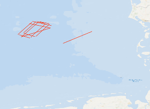
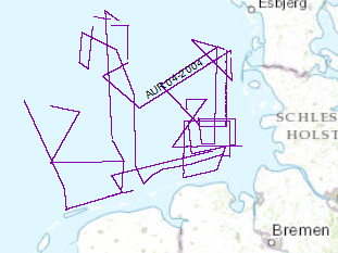
The cruise AL278 started on May, 10th 2006 in Kiel and ended in Kiel on May, 19th 2006. The previous BGR-cruises with RV AURELIA in 2003 and 2004 were designed to collect a grid of seismic MCS-data which should enable us to get a high-resolution overview over the upper 1 s TWT of the sediments of the German North Sea sector. During October/November 2005 a subsequent cruises with RV HEINCKE and FK SENCKENBERG was designed to tackle several special aims: - The detailed mapping of glacio-tectonic features North of Heligoland. - The shallow seismic mapping of the Holocene/Pleistocene-Boundary and topography of the Pleistocene sub-glacial valley system offshore of the East Friesian Islands. - High-resolution surveying of two areas designated for offshore wind farms in the southwestern German sector. - Detailed mapping of a wide and deep sub-glacial valley. One additional aim was to acquire a dense grid of seismic line in the area North of Weisse Bank where on several from previous cruises indications for shallow gas accumulations (e.g. “bright spots”) were found. Unfortunately, due to very bad weather conditions this aim could not be reached. Therefore this short cruise with RV ALKOR was used to acquire twelve MCS lines over this area. During the cruise a total ca. 1400 km of high quality MCS lines were surveyed and simultaneously measured by a sediment echosounder system that enabled additional profiles during transits with speeds 5 kn. Together with the previously acquired data these new data should help to extend our knowledge of the Late Tertiary and Quaternary evolution of the German North Sea Sector. The BGR high-resolution multichannel seismic reflection system consisting of a GI-Gun (0.8 l) and a 300 m streamer with 24 channels and a sediment echosounder type SES 2000 standard by Innomar, Rostock. While the BGR-seismic system was used to observe the shallow subsurface down to 2 s TWT penetration depth, the sediment echosounder with a penetration depth of several meters was primarily intended to identify sampling positions for the deployment of the BGR vibration corer during the succeeding Leg 2. Additionally, the echosounder system enables the relationship to the highest-resolution multichannel seismic measurements of the group of the University of Bremen on FK SENCKENBERG. All seismic records were processed onboard for the quality control and for a first interpretation.
-
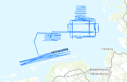
The previous BGR-cruises with RV AURELIA in 2003 and 2004 were designed to collect a grid of seismic MCS-data which should enable us to get a high-resolution overview over the upper 1 s TWT of the sediments of the German North Sea sector. The data format is Society of Exploration Geophysicists SEG Y. Together with the previously acquired data these new data should help to extend our knowledge of the Late Tertiary and Quaternary evolution of the German North Sea Sector. For the current measurements under the scope of the DFG-funded project RE2424/1-1 ‚Nordsee’ the research vessel RV HEINCKE was made available by the ‘Senatskommission für Ozeanographie’ of the DFG. During the cruise a total ca. 1400 km of high quality MCS lines were surveyed and simultaneously measured by a sediment echosounder system that enabled additional profiles during transits with speeds > 5 kn. The BGR high-resolution multichannel seismic reflection system consisting of a GI-Gun (0.8 l) and a 300 m streamer with 24 channels and a sediment echosounder type SES 2000 standard by Innomar, Rostock. While the BGR-seismic system was used to observe the shallow subsurface down to 2 s TWT penetration depth, the sediment echosounder with a penetration depth of several meters was primarily intended to identify sampling positions for the deployment of the BGR vibration corer during the succeeding Leg 2. Additionally, the echosounder system enables the relationship to the highest-resolution multichannel seismic measurements of the group of the University of Bremen on FK SENCKENBERG. All seismic records were processed onboard for the quality control and for a first interpretation.
-
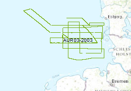
The late Tertiary and Quaternary development of the German EEZ was systematically inverstigated by seismic profiling. The data format is Society of Exploration Geophysicists SEG Y. For that survey the privately owned motor vessel AURELIA was chartered for a period of 24 days from the 16th of September to 10th of October 2003. A more or less equidistant E-W and N-S grid of profiles with a length of 2500 km was surveyed by high-resolution multichannel seismic system. A 0.82 litre GI-Gun was employed every 12.5 m and the reflected signals were recorded by a 300 m long streamer. Simultaneously a deep-towed HUNTEC-Boomer or a GEO-Sparker was run (150km/620km). All seismic records were processed onboard for the quality control and for a first interpretation.
-
Continuing the systematic work which was started during a previous BGR expedition with RV AURELIA in Sept./Oct. 2003 the late Tertiary and Quaternary development of the German EEZ was further investigated by seismic profiling. The data format is Society of Exploration Geophysicists SEG Y. Again the research vessel AURELIA was chartered for a period of 21 days from 31st of May to 19th of June 2004. During the cruise the grid of seismic profiles which was aquired in 2003 was completed and data gaps were closed. A total of 2618km of high quality MCS lines were surveyed.
-
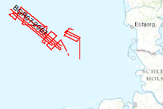
The previous BGR-cruises with RV AURELIA in 2003 and 2004 and RV HEINCKE in 2005 and RV ALKOR in 2006 were designed to collect a grid of seismic MCS-data which should enable us to get a high-resolution overview over the upper 1-2 s TWT of the sediments of the German North Sea sector. The data format is Society of Exploration Geophysicists SEG Y. The aim of this cruise was a detailed survey in the north westernmost area of the German EEZ (exclusive economic zone), the so-called ‘Entenschnabel’ and additionally a mapping of special glacial structures off Sylt Island. The cruise was subdivided into two Legs. One outreaching additional aim was to extend the results from the previous cruises for the Late Tertiary and Quaternary sedimentary evolution into the ‘Entenschnabel’-area which was virtually unexplored by systematic shallow high-resolution seismics. During Leg 1 the BGR high-resolution multichannel seismic reflection system consisting of a GI-Gun (0.8 l) and a 500 m streamer with 36 channels and a shallow swath bathymetric system, type SIMRAD EM1200 by Kongsberg, Bergen, Norway were used. While the BGR-seismic system was used to observe the shallow subsurface down to 2 s TWT penetration depth, the swath bathymetric system was used to identify possible pockmark locations as well as sampling positions for the deployment of the BGR vibration corer during the succeeding Leg 2. All seismic records were processed onboard for the quality control and for a first interpretation loaded into GEOQUEST.
-
.png)
The WMS MSSP-EEZ (INSPIRE) represents marine seismic survey profiles for the German EEZ. During the period from 1996 to 2007 five cruises operated by BGR acquired seismic lines from the German EEZ. The aim of these cruises was a detailed survey of the geological structure of the seabed from the North Sea and Baltic Sea. According to the Data Specification on Geology (D2.8.II.4_v3.0, subtopic Geophysics) the content of the information with respect to the seismic profiles is INSPIRE-compliant. The WMS MSSP-EEZ (INSPIRE) contains for each cruise one layer, e.g. GE.seismicLine.pq2. The expeditions are displayed correspondingly to the INSPIRE portrayal rules. Via the getFeatureInfo request the user obtains the content of the INSPIRE attributes platformType und profileType. Additionally, the WMS contains a campaign layer (GE.2DSeismicSurvey) with the INSPIRE attributes campaignType and surveyType.
-
During the period from 1996 to 2007 five cruises operated by BGR acquired seismic lines from the German EEZ. The aim of these expeditions was a detailed survey of the geological structure of the seabed from the North Sea and Baltic Sea. The five GML files (for each cruise one) together with a Readme.txt file are provided in ZIP format (MSSP-EEZ-INSPIRE.zip). The Readme.text file (German/English) contains detailed information on the GML files content. Data transformation was proceeded by using the INSPIRE Solution Pack for FME according to the INSPIRE requirements.
-
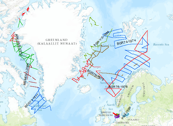
During the period from 1974 to 2018 various cruises from BGR acquired seismic lines worldwide. The aim of these marine expeditions was a detailed survey of the geological structure.