 www.geodatenkatalog.de (S1F)
Keyword
Land cover
135 record(s)
Provided by
Type of resources
Available actions
Topics
Keywords
Contact for the resource
Update frequencies
Service types
-
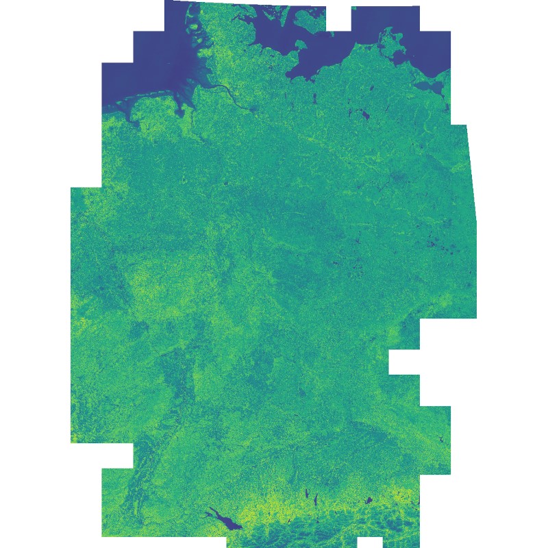
This dataset includes the normalized difference vegetation index (NDVI) derived from Sentinel-2 imagery. Using the Google Earth Engine, all granules with a cloud cover below 60% were used as input. Cloudy pixels (referring to quality layer QA60) were masked as well. Eventually, a median mosaic was composed over the whole observation period. It was also used as input for a land cover classification (see: Land Cover DE - Sentinel-2 - Germany, 2015).
-

The Sentinel-2 fractional vegetation cover (fCover) product for the Netherlands was produced as part of the NextGEOSS project at the German Aerospace Center (DLR). The goal is to derive abundance maps from atmospherically corrected Sentinel-2 multispectral images for: photosynthetically active vegetation (PV); and for combined non-photosynthetically active vegetation (NPV) and bare soil (BS). The fCover product for the Netherlands has been generated by processing 10 cloud-free Sentinel-2 tiles which covered the country on 8 September 2016. The map has a spatial resolution of 60m x 60m. The Sentinel-2 scene classification layer was used to ensure that the spectral unmixing was only performed on areas of vegetation or soil. The abundance maps were made by performing MESMA unmixing on each pixel from an endmember library of PV and combined NPV + BS spectra. The purest pixels in a scene, called endmembers, were extracted using the Spatial-Spectral Endmember Extraction (SSEE) approach. The PV and NPV+BS endmembers were classified with a random forest approach and selected to form the spectral library. The spectral library was used in the µMESMA unmixing to get the PV and NPV+BS abundances.
-
The objective of the pan-European project CORINE Land Cover (CLC) is the provision of a unique and comparable data set of land cover for Europe and the delivery of regular updates to register also the land cover and land use changes over time. It is part of the European Union programme CORINE (Coordination of Information on the Environment). The mapping of the land cover and land use was performed on the basis of satellite remote sensing images. The first CLC data base CLC1990, which was finalized in the 1990s, consistently provided land use information comprising 44 classes, out of which 37 classes are relevant in Germany. The first two updates for Europe were based on the reference years 2000 and 2006. For Germany, DLR-DFD was responsible for the creation of CLC2000 and CLC2006 on behalf of the Federal Environment Agency. In addition to the updated land cover, change datasets were also parts of the project. For deriving a meaningful CLC2000 change product, it became necessary to re-interprete parts of the satellite data of 1990 and to create a revised product, called CLC1990 (rev). Further details: https://www.dlr.de/en/eoc/research-transfer/projects-missions/corine-land-cover
-
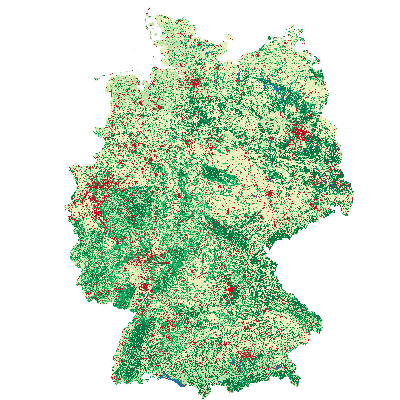
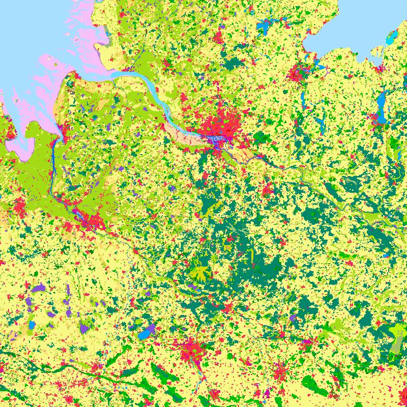
This land cover classification of Germany was created using Sentinel-2 imagery from the years 2015 to 2017 and LUCAS 2015 in-situ reference data (https://ec.europa.eu/eurostat/web/lucas). It contains seven land cover types: (1) artificial land, (2) open soil, (3) high seasonal vegetation, (4) high perennial vegetation, (5) low seasonal vegetation, (6) low perennial vegetation and (7) water with a spatial resolution of 10m x 10m. For further information, please see the following publication: https://doi.org/10.1016/j.jag.2020.102065
-

The objective of the pan-European project CORINE Land Cover (CLC) is the provision of a unique and comparable data set of land cover for Europe and the delivery of regular updates to register also the land cover and land use changes over time. It is part of the European Union programme CORINE (Coordination of Information on the Environment). The mapping of the land cover and land use was performed on the basis of satellite remote sensing images. The first CLC data base CLC1990, which was finalized in the 1990s, consistently provided land use information comprising 44 classes, out of which 37 classes are relevant in Germany. The first two updates for Europe were based on the reference years 2000 and 2006. For Germany, DLR-DFD was responsible for the creation of CLC2000 and CLC2006 on behalf of the Federal Environment Agency. In addition to the updated land cover, change datasets were also parts of the project. For deriving a meaningful CLC2000 change product, it became necessary to re-interprete parts of the satellite data of 1990 and to create a revised product, called CLC1990 (rev). Further details: https://www.dlr.de/en/eoc/research-transfer/projects-missions/corine-land-cover
-
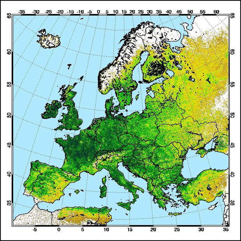
The "AVHRR compatible Normalized Difference Vegetation Index derived from MERIS data (MERIS_AVHRR_NDVI)" was developed in a co-operative effort of DLR (German Remote Sensing Data Centre, DFD) and Brockmann Consult GmbH (BC) in the frame of the MAPP project (MERIS Application and Regional Products Projects). For the generation of regional specific value added MERIS level-3 products, MERIS full-resolution (FR) data are processed on a regular (daily) basis using ESA standard level-1b and level-2 data as input. The regular reception of MERIS-FR data is realized at DFD ground station in Neustrelitz. The Medium Resolution Imaging MERIS on Board ESA's ENVISAT provides spectral high resolution image data in the visible-near infrared spectral region (412-900 nm) at a spatial resolution of 300 m. For more details on ENVISAT and MERIS see http://envisat.esa.int The Advanced Very High Resolution Radiometer (AVHRR) compatible vegetation index (MERIS_AVHRR_NDVI) derived from data of the MEdium Resolution Imaging Spectrometer (MERIS) is regarded as a continuity index with 300 meter resolution for the well-known Normalized Difference Vegetation Index (NDVI) derived from AVHRR (given in 1km spatial resolution). The NDVI is an important factor describing the biological status of canopies. This product is thus used by scientists for deriving plant and canopy parameters. Consultants use time series of the NDVI for advising farmers with best practice. For more details the reader is referred to http://wdc.dlr.de/sensors/meris/ and http://wdc.dlr.de/sensors/meris/documents/Mapp_ATBD_final_i3r0dez2001.pdf This product provides monthly maps.
-
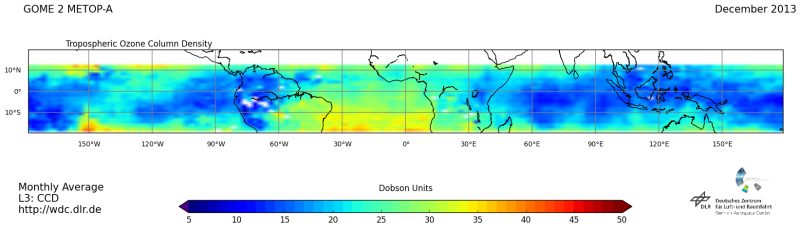
GOME (Global Ozone Monitoring Experiment) stands for a family of satellite instruments named after the first GOME (https://wdc.dlr.de/sensors/gome/) instrument on ERS-2 launched in April 1995. Currently two GOME-2 instruments are operative on Metop-A and B (https://wdc.dlr.de/sensors/gome2/). The tropical tropospheric ozone is retrieved with convective cloud differential method (Valks et al., 2014 http://www.atmos-meas-tech.net/7/2513/2014/amt-7-2513-2014.html). The tropospheric column is retrieved by subtracting the stratospheric ozone column from the total column. The stratospheric ozone column is estimated as the column above high reaching convective clouds.