 My GeoNetwork catalogue
Bodenfunktion
Provided by
Type of resources
Available actions
Topics
Keywords
Contact for the resource
Update frequencies
Service types
-

-

-

-

-
-

-
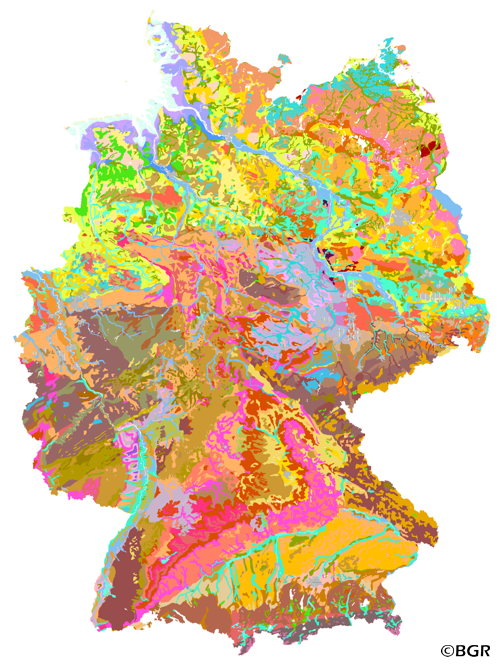
Web Map Service (WMS) of the BUEK1000. The first country wide soil map at a scale of 1:1,000,000 (BUEK1000) has been compiled on the basis of published soil maps of the former German Democratic Republic and the pre 1990 federal states of Germany. To do this, it was necessary to match the soil systems used in East and West Germany and to develop standardized descriptions of soil units. A relatively homogeneous map has resulted, which permits uniform assessment of the soils throughout Germany. The map shows 71 soil mapping units, described in the legend on the basis of the German and FAO soil systems. Each soil unit has been assigned a characteristic soil profile (Leitprofil) as an aid to map interpretation. For the first time the subdivision of the country into 12 soil regions has been represented on the map. This subdivision was coordinated with the state Geological Surveys. These soil regions will represent the highest hierarchic level of nation wide soil maps in future. The colours of soil units correspond to the standards of the 'Bodenkundliche Kartieranleitung' (KA 3; Guidelines for Soil Mapping). The various hues characterize differences in relief or soil humidity. The BUEK1000 was produced digitally. It is an important part of the spatial database integrated in the Soil Information System currently being established at the Federal Institute for Geosciences and Natural Resources (FISBo BGR). It can be used together with the characteristic soil profiles to derive thematic maps related to nation wide soil protection. The scale of the BUEK1000 makes it especially suitable for small scale evaluations at federal or EU level.
-
The first country wide soil map at a scale of 1:1,000,000 (BUEK1000) has been compiled on the basis of published soil maps of the former German Democratic Republic and the pre 1990 federal states of Germany. To do this, it was necessary to match the soil systems used in East and West Germany and to develop standardized descriptions of soil units. A relatively homogeneous map has resulted, which permits uniform assessment of the soils throughout Germany. The map shows 71 soil mapping units, described in the legend on the basis of the German and FAO soil systems. Each soil unit has been assigned a characteristic soil profile (Leitprofil) as an aid to map interpretation. For the first time the subdivision of the country into 12 soil regions has been represented on the map. This subdivision was coordinated with the state Geological Surveys. These soil regions will represent the highest hierarchic level of nation wide soil maps in future. The colours of soil units correspond to the standards of the 'Bodenkundliche Kartieranleitung' (KA 3; Guidelines for Soil Mapping). The various hues characterize differences in relief or soil humidity. The BUEK1000 was produced digitally. It is an important part of the spatial database integrated in the Soil Information System currently being established at the Federal Institute for Geosciences and Natural Resources (FISBo BGR). It can be used together with the characteristic soil profiles to derive thematic maps related to nation wide soil protection. The scale of the BUEK1000 makes it especially suitable for small scale evaluations at federal or EU level.
-
Böden erfüllen wichtige Funktionen im Naturhaushalt. Das Bundesbodenschutzgesetz schützt diese wertvollen Bodenfunktionen. Mit Bodenfunktionskarten wird die Leistungsfähigkeit der Böden im Naturhaushalt bewertet. Die Bewertung erfolgt auf der Grundlage von Bodenkarten (meist Übersichtsbodenkarten i.M. 1:25.000) und weiteren flächig vorliegenden Informationen zu Umwelt und Standort. Die Flächeninformationen werden mit Hilfe von Verknüpfungsregeln zu Bewertungen umgesetzt. Der Boden mit seinen Wasser- und Nährstoffkreisläufen ist einer der wichtigsten Standortfaktoren für die Ansiedlung und Entwicklung von Pflanzengesellschaften. Die Bewertung des Bodens als Lebensraum für die natürliche Vegetation wird anhand des Kriteriums "Standortpotenzial für die natürliche Vegetation" vorgenommen. Dabei werden durch die Kombination der Parameter Basen-, Nährstoff- und Wasserhaushalt Standorttypen des Bodens ausgeschieden und extreme Standortausprägungen als Potenzial für die Ansiedlung seltener Lebensgemeinschaften bewertet. Die Karten können verwendet werden, um Suchräume z.B. im Rahmen von Planungen zur Biotopvernetzung oder bei der Durchführung von Ausgleichsmaßnahmen auszuscheiden. Die Bodenfunktionskarte "Boden als Lebensraum für die natürliche Vegetation" stellt eine bodenschutzfachliche Auswertung der Bodenkarte dar. Da die Basisdaten der Bodenfunktionskarte teilweise auf unterschiedlichen topographischen Grundlagen basieren, treten beim Abgleich mit aktuellen Nutzungskarten insbesondere an Nutzungsgrenzen Verschneidungsungenauigkeiten auf. Teilweise sind die bewerteten Flächen in der Bodenfunktionenkarte sehr inhomogen, so dass neben der dargestellten Bewertungsstufe untergeordnet auch abweichende Bewertungen vorkommen. Flächen mit weniger als 5000 m² wurden Nachbarflächen zugeschlagen.
-

Die Bodenfunktionenkarten wurden nach dem Sächsischen Bodenbewertungsinstrument Stand 10/2021 erstellt. Erstmalig wurden alle für die Bewertung eingesetzten 1200 Leitprofile der digitalen Bodenkarte 1:50.000 einer Laboruntersuchung unterzogen. Die Bodenkarte 1:50.000 basiert auf den 54 Einzelblättern des Freistaates Sachsen. Sukzessive werden die neue Kenntnisstände zum Boden und Bodenschutz in die Bewertungen der Bodenfunktionen eingearbeitet. Diese Informationen werden mit Updates veröffentlicht.