Keyword

Bodennutzung

429719 record(s)


Provided by

Type of resources

Available actions

Topics

Keywords

Contact for the resource

Update frequencies

Service types

From 1 - 10 / 429719
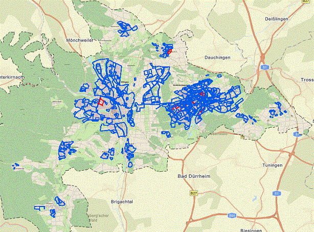
  • Der Download-Dienst bietet eine Zugriffsmöglichkeit auf die Geltungsbereiche der rechtskräftigen Bebauungspläne der Stadt Villingen-Schwenningen. Als Attribute sind neben den Informationen zum Namen, Nummer, Inkrafttretungsdatum, … auch der WMS-Dienst Link etc. hinterlegt. Zusätzliche Informationen findet man in der Bebauungsplan-App der Stadt

  • Dieser Dienst beinhaltet die Waldkarte von Mecklenburg-Vorpommern. Die Daten enthalten den derzeitigen Erfassungsstand von Waldflächen nach LWaldG M-V. Die Daten der Waldkarte werden von der Landesforst Mecklenburg-Vorpommern bereitgestellt.

  • Über diesen WMS-Dienst werden die Öffentlichen Grünanlagen, die (vereinsgebundenen) Kleingartenanlagen, das Baum- und Spielgerätekataster der Stadt Osnabrück dargestellt.

  • The first country wide soil map at a scale of 1:1,000,000 (BUEK1000) has been compiled on the basis of published soil maps of the former German Democratic Republic and the pre 1990 federal states of Germany. To do this, it was necessary to match the soil systems used in East and West Germany and to develop standardized descriptions of soil units. A relatively homogeneous map has resulted, which permits uniform assessment of the soils throughout Germany. The map shows 71 soil mapping units, described in the legend on the basis of the German and FAO soil systems. Each soil unit has been assigned a characteristic soil profile (Leitprofil) as an aid to map interpretation. For the first time the subdivision of the country into 12 soil regions has been represented on the map. This subdivision was coordinated with the state Geological Surveys. These soil regions will represent the highest hierarchic level of nation wide soil maps in future. The colours of soil units correspond to the standards of the 'Bodenkundliche Kartieranleitung' (KA 3; Guidelines for Soil Mapping). The various hues characterize differences in relief or soil humidity. The BUEK1000 was produced digitally. It is an important part of the spatial database integrated in the Soil Information System currently being established at the Federal Institute for Geosciences and Natural Resources (FISBo BGR). It can be used together with the characteristic soil profiles to derive thematic maps related to nation wide soil protection. The scale of the BUEK1000 makes it especially suitable for small scale evaluations at federal or EU level.

  • Web Map Service (WMS) of the BUEK1000. The first country wide soil map at a scale of 1:1,000,000 (BUEK1000) has been compiled on the basis of published soil maps of the former German Democratic Republic and the pre 1990 federal states of Germany. To do this, it was necessary to match the soil systems used in East and West Germany and to develop standardized descriptions of soil units. A relatively homogeneous map has resulted, which permits uniform assessment of the soils throughout Germany. The map shows 71 soil mapping units, described in the legend on the basis of the German and FAO soil systems. Each soil unit has been assigned a characteristic soil profile (Leitprofil) as an aid to map interpretation. For the first time the subdivision of the country into 12 soil regions has been represented on the map. This subdivision was coordinated with the state Geological Surveys. These soil regions will represent the highest hierarchic level of nation wide soil maps in future. The colours of soil units correspond to the standards of the 'Bodenkundliche Kartieranleitung' (KA 3; Guidelines for Soil Mapping). The various hues characterize differences in relief or soil humidity. The BUEK1000 was produced digitally. It is an important part of the spatial database integrated in the Soil Information System currently being established at the Federal Institute for Geosciences and Natural Resources (FISBo BGR). It can be used together with the characteristic soil profiles to derive thematic maps related to nation wide soil protection. The scale of the BUEK1000 makes it especially suitable for small scale evaluations at federal or EU level.

  • Satzungen, Begründungen, zusammenfassende Erklärungen

  • An der Straße nach Westerflach - 1. Änderung

  • Hartweg - Kleines Eschle III

  • Blech und Stahl sowie 1. Änderung Esseratsweiler Ost

Barrierefreiheit | Datenschutz | Impressum